Related Research Articles

Nordland is one of the three northernmost counties in Norway in the Northern Norway region, bordering Troms in the north, Trøndelag in the south, Norrbotten County in Sweden to the east, Västerbotten County to the south-east, and the Atlantic Ocean to the west. The county was formerly known as Nordlandene amt. The county administration is in the town of Bodø. The remote Arctic island of Jan Mayen has been administered from Nordland since 1995. In the southern part of the county is Vega, listed on the UNESCO World Heritage Site list.

Dovre is a municipality in Innlandet county, Norway. It is located in the traditional district of Gudbrandsdal. The administrative centre of the municipality is the village of Dovre. Other villages in Dovre include Dombås and Hjerkinn. The municipality is bordered on the north by Oppdal municipality, on the east by Folldal, on the south by Sel and Vågå, and on the northwest by Lesja. The highest peak in the municipality is Snøhetta at a height of 2,286 metres (7,500 ft).

Valle is a municipality in Agder county, Norway. It is located in the traditional district of Setesdal. The administrative centre of the municipality is the village of Valle. Other villages in Valle include Besteland, Brokke, Homme, Hovet, Rygnestad, Rysstad, and Uppstad.

Hamarøy (Norwegian) or Hábmer (Lule Sami) is a municipality in Nordland county, Norway. It is part of the traditional district of Salten. The administrative centre of the municipality is the village of Oppeid. Other villages include Drag, Hellmobotn, Innhavet, Karlsøy, Korsnes, Presteid, Skutvika, Tømmerneset, Tranøya, and Ulvsvåg.
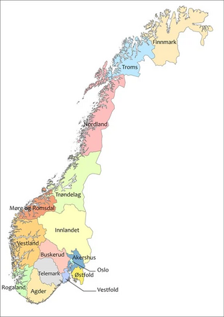
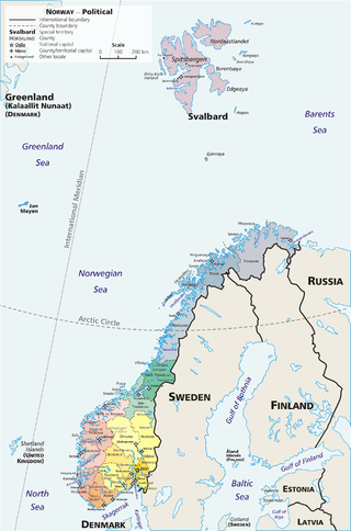
There are 15 counties in Norway. The 15 counties are administrative regions that are the first-level administrative divisions of Norway. The counties are further subdivided into 357 municipalities. The island territories of Svalbard and Jan Mayen are outside the county divisions and they are ruled directly from the national level. The capital city of Oslo is both a county and a municipality.

Trøndelag (Urban East Norwegian:[ˈtrœ̂ndəˌlɑːɡ]; or Trööndelage is a county and coextensive with the Trøndelag region in the central part of Norway. It was created in 1687, then named Trondhjem County ; in 1804 the county was split into Nord-Trøndelag and Sør-Trøndelag by the King of Denmark-Norway, and the counties were reunited in 2018 after a vote of the two counties in 2016.

Dovrefjell is a mountain range in Central Norway that forms a natural barrier between Eastern Norway and Trøndelag. The mountain range is located in Innlandet, Møre og Romsdal, and Trøndelag counties in Norway. As a result of its central location, its valleys and passes have been heavily trafficked during and probably preceding historical times. Several mountain inns were established in the Middle Ages to house pilgrims traveling through Dovrefjell to Trondheim, and there are even ruins of an old leper colony in the northern area of it.
Dovrefjell–Sunndalsfjella National Park is a National Park in Norway. It was established in 2002 to replace and enlarge the former Dovrefjell National Park which had been established in 1974. The park occupies 1,693 square kilometres (654 sq mi) and encompasses areas in three Norwegian counties: Innlandet, Trøndelag, and Møre og Romsdal and includes large parts of the mountain range of Dovrefjell along with the Sunndalsfjella mountains. Together with the National Park, there are eight landscape protected areas and two biotope protected areas that were established adjacent to the park in 2002, comprising a total protected area of 4,366 square kilometres (1,686 sq mi). The park itself lies within the municipalities of Dovre and Lesja, Oppdal municipality, and Sunndal and Molde municipalities.

Norwegian dialects are commonly divided into four main groups, 'Northern Norwegian', 'Central Norwegian', 'Western Norwegian', and 'Eastern Norwegian'. Sometimes 'Midland Norwegian' and/or 'South Norwegian' are considered fifth or sixth groups.
Western Norway is the region along the Atlantic coast of southern Norway. It consists of the counties Rogaland, Vestland, and Møre og Romsdal. The region has no official or political-administrative function. The region has a population of approximately 1.4 million people. The largest city is Bergen and the second-largest is Stavanger. Historically the regions of Agder, Vest-Telemark, Hallingdal, Valdres, and northern parts of Gudbrandsdal have been included in Western Norway.
Eastern Norway is the geographical region of the south-eastern part of Norway. It consists of the counties Oslo, Akershus, Vestfold, Østfold, Buskerud, Telemark, and Innlandet.

Nidaros is a diocese in the Lutheran Church of Norway. It covers Trøndelag county in Central Norway and its cathedral city is Trondheim, which houses the well-known Nidaros Cathedral. Since 10 September 2017, the Bishop of Nidaros is Herborg Finnset. The Bishop Preses, currently Olav Fykse Tveit is also based at the Nidaros Cathedral. The diocese is divided into nine deaneries (prosti). While the Bishop Preses holds episcopal responsibility within the Nidaros domprosti (deanery) in Trondheim, the Bishop of Nidaros holds episcopal authority of the other eight deaneries as well as the language based parish of the Southern Sámi.

The Pilgrim's Route, (Pilegrimsleden) also known as St. Olav's Way or the Old Kings' Road, was a pilgrimage route to the Nidaros Cathedral in Trondheim, Norway, the site of the medieval tomb of St. Olav. The main route is approximately 640 kilometres (400 mi) long. It starts in the ancient part of Oslo and heads north along the lake Mjøsa, up the Gudbrandsdal valley, over the Dovrefjell mountains, and down the Oppdal and Gauldalen valleys to end at the Nidaros Cathedral.

The petty kingdoms of Norway were the entities from which the later Kingdom of Norway was founded. Before the unification of Norway in 872 and during the period of fragmentation after King Harald Fairhair's death, Norway was divided in several small kingdoms. Some could have been as small as a cluster of villages, and others comprised several of today's counties.
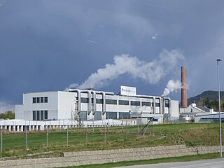
Ranheim Papirfabrikk AS was a Norwegian industrial company, which ran a paper factory with the same name at Ranheim, Trondheim, Norway.
Norway is commonly divided into five major geographical regions. These regions are purely geographical and cultural, and have no administrative purpose. However, in 2017 the government decided to abolish the current counties of Norway and to replace them with fewer, larger administrative regions. The first of these new areas came into existence on 1 January 2018, when Nord-Trøndelag and Sør-Trøndelag merged to form Trøndelag.

Sør-Trøndelag was a county comprising the southern portion of the present-day Trøndelag county in Norway. It bordered the old Nord-Trøndelag county as well as the counties of Møre og Romsdal, Oppland, and Hedmark. To the west is the Norwegian Sea, and to the east is Jämtland in Sweden. The county was separated into a northern and southern part by the Trondheimsfjord. Slightly over 200,000 of the county's population lives in the city of Trondheim and its suburbs. The Norwegian dialect of the region is Trøndersk.
Norway has two official names: Norge in Bokmål and Noreg in Nynorsk. The English name Norway comes from the Old English word Norþweg mentioned in 880, meaning "northern way" or "way leading to the north", which is how the Anglo-Saxons referred to the coastline of Atlantic Norway similar to leading theory about the origin of the Norwegian language name. The Anglo-Saxons of Britain also referred to the kingdom of Norway in 880 as Norðmanna land.

Kingo's hymnal, originally titled Dend Forordnede Ny Kirke-Psalme-Bog, is a hymnal that was approved by royal decree for use in all churches in Denmark–Norway in 1699. The hymnal contains 86 hymns by the bishop of Odense, Thomas Kingo. It also bears Kingo's name on the title page because the selection was made based on a hymnal that Kingo had edited ten years earlier.

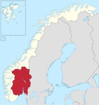
Innlandet is a county in Norway. It was created on 1 January 2020 with the merger of the old counties of Oppland and Hedmark. The new county has an area of 52,113 square kilometres (20,121 sq mi), making it the largest county in Norway after Troms og Finnmark was split up in 2024.
References
- ↑ Imsen, S. and Winge, H. (eds.): Norsk historisk leksikon, Cappelen Akademisk Forlag, Second edition, 1999
- 1 2 Helle, Knut: «Ei soge om Vestlandet». Chapter 1, volume 1 of Vestlandets historie (edited by Knut Helle). Bergen: Vigmostad og Bjørke, 2006.
- 1 2 Krag, Claus, 2003: "The early unification of Norway." In Knut Helle (red.): The Cambridge history of Scandinavia 1. Prehistory to 1520. Cambridge: Cambridge University Press. 184-201.
- ↑ Orning, Hans Jacob: «En vestlandskonge?» Klassekampen, 18. februar 2013.