North Carolina Highway 144

Last updated

NC 144.svg

North Carolina Highway 144
Old Wire Road
NC 144 map.svg
Route information
Maintained by NCDOT
Length 12.0 mi [1] (19.3 km)
Existed 2002 – present
Major junctions
West endFuture plate blue.svgNo image wide.svg
I-74.svgUS 74.svg Future I74 / US 74 in Laurel Hill
East endUS 401.svg US 401 in Wagram
Location
Counties Scotland
Highway system
NC 143.svg NC 143 NC 145 NC 145.svg

North Carolina Highway 144 (NC 144) is a primary state highway in the U.S. state of North Carolina. It runs from Laurel Hill to Wagram, in the North Carolina Sandhills.

A state highway, state road, or state route is usually a road that is either numbered or maintained by a sub-national state or province. A road numbered by a state or province falls below numbered national highways in the hierarchy. Roads maintained by a state or province include both nationally numbered highways and un-numbered state highways. Depending on the state, "state highway" may be used for one meaning and "state road" or "state route" for the other.

North Carolina State of the United States of America

North Carolina is a state in the southeastern region of the United States. It borders South Carolina and Georgia to the south, Tennessee to the west, Virginia to the north, and the Atlantic Ocean to the east. North Carolina is the 28th-most extensive and the 9th-most populous of the U.S. states. The state is divided into 100 counties. The capital is Raleigh, which along with Durham and Chapel Hill is home to the largest research park in the United States. The most populous municipality is Charlotte, which is the second-largest banking center in the United States after New York City.

Laurel Hill, Scotland County, North Carolina Unincorporated community in North Carolina, United States

Laurel Hill is a census-designated place and unincorporated community in Scotland County, North Carolina, United States. It is located northwest of Laurinburg, and southeast of Old Hundred, a neighboring community.

Contents

Route description

NC 144 in Laurel Hill NC 144 in Laurel Hill.JPG
NC 144 in Laurel Hill

A two-lane rural highway, it traverses 12 miles (19 km) from Laurel Hill to Wagram. NC 144 provides an alternate route for U.S. Route 74 (US 74) traffic to reach US 401 while avoiding Laurinburg. [1]

U.S. Route 74 (US 74) is an east–west United States highway that runs for 515 miles (829 km) from Chattanooga, Tennessee to Wrightsville Beach, North Carolina. Predominantly in North Carolina, it serves as an important highway from the mountains to the sea, connecting the cities of Asheville, Charlotte and Wilmington.

U.S. Route 401 highway in the United States

U.S. Route 401 (US 401) is a north–south United States highway, a spur of U.S. Route 1, that travels along the Fall Line from Sumter, South Carolina to Interstate 85 near Wise, North Carolina.

Laurinburg, North Carolina City in North Carolina, United States

Laurinburg is a city in and the county seat of Scotland County, North Carolina, United States. Located in southern North Carolina near the South Carolina border, Laurinburg is southwest of Fayetteville and is home to St. Andrews University. The Laurinburg Institute, a historically African-American school, is also located in Laurinburg. The population at the 2010 Census was 15,962 people.

History

Established in February 2002 as a new primary route connecting Laurel Hill and Wagram, unchanged since. This is the third incarnation of NC 144.

The first NC 144 was established in 1921 as an original state highway, running from NC 14 (now NC 86) in Prospect Hill to NC 13 in Roxboro. In 1925 it was extended west as new routing to NC 62. In 1932 NC 144 was extended northeast as new routing ending at NC 562 (now NC 96) in Virgilina. In 1936, was extended southwest as new routing to NC 61. In 1940 NC 144 was renumbered as NC 62 from NC 61 to Pleasant Grove and NC 49, from Pleasant Grove to Virgilina.

North Carolina Highway 14 highway in North Carolina

North Carolina Highway 14 (NC 14) is a primary state highway in the U.S. state of North Carolina entirely in Rockingham County. It links US 29/US 158 near Reidsville with the city of Eden. From Eden, it continues north concurrent with NC 87 to the Virginia state line where the road continues as Virginia State Route 87 (SR 87).

North Carolina Highway 86 highway in North Carolina

North Carolina Highway 86 (NC 86) is a primary state highway in the U.S. state of North Carolina that runs north and south through Orange and Caswell Counties from Chapel Hill to the Virginia state line at Danville, Virginia. The highway primarily links up the towns of Chapel Hill, Hillsborough, and Yanceyville, along with providing a route between Chapel Hill and Virginia. Between Chapel Hill and Hillsborough, NC 86 serves as an alternative to I-40.

Prospect Hill, North Carolina Unincorporated community in North Carolina, United States

Prospect Hill is a small unincorporated community in Hightowers Township, Caswell County, North Carolina, United States. It lies at the intersection of North Carolina Highways 49 and 86. It is in extreme southeastern Caswell County.

Junction list

The entire route is in Scotland County.

Locationmi [1] kmDestinationsNotes
Laurel Hill 0.00.0Future plate blue.svgNo image wide.svg
I-74.svgUS 74.svg Future I74 / US 74  Rockingham, Laurinburg
5.89.3US 15.svgUS 501.svg US 15 / US 501  Aberdeen, Laurinburg
Wagram 12.019.3US 401.svg US 401  Raeford, Laurinburg
1.000 mi = 1.609 km; 1.000 km = 0.621 mi

Related Research Articles

North Carolina Highway 24 highway in North Carolina

North Carolina Highway 24 (NC 24) is the longest primary state highway in the U.S. state of North Carolina. Traveling east–west between the Charlotte metropolitan area and the Crystal Coast, connecting the cities of Charlotte, Fayetteville, Jacksonville and Morehead City.

North Carolina Highway 51 highway in North Carolina

North Carolina Highway 51 (NC 51) is a primary state highway in the U.S. state of North Carolina entirely in Mecklenburg County. It connects the towns of Pineville, Matthews and Mint Hill.

North Carolina Highway 7 highway in North Carolina

North Carolina Highway 7 (NC 7) is a primary state highway in the U.S. state of North Carolina. Entirely within Gaston County, it connects the towns of Lowell, McAdenville, and Belmont with the city of Gastonia.

North Carolina Highway 610 highway in North Carolina

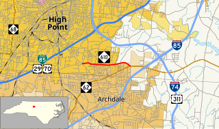
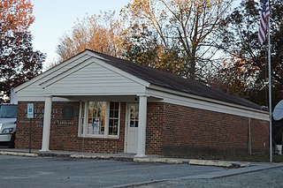
North Carolina Highway 610 (NC 610) is a 2.1-mile-long (3.4 km) primary state highway in the U.S. state of North Carolina. The highway connects Main Street in southern High Point with North Carolina Highway 62 east of Archdale. The highway provides indirect access between High Point and Interstate 85/Interstate 74. The current highway was established in 1930 and its routing has remained unchanged since.

North Carolina Highway 49 highway in North Carolina

North Carolina Highway 49 (NC 49) is a primary state highway in the U.S. state of North Carolina. It traverses much of the Piedmont region of North Carolina.

North Carolina Highway 96 highway in North Carolina

North Carolina Highway 96 (NC 96) is a 112-mile-long (180 km) primary state highway in the U.S. state of North Carolina. It is a predominantly rural highway that travels north-south, from NC 55, west of Newton Grove, to the Virginia state line near Virgilina, Virginia, where it continues on as Virginia State Route 96. It also connects the cities of Smithfield, Selma, Zebulon, Youngsville and Oxford.

Virginia State Route 96 highway in Virginia

State Route 96 is a primary state highway in the U.S. state of Virginia. Known for most of its length as Virgilina Road, the state highway runs 7.83 miles (12.60 km) from U.S. Route 501 near Cluster Springs east to the North Carolina state line in Virgilina. In Virgilina, SR 96 runs concurrently with SR 49 south to the border, where the highways continue as North Carolina Highway 96 and NC 49, respectively.

North Carolina Highway 207 highway in North Carolina

North Carolina Highway 207 (NC 207) is a primary state highway in the U.S. state of North Carolina. It is entirely in the boundaries of Union County and serves to connect the city of Monroe to the city of Pageland, South Carolina, at the South Carolina state line via SC 207.

North Carolina Highway 62 highway in North Carolina

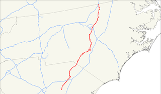
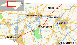
North Carolina Highway 62 (NC 62) is a primary state highway in the U.S. state of North Carolina. Primarily in the Piedmont Triad, it runs from NC 109 in Thomasville northeast to the Virginia state line in Milton.

North Carolina Highway 205 highway in North Carolina

North Carolina Highway 205 (NC 205) is a primary state highway in the U.S. state of North Carolina. It traverses 22 miles (35 km) in Stanly and Union Counties.

North Carolina Highway 68 highway in North Carolina

North Carolina Highway 68 (NC 68) is a north–south state highway in North Carolina. It serves as a connector between Interstate 40 (I-40)/ US 421 and Piedmont Triad International Airport. On its routing from Thomasville to Stokesdale, NC 68 passes through urban High Point, the western outskirts of Greensboro, and the town of Oak Ridge. The segment from just north of the I-40/US 421 interchange to Pleasant Ridge Road in Guilford County is a limited access freeway.

North Carolina Highway 141 highway in North Carolina

North Carolina Highway 141 (NC 141) is a primary state highway in the U.S. state of North Carolina. It serves to connect the Peachtree community, located in the Valley River Mountains, with Marble and Murphy.

North Carolina Highway 48 highway in North Carolina

North Carolina Highway 48 (NC 48) is a primary state highway in the U.S. state of North Carolina that principally connects the cities of Rocky Mount and Roanoke Rapids. The route offers an alternative to US 301 and I-95.

North Carolina Highway 113 highway in North Carolina

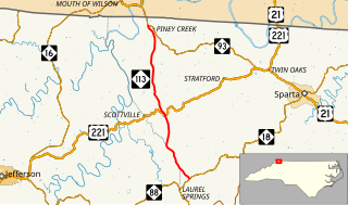
North Carolina Highway 113 is a primary state highway in the U.S. state of North Carolina. It runs from NC 18 in the community of Laurel Springs, to NC 93 in the community of Piney Creek.

North Carolina Highway 88 highway in North Carolina

North Carolina Highway 88 (NC 88) is a 41.3-mile-long (66.5 km) primary state highway in the U.S. state of North Carolina. Primarily in the High Country, it runs from the Tennessee state line near Trade east to NC 18 in Laurel Springs.

North Carolina Highway 61 highway in North Carolina

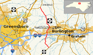
North Carolina Highway 61 (NC 61) is a primary state highway in the U.S. state of North Carolina. It serves as the main north–south highway in eastern Guilford County, connecting Whitsett and Gibsonville.

North Carolina Highway 218 (NC 218) is a primary state highway in the U.S. state of North Carolina. The highway runs east–west from Mint Hill to Polkton.

North Carolina Highway 79 highway in North Carolina

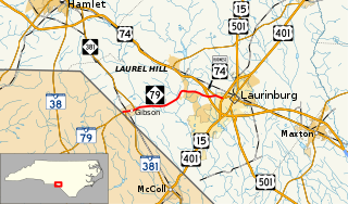
North Carolina Highway 79 (NC 79) is a primary state highway in the U.S. state of North Carolina running from the South Carolina border at Gibson to U.S. Routes US 15, US 401, and US 501 in Laurinburg.

North Carolina Highway 161 highway in North Carolina

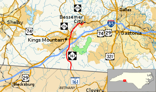
North Carolina Highway 161 (NC 161) is a primary state highway in the U.S. state of North Carolina that connects the city of Kings Mountain, North Carolina to Bessemer City, North Carolina and York, South Carolina.

North Carolina Highway 308 highway in North Carolina

North Carolina Highway 308 (NC 308) is a primary state highway in the U.S. state of North Carolina. It serves mainly to connect the city of Windsor to communities and towns in eastern Bertie County.

References

KML file (edithelp)
KML is from Wikidata
  1. 1 2 3 Google (April 12, 2016). "North Carolina Highway 144" (Map). Google Maps . Google. Retrieved April 12, 2016.