North Carolina Highway 34

Last updated

NC 34.svg

North Carolina Highway 34
NC 34 map.svg
Route information
Maintained by NCDOT
Length 9.2 mi [1] (14.8 km)
Existed 1970s [2] – present
Major junctions
South endUS 158.svg US 158 near Camden
North endNC 168.svg NC 168 near Currituck
Location
Counties Camden, Currituck
Highway system
NC 33.svg NC 33 NC 35 NC 35.svg

North Carolina Highway 34 (NC 34) is a short primary state highway in the U.S. state of North Carolina. Spanning a distance of 9.177 miles (14.769 km), the route passes through a few small unincorporated communities in eastern North Carolina's Inner Banks near Elizabeth City.

A state highway, state road, or state route is usually a road that is either numbered or maintained by a sub-national state or province. A road numbered by a state or province falls below numbered national highways in the hierarchy. Roads maintained by a state or province include both nationally numbered highways and un-numbered state highways. Depending on the state, "state highway" may be used for one meaning and "state road" or "state route" for the other.

North Carolina State of the United States of America

North Carolina is a state in the southeastern region of the United States. It borders South Carolina and Georgia to the south, Tennessee to the west, Virginia to the north, and the Atlantic Ocean to the east. North Carolina is the 28th-most extensive and the 9th-most populous of the U.S. states. The state is divided into 100 counties. The capital is Raleigh, which along with Durham and Chapel Hill is home to the largest research park in the United States. The most populous municipality is Charlotte, which is the second-largest banking center in the United States after New York City.

Inner Banks neologism without historical precedent used by developers and tourism promoters to describe the inland coastal region of eastern North Carolina

The Inner Banks is a neologism made up by developers and tourism promoters to describe the inland coastal region of eastern North Carolina. Without historical precedent, the term "Inner Banks" is an early 21st-century construct that is part of an attempt to rebrand the mostly agrarian coastal plain east of I-95 as a more attractive region for visitors and retirees.

Contents

Route description

The route's southern terminus is the intersection with US 158 in the community of Belcross, in Camden County. From there, it progresses in a general northeastern direction through Hastings Corners, where it also becomes known as Shawboro Road. After uniting with Indiantown Road, NC 34 continues north to its northern terminus at NC 168 in Sligo, Currituck County. [3]

U.S. Route 158 highway in the United States

U.S. Route 158 is an east–west United States highway that runs for 350 miles (560 km) from Mocksville to Whalebone Junction in Nags Head, entirely in the state of North Carolina.

Camden County, North Carolina County in the United States

Camden County is a county located in the American state of North Carolina. As of the 2010 census, the population was 9,980, making it the fourth-least populous county in North Carolina. Its county seat is Camden.

North Carolina Highway 168 highway in North Carolina

North Carolina Highway 168 (NC 168) is a primary state highway in the U.S. state of North Carolina. Known as Caratoke Highway, the state highway runs 18.28 miles (29.42 km) from US 158 in Barco north to the Virginia state line in Moyock, where the highway continues as Virginia State Route 168 (SR 168) toward Norfolk, Virginia. NC 168 forms part of the primary north–south highway of Currituck County, where it provides access to the county seat of Currituck. The state highway also provides a crucial link for traffic between the Hampton Roads region of Virginia and the Outer Banks.

History

Over the years since the 1930s, NC 34 has occupied a variety of routes in the northeastern part of North Carolina, including current-day NC 168, NC 343, NC 344, and US 158. [2]

North Carolina Highway 343 highway in North Carolina

North Carolina Highway 343 (NC 343) is a primary state highway in the U.S. state of North Carolina. It serves to connect the county seat of Camden with both the north and south ends of Camden County.

North Carolina Highway 344 highway in North Carolina

North Carolina Highway 344 (NC 344) is a primary state highway in the U.S. state of North Carolina. It serves to connect Elizabeth City with communities in southern Pasquotank County.

Major intersections

CountyLocationmi [1] kmDestinationsNotes
Camden Camden 0.00.0US 158.svg US 158  Nags Head, Elizabeth City Southern terminus
Currituck Currituck 9.214.8NC 168.svg NC 168  Moyock, Currituck Sound Ferry Northern terminus
1.000 mi = 1.609 km; 1.000 km = 0.621 mi

Related Research Articles

North Carolina Highway 24 highway in North Carolina

North Carolina Highway 24 (NC 24) is the longest primary state highway in the U.S. state of North Carolina. Traveling east–west between the Charlotte metropolitan area and the Crystal Coast, connecting the cities of Charlotte, Fayetteville, Jacksonville and Morehead City.

North Carolina Highway 86 highway in North Carolina

North Carolina Highway 86 (NC 86) is a primary state highway in the U.S. state of North Carolina that runs north and south through Orange and Caswell Counties from Chapel Hill to the Virginia state line at Danville, Virginia. The highway primarily links up the towns of Chapel Hill, Hillsborough, and Yanceyville, along with providing a route between Chapel Hill and Virginia. Between Chapel Hill and Hillsborough, NC 86 serves as an alternative to I-40.

North Carolina Highway 615 highway in North Carolina

North Carolina Highway 615 (NC 615) is a primary state highway in the U.S. state of North Carolina. It connects Knotts Island with mainland North Carolina via the Currituck–Knotts Island Ferry.

North Carolina Highway 47 highway in North Carolina

North Carolina Highway 47 (NC 47) is a primary state highway in the U.S. state of North Carolina. It travels east–west through Davidson and Randolph counties; connecting the town of Denton with nearby Lexington and Asheboro.

North Carolina Highway 150 highway in North Carolina

North Carolina Highway 150 (NC 150) is a primary state highway in the U.S. state of North Carolina. It serves the Foothills and Piedmont Triad areas of the state, connecting the cities of Shelby, Mooresville, Salisbury and Winston-Salem.

North Carolina Highway 22 highway in North Carolina

North Carolina Highway 22 is a North Carolina state highway that runs in the central-north part of the state. It runs between Southern Pines and Climax. The route is signed north–south, and is 59 miles (95 km) in length.

North Carolina Highway 136 highway in North Carolina

North Carolina Highway 136 (NC 136) is a 2.22-mile (3.57 km) North Carolina state highway that runs entirely within Currituck County. It is a short spur of U.S. Route 158, connecting the U.S. Highway to the small unincorporated community of Poplar Branch. The route's eastern terminus is at a boat launch on the Currituck Sound. Prior to 2002, NC 136's current alignment was known as NC 3. In 2002, the numbering of this road and of what was then NC 136 which was located in Iredell and Cabarrus counties swapped to place NC 3 near the home of Dale Earnhardt, a deceased NASCAR driver from Kannapolis who drove the #3 car.

North Carolina Highway 46 highway in North Carolina

North Carolina Highway 46 (NC 46) is a primary state highway in the U.S. state of North Carolina; it is entirely in Northampton County. The route primarily connects the communities on the north side of Roanoke Rapids Lake and Lake Gaston, as well as the north side of the Roanoke River in the county.

North Carolina Highway 39 highway in North Carolina

North Carolina Highway 39 (NC 39) is a primary state highway in the U.S. state of North Carolina. Traveling north–south, it connects the cities of Selma, Louisburg and Henderson, in the Research Triangle area.

North Carolina Highway 37 highway in North Carolina

North Carolina Highway 37 (NC 37) is a primary state highway in the northeastern part of the U.S. state of North Carolina. Traveling north–south, it serves as a connector route from U.S. Route 64 (US 64) to Hertford and from US 13 to Gatesville.

North Carolina Highway 94 highway in North Carolina

North Carolina Highway 94 (NC 94) is a primary state highway in the U.S. state of North Carolina. It runs from Hyde County in Swan Quarter to Chowan County near Edenton.

North Carolina Highway 141 highway in North Carolina

North Carolina Highway 141 (NC 141) is a primary state highway in the U.S. state of North Carolina. It serves to connect the Peachtree community, located in the Valley River Mountains, with Marble and Murphy.

North Carolina Highway 65 highway in North Carolina

North Carolina Highway 65 (NC 65) is a primary state highway in the U.S. state of North Carolina. Traveling east–west within the Piedmont Triad, it connects the towns of Rural Hall, Walnut Cove, Stokesdale and Wentworth with the city of Reidsville.

North Carolina Highway 125 highway in North Carolina

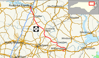
North Carolina Highway 125 (NC 125) is a primary state highway in the U.S. state of North Carolina that serves the communities of Williamston, Hamilton, Oak City, Hobgood, Scotland Neck, Halifax, and Roanoke Rapids.

North Carolina Highway 304

North Carolina Highway 304 (NC 304) is a primary state highway in the U.S. state of North Carolina. The two-lane coastal highway is 15.2-mile-long (24.5 km) and connects Bayboro with communities in northeastern Pamlico County.

North Carolina Highway 305

North Carolina Highway 305 (NC 305) is a primary state highway in the U.S. state of North Carolina. NC 305 runs from US 13 north of Windsor to NC 186 in Seaboard. NC 305 is an original state highway and appeared on the 1936 official map of North Carolina from Seaboard to Aulander. NC 305 has an average of 1663 cars per day on the highway.

References

Route map: Google

KML file (edithelp)
KML is from Wikidata
  1. 1 2 "NCDOT GIS Data Layers". North Carolina Department of Transportation. 2012. Retrieved December 28, 2012.
  2. 1 2 NCRoads Annex - NC 34 [ self-published source ] Archived May 8, 2007, at the Wayback Machine.
  3. Google (February 11, 2016). "North Carolina Highway 34" (Map). Google Maps . Google. Retrieved February 11, 2016.