North Carolina Highway 905

Last updated

NC 905.svg

North Carolina Highway 905
NC 905 map.svg
Route information
Maintained by NCDOT
Length20.9 mi [1] (33.6 km)
Existed1958–present
Major junctions
South endSouth Carolina 905.svg SC 905 at the South Carolina state line
North endNC 130.svg NC 130 in Pleasant Plains
Location
Counties Columbus
Highway system
NC 904.svg NC 904 NC 906 NC 906.svg

North Carolina Highway 905 (NC 905) is a primary state highway in the U.S. state of North Carolina. It serves as part of an alternate route between Whiteville and Conway, South Carolina, through southeastern Columbus County.

A state highway, state road, or state route is usually a road that is either numbered or maintained by a sub-national state or province. A road numbered by a state or province falls below numbered national highways in the hierarchy. Roads maintained by a state or province include both nationally numbered highways and un-numbered state highways. Depending on the state, "state highway" may be used for one meaning and "state road" or "state route" for the other.

North Carolina State of the United States of America

North Carolina is a state in the southeastern region of the United States. It borders South Carolina and Georgia to the south, Tennessee to the west, Virginia to the north, and the Atlantic Ocean to the east. North Carolina is the 28th-most extensive and the 9th-most populous of the U.S. states. The state is divided into 100 counties. The capital is Raleigh, which along with Durham and Chapel Hill is home to the largest research park in the United States. The most populous municipality is Charlotte, which is the second-largest banking center in the United States after New York City.

Whiteville, North Carolina City in North Carolina, United States

Whiteville is a city in Columbus County, North Carolina, United States. The population was 5,394 at the 2010 census. It is the largest city in Columbus County and is the county seat.

Contents

Route description

NC 905 is a two-lane rural highway that begins at the South Carolina line and South Carolina Highway 905 (SC 905) in Olyphic. Traveling north, it connects with NC 904 in Pireway. After its six-tenths-mile (0.97 km) concurrency with NC 904, it continues solo for 15.1 miles (24.3 km), connecting the communities of Bug Hill and Nakina, until it ends at NC 130 in Pleasant Plains. [1]

South Carolina Highway 905 highway in South Carolina

South Carolina Highway 905 is a state highway in Horry County. It starts from Conway to the South Carolina state line continuing on to North Carolina Highway 905. It is parallel to the Waccamaw River.

Olyphic, North Carolina, is an unincorporated community in Columbus County, North Carolina, south of Pireway. It lies on North Carolina Highway 905, north of the South Carolina Border. Its elevation above sea level is reported as 39 feet or 12 meters.

North Carolina Highway 904 highway in North Carolina

North Carolina Highway 904 (NC 904) is a primary state highway in the U.S. state of North Carolina. The highway parallels the North Carolina-South Carolina border as it connects Fair Bluff, Tabor City, Sunset Beach, and Ocean Isle Beach.

The route is part of a larger alternate route to U.S. Route 701 between Whiteville, North Carolina and Conway, South Carolina via NC 130 and SC 905. From 1958 to 2016, it was the highest number signed as a primary route in North Carolina.

U.S. Route 701 is an auxiliary route of US 1 in the U.S. states of South Carolina and North Carolina. The U.S. Highway runs 171.45 miles (275.92 km) from US 17 and US 17 Alternate in Georgetown, South Carolina north to US 301, North Carolina Highway 96, and Interstate 95 (I-95) near Four Oaks, North Carolina. US 701 serves the Pee Dee region of South Carolina and the southern and central portions of Eastern North Carolina. The highway connects Georgetown and Conway in South Carolina with the North Carolina cities of Whiteville, Elizabethtown, Clinton, and a short distance north of its terminus, Smithfield. US 701 has four business routes in North Carolina, including those through Tabor City, Whiteville, Clarkton, and Clinton.

History

NC 905 was established around 1958 as an extension of SC 905, which had ended at the state line since around 1942. Its route from Olyphic to Pleasant Plains has remained unchanged since. [2]

Junction list

The entire route is in Columbus County.

Locationmi [1] kmDestinationsNotes
Olyphic 0.00.0South Carolina 905.svg SC 905 south Longs Continuation into South Carolina
Pireway 4.57.2NC 904.svg NC 904 east Longwood East end of NC 904 overlap
5.18.2NC 904.svg NC 904 west Tabor City West end of NC 904 overlap
Pleasant Plains 20.933.6NC 130.svg NC 130  Shallotte, Whiteville
1.000 mi = 1.609 km; 1.000 km = 0.621 mi

Related Research Articles

North Carolina Highway 51 highway in North Carolina

North Carolina Highway 51 (NC 51) is a primary state highway in the U.S. state of North Carolina entirely in Mecklenburg County. It connects the towns of Pineville, Matthews and Mint Hill.

North Carolina Highway 83 highway in North Carolina

North Carolina Highway 83 (NC 83) is a primary state highway in the U.S. state of North Carolina. It serves to connect the towns of Maxton and Clio, South Carolina.

North Carolina Highway 211 highway in North Carolina

North Carolina Highway 211 (NC 211) is a 162.5-mile-long (261.5 km) primary state highway in the U.S. state of North Carolina. It traverses mostly through the Sandhills and Coastal Plain regions of the state; connecting the cities of Candor, Aberdeen, Raeford, Lumberton, Bladenboro, and Southport.

North Carolina Highway 49 highway in North Carolina

North Carolina Highway 49 (NC 49) is a primary state highway in the U.S. state of North Carolina. It traverses much of the Piedmont region of North Carolina.

North Carolina Highway 87 highway in North Carolina

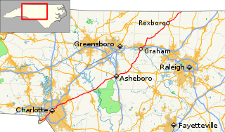
North Carolina Highway 87 (NC 87) is a primary state highway in the U.S. state of North Carolina. NC 87 begins in the Atlantic coastal town of Southport and crosses into Virginia at the Virginia state line five miles (8 km) north of Eden in Rockingham County. At 240 miles (390 km) in length, NC 87 is the second longest state highway in the U.S. state of North Carolina. Labeled as a north–south route, NC 87 travels along a relatively straight southeast–northwest path, connecting Cape Fear region with the Piedmont and connecting the cities of Fayetteville, Sanford, and Burlington.

North Carolina Highway 214 highway in North Carolina

North Carolina Highway 214 (NC 214) is a primary state highway in the U.S. state of North Carolina; it is entirely in Columbus County.

North Carolina Highway 200 highway in North Carolina

North Carolina Highway 200 (NC 200) is a primary state highway in the U.S. state of North Carolina. The highway runs north–south from the South Carolina state line near the community of JAARS, to US 601 near Concord.

North Carolina Highway 130 highway in North Carolina

North Carolina Highway 130 (NC 130) is a primary state highway in the U.S. state of North Carolina. The highway serves the towns and rural communities in southern Robeson County, acts as a direct route between Whiteville and Shallotte through the Green Swamp, and provides access to Holden Beach.

North Carolina Highway 242 highway in North Carolina

North Carolina Highway 242 (NC 242) is a primary state highway in the U.S. state of North Carolina. It traverses from Cerro Gordo to Benson, connecting the cities of Bladenboro, Elizabethtown, and Roseboro.

U.S. Route 76 in North Carolina highway in North Carolina

U.S. Highway 76 (US 76) is an east–west road in North Carolina running from the South Carolina state line to Wrightsville Beach. US 76 runs concurrently with US 74 for 52 miles (84 km) of the entire route in North Carolina. US 76 was first designated in North Carolina between late 1934 and 1935.

North Carolina Highway 179 highway in North Carolina

North Carolina Highway 179 is a primary state highway in the U.S. state of North Carolina. It runs from the South Carolina state line, near Little River, to Shallotte.

North Carolina Highway 281 highway in North Carolina

North Carolina Highway 281 (NC 281) is a primary state highway in the U.S. state of North Carolina. The highway runs north–south, connecting communities in western Jackson County and scenic areas of southwest Transylvania County. It is the only North Carolina state highway that changes numbers when crossing into South Carolina.

North Carolina Highway 161 highway in North Carolina

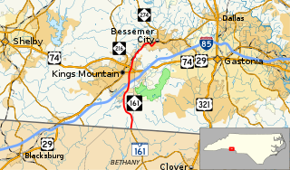
North Carolina Highway 161 (NC 161) is a primary state highway in the U.S. state of North Carolina that connects the city of Kings Mountain, North Carolina to Bessemer City, North Carolina and York, South Carolina.

South Carolina Highway 151 highway in South Carolina

South Carolina Highway 151 (SC 151) is a primary state highway in the U.S. state of South Carolina. Known as "the road to the beach", by many residents of the Charlotte metropolitan area due to it being the most direct route to the Grand Strand, it connects the Charlotte metropolitan area to Darlington, Florence, and the Grand Strand.

North Carolina Highway 131

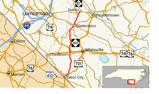
North Carolina Highway 131 (NC 131) is a primary state highway in the U.S. state of North Carolina. It connects the city of Bladenboro to Fayetteville, via NC 87, and Whiteville, via US 701.

North Carolina Highway 410

North Carolina Highway 410 (NC 410) is a primary state highway in the U.S. state of North Carolina. It serves as the central north–south highway in Columbus and Bladen Counties.

North Carolina Highway 710

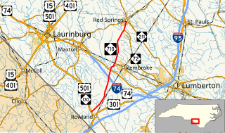
North Carolina Highway 710 (NC 710) is a primary state highway in the U.S. state of North Carolina. It connects the town of Pembroke to Interstate 74 (I-74) and U.S. Route 74 and the nearby towns of Red Springs and Rowland.

Several special routes of U.S. Route 701 exist, from South Carolina to North Carolina. In order from south to north, separated by type, they are as follows.

References

  1. 1 2 3 Google (February 14, 2016). "North Carolina Highway 905" (Map). Google Maps . Google. Retrieved February 14, 2016.
  2. North Carolina Highway System (PDF) (Map). Cartography by NCSHC. North Carolina State Highway Commission. 1960. Retrieved February 14, 2016.
KML file (edithelp)
    KML is from Wikidata