
Somerset is a county in South West England which borders Gloucestershire and Bristol to the north, Wiltshire to the east, Dorset to the south-east and Devon to the south-west. It is bounded to the north and west by the Severn Estuary and the Bristol Channel, its coastline facing southeastern Wales. Its traditional border with Gloucestershire is the River Avon. Somerset's county town is Taunton.

The River Parrett flows through the counties of Dorset and Somerset in South West England, from its source in the Thorney Mills springs in the hills around Chedington in Dorset. Flowing northwest through Somerset and the Somerset Levels to its mouth at Burnham-on-Sea, into the Bridgwater Bay nature reserve on the Bristol Channel, the Parrett and its tributaries drain an area of 660 square miles (1,700 km2) – about 50 per cent of Somerset's land area, with a population of 300,000.

The Somerset Levels are a coastal plain and wetland area of Somerset, England, running south from the Mendips to the Blackdown Hills.
Sedgemoor is a low-lying area of land in Somerset, England. It lies close to sea level south of the Polden Hills, historically largely marsh. The eastern part is known as King's Sedgemoor, and the western part West Sedgemoor. Sedgemoor is part of the area now known as the Somerset Levels and Moors. Historically the area was known as the site of the Battle of Sedgemoor.
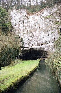
The River Axe is a river in South West England. The river is formed by water entering swallets in the limestone and rises from the ground at Wookey Hole Caves in the Mendip Hills in Somerset, and runs through a V-shaped valley. The geology of the area is limestone and the water reaches Wookey Hole in a series of underground channels that have eroded through the soluble limestone. The river mouth is in Weston Bay on the Bristol Channel.
The Glastonbury Canal ran for approximately 14 miles (23 km) through two locks from Glastonbury to Highbridge in Somerset, England, where it entered the River Parrett and from there the Bristol Channel. The canal was authorised by Parliament in 1827 and opened in 1834. It was operated by The Glastonbury Navigation & Canal Company. Most of it was abandoned as a navigation in 1854, when a railway was built along the towpath.

The River Cary is a river in Somerset, England. It is sourced from the Park Pond in Castle Cary and flows towards the southwest.

Somerset is a rural county in the southwest of England, covering 4,171 square kilometres (1,610 sq mi). It is bounded on the north-west by the Bristol Channel, on the north by Bristol and Gloucestershire, on the north-east by Wiltshire, on the south-east by Dorset, and on the south west and west by Devon. It has broad central plains with several ranges of low hills. The landscape divides into four main geological sections from the Silurian through the Devonian and Carboniferous to the Permian which influence the landscape, together with water-related features.

The North Somerset Levels is a coastal plain, an expanse of low-lying flat ground, which occupies an area between Weston-super-Mare and Bristol in North Somerset, England. The River Banwell, River Kenn, River Yeo and Land Yeo are the three principal rivers draining the area.
Westonzoyland is a village and civil parish in Somerset, England. It is situated on the Somerset Levels, 4 miles (6.4 km) south east of Bridgwater.

King's Sedgemoor Drain is an artificial drainage channel which diverts the River Cary in Somerset, England along the southern flank of the Polden Hills, to discharge into the River Parrett at Dunball near Bridgwater. As the name suggests, the channel is used to help drain the peat moors of King's Sedgemoor. There was opposition to drainage schemes from the local inhabitants, who feared that they would lose their common grazing rights. However, the main channel was constructed between 1791 and 1795, and despite some defects, brought some relief from flooding to the area.

Sandy Bay Mountain, known officially in Quebec as Mont Sandy Stream, is a mountain located on the Canada–United States border, with a height of 950 m (3,117 ft) above sea level. The northeastern part of the mountain is in Somerset County, Maine, while the southwestern part is in Saint-Ludger, Quebec. There, it is unofficially known as Mont Bélanger.

The Lees River or Lee's River, shown on federal maps as the Lee River, is a 2.9-mile-long (4.7 km) tidal river that forms part of the boundary between Swansea and Somerset, Massachusetts. It flows south to drain into Mount Hope Bay.
Coburn Mountain is a mountain located in Somerset County, Maine.
Boundary Bald Mountain is a mountain located in Somerset County, Maine, about 7.5 mi (12.1 km) southeast of the Canada–US border with Quebec. Boundary Bald Mountain is flanked to the east by Ironbound Mountain, and to the west by Sandy Bay Mountain.
Moxie Mountain is a mountain located in Somerset County, Maine.

The Conondale Range is a mountain range in Queensland, located between Maleny, Kenilworth, Kilcoy and Jimna. The range is the most westerly part of the Sunshine Coast hinterland and part of the Great Dividing Range. The highest point on the range is Mount Langley reaching 868 m above sea level. This is also the highest point in the Brisbane River catchment.
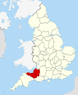
The county of Somerset is in South West England, bordered by the Bristol Channel and the counties of Bristol and Gloucestershire to the north, and Wiltshire to the east, Dorset to the south, and Devon to the west. The climate, influenced by its proximity to the Atlantic Ocean and the prevailing westerly winds, tends to be mild, damp and windy.

From December 2013 onwards the Somerset Levels suffered severe flooding as part of the wider 2013-2014 Atlantic winter storms in Europe and subsequent 2013–2014 United Kingdom winter floods. The Somerset Levels, or the Somerset Levels and Moors as they are less commonly but more correctly known, is a coastal plain and wetland area of central Somerset, in South West England, running south from the Mendip Hills to the Blackdown Hills.

The South Drain flows in a generally north-westerly direction from Actis Tunnel to Gold Corner, where it moves on to the Huntspill River, in Somerset, England. It flows through the Shapwick Heath Nature Reserve.
