
The Clackamas River is an approximately 83-mile (134 km) tributary of the Willamette River in northwestern Oregon, in the United States. Draining an area of about 940 square miles (2,435 km2), the Clackamas flows through mostly forested and rugged mountainous terrain in its upper reaches, and passes agricultural and urban areas in its lower third. The river rises in eastern Marion County, about 55 miles (89 km) east-southeast of Salem. The headwaters are on the slopes of Olallie Butte in the Mount Hood National Forest, about 10 miles (16 km) north of Mount Jefferson, at an elevation of 4,909 feet (1,496 m) in the Cascade Range. The Clackamas flows briefly north and then flows northwest through the mountains, passing through North Fork Reservoir and Estacada. It then emerges from the mountains southeast of Portland. It joins the Willamette near Oregon City and forms the boundary between Oregon City and Gladstone.

The John Day River is a tributary of the Columbia River, approximately 284 miles (457 km) long, in northeastern Oregon in the United States. It is known as the Mah-Hah River by the Cayuse people. Undammed along its entire length, the river is the fourth longest free-flowing river in the contiguous United States. There is extensive use of its waters for irrigation. Its course furnishes habitat for diverse species, including wild steelhead and Chinook salmon runs. However, the steelhead populations are under federal Endangered Species Act (ESA) protections, and the Chinook salmon have been proposed for such protection.

The Owyhee River is a tributary of the Snake River located in northern Nevada, southwestern Idaho and southeastern Oregon in the Western United States and its Pacific Northwest region. It is 280 miles (450 km) long. The river's drainage basin is 11,049 square miles (28,620 km2) in area, one of the largest subbasins of the Columbia River Basin with its major waterways of the Columbia River and Snake River. The mean annual discharge is 995 cubic feet per second (28.2 m3/s), with a maximum of 50,000 cu ft/s (1,400 m3/s) recorded in 1993 and a minimum of 42 cu ft/s (1.2 m3/s) in 1954.

The North Santiam River is a 92-mile (148 km) tributary of the Santiam River in western Oregon in the United States. It drains 766 square miles (1,980 km2) of the Cascade Range on the eastern side of the Willamette Valley east of Salem.
The Breitenbush River is a tributary of the North Santiam River in western Oregon in the United States. It drains a rugged, forested area of the Cascade Range east of Salem.
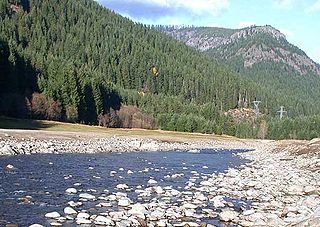
The Collawash River is a 12-mile (19 km) tributary of the Clackamas River in the U.S. state of Oregon. Formed by the confluence of Elk Lake Creek and the East Fork Collawash River in the Cascade Range, it flows generally north-northwest from source to mouth through the Mount Hood National Forest. The largest tributary of the upper Clackamas, it provides about a third of bigger river's low-flow volume. About 35 percent of its watershed of 150 square miles (390 km2) is protected as wilderness.

The Warm Springs River is a tributary of the Deschutes River in north-central Oregon in the United States. It flows generally southeast along the east side of the Cascade Range. The watershed is approximately between Mount Jefferson and Timothy Lake, and the northwestern and southwestern boundaries of the Warm Springs Indian Reservation coincide with the watershed. The headwaters are less than 1⁄4 mile (0.40 km) from the Wasco County–Clackamas County boundary. The river flows generally eastward, with occasional diagonals southeast or northeast. It joins the Deschutes River at river mile 83.7.
The North Fork Clackamas River is a tributary, about 11 miles (18 km) long, of the Clackamas River in the U.S. state of Oregon. Originating at nearly 4,000 feet (1,200 m) above sea level on the west side of the Cascade Range, it flows westward through Mount Hood National Forest. It joins the Clackamas at North Fork Reservoir, about 32 miles (51 km) from the larger river's confluence with the Willamette River. From source to mouth, the following tributaries enter the river: Dry Creek from the right bank, Boyer Creek from the left bank, then Whiskey, Bedford, Bee, and Fall creeks, all from the right.
The South Fork Rogue River is a 25-mile (40 km) tributary of the Rogue River in the U.S. state of Oregon. Rising in the Sky Lakes Wilderness in the Cascade Range, it flows generally northeast through the Rogue River – Siskiyou National Forest to meet the Rogue River downstream of Prospect and slightly upstream of Lost Creek Lake.

Sacajawea Peak is a peak in the Wallowa Mountains, in the U.S. state of Oregon. It is in the Eagle Cap Wilderness and the Wallowa–Whitman National Forest.

Little Butte Creek is a 17-mile-long (27 km) tributary of the Rogue River in the U.S. state of Oregon. Its drainage basin consists of approximately 354 square miles (917 km2) of Jackson County and another 19 square miles (49 km2) of Klamath County. Its two forks, the North Fork and the South Fork, both begin high in the Cascade Range near Mount McLoughlin and Brown Mountain. They both flow generally west until they meet near Lake Creek. The main stem continues west, flowing through the communities of Brownsboro, Eagle Point, and White City, before finally emptying into the Rogue River about 3 miles (5 km) southwest of Eagle Point.

The North Fork Bull Run River is a tributary, about 6 miles (10 km) long, of the Bull Run River in the U.S. state of Oregon. Part of the system that provides drinking water to the city of Portland, it flows generally south through a protected part of the Mount Hood National Forest in Multnomah County. It joins the Bull Run River at Bull Run Reservoir 1.

Big Butte Creek is a 12-mile-long (19 km) tributary of the Rogue River in the U.S. state of Oregon. It drains approximately 245 square miles (635 km2) of Jackson County. Its two forks, the North Fork and the South Fork, both begin high in the Cascade Range near Mount McLoughlin. Flowing predominantly west, they meet near the city of Butte Falls. The main stem flows generally northwest until it empties into the Rogue Falls was incorporated in 1911, and remains the only incorporated town within the watershed's boundaries.
The South Fork Coquille River is the longest tributary of the Coquille River in coastal Oregon in the United States. From its headwaters in the Southern Oregon Coast Range, the river flows northwest to join the North Fork Coquille River at Myrtle Point, forming the main stem Coquille. The South Fork is about 63 miles (101 km) long, and its watershed drains roughly 288 square miles (750 km2) of rural Coos County.

The South Fork Crooked River is a tributary, 76 miles (122 km) long, of the Crooked River in the U.S. state of Oregon. Starting southeast of Hampton in Deschutes County, the South Fork flows east from near Ram Lake (dry). It passes under U.S. Route 20 at Hampton, then continues east and north for about 6 miles (10 km) before entering Crook County. Shortly thereafter, east of Hampton Buttes, it receives Buck Creek from the right and then passes through Logan Reservoir. Flowing north, it receives Sand Hollow Creek from the left, then Twelvemile Creek from the right before crossing under Oregon Route 380. Just north of the highway, in southeastern Crook County, the river joins Beaver Creek to form the Crooked River 125 miles (201 km) from its confluence with the Deschutes River.
The South Fork Breitenbush River is a 10-mile (16 km) tributary of the Breitenbush River in the U.S. state of Oregon. The river flows generally northwest from Russell Lake in the Mount Jefferson Wilderness of the Cascade Range to near Breitenbush Hot Springs, where it merges with the North Fork Breitenbush River to form the main stem.

Breitenbush Lake is a 65-acre (26 ha) water body on a high plateau north of Mount Jefferson in the Cascade Range in the U.S. state of Oregon. The lake, fed by seepage and small creeks, is part of the North Fork Breitenbush River watershed. It is in Marion County near its border with Jefferson County and lies within the Mount Hood National Forest and the Warm Springs Indian Reservation at an elevation of about 5,500 feet (1,700 m).

The South Fork McKenzie River is a tributary, about 31 miles (50 km) long, of the McKenzie River in the U.S. state of Oregon. It begins at about 4,500 feet (1,400 m) above sea level near Mink Lake in the Three Sisters Wilderness of the Cascade Range. Flowing northwest within Lane County, it meets the McKenzie River about 60 miles (97 km) from the larger river's confluence with the Willamette River.
The South Fork Salmon River is a tributary of the Salmon River in Clackamas County in the U.S. state of Oregon. Arising near Plaza Lake, it flows generally northeast along the east side of Salmon Mountain to meet the Salmon 11 miles (18 km) upstream of the larger stream's confluence with the Sandy River at Brightwood.
The Middle Fork Coquille River is a tributary, about 40 miles (64 km) long, of the South Fork Coquille River in the U.S. state of Oregon. It begins near Camas Mountain in Douglas County in the Southern Oregon Coast Range. It flows generally south, bypassing the community of Camas Valley while passing through the valley of the same name, then curves west and north to Remote in Coos County. The Middle Fork then flows generally west, passes by the small community of Bridge, and meets the South Fork near Myrtle Point. The confluence with the South Fork is 41 miles (66 km) by water to where the main stem of the Coquille River enters the Pacific Ocean at Bandon.

