South Fork Breitenbush River

Last updated
South Fork Breitenbush River
USA Oregon location map.svg
Red pog.svg
Location of the mouth of the South Fork Breitenbush River in Oregon
Location
Country United States
State Oregon
County Marion
Physical characteristics
Source Russell Lake
 - location Mount Jefferson Wilderness, Willamette National Forest, Cascade Range
 - coordinates 44°42′53″N121°47′58″W / 44.71472°N 121.79944°W / 44.71472; -121.79944 [1]
 - elevation5,886 ft (1,794 m) [2]
Mouth Breitenbush River
 - location Breitenbush Hot Springs
 - coordinates 44°46′47″N121°57′53″W / 44.77972°N 121.96472°W / 44.77972; -121.96472 Coordinates: 44°46′47″N121°57′53″W / 44.77972°N 121.96472°W / 44.77972; -121.96472 [1]
 - elevation2,277 ft (694 m) [1]
Length10 mi (16 km) [3]

The South Fork Breitenbush River is a 10-mile (16 km) tributary of the Breitenbush River in the U.S. state of Oregon. [1] The river flows generally northwest from Russell Lake in the Mount Jefferson Wilderness of the Cascade Range to near Breitenbush Hot Springs, where it merges with the North Fork Breitenbush River to form the main stem. [4]

Breitenbush River river in the United States of America

The Breitenbush River is a tributary of the North Santiam River in western Oregon in the United States. It drains a rugged, forested area of the Cascade Range east of Salem.

U.S. state constituent political entity sharing sovereignty as the United States of America

In the United States, a state is a constituent political entity, of which there are currently 50. Bound together in a political union, each state holds governmental jurisdiction over a separate and defined geographic territory and shares its sovereignty with the federal government. Due to this shared sovereignty, Americans are citizens both of the federal republic and of the state in which they reside. State citizenship and residency are flexible, and no government approval is required to move between states, except for persons restricted by certain types of court orders. Four states use the term commonwealth rather than state in their full official names.

Oregon State of the United States of America

Oregon is a state in the Pacific Northwest region on the West Coast of the United States. The Columbia River delineates much of Oregon's northern boundary with Washington, while the Snake River delineates much of its eastern boundary with Idaho. The parallel 42° north delineates the southern boundary with California and Nevada. Oregon is one of only three states of the contiguous United States to have a coastline on the Pacific Ocean.

Contents

The South Fork receives Lake Creek and Roaring Creek, both from the right, as it descends through the wilderness and the Willamette National Forest. [4] From the confluence of its forks, the main stem Breitenbush River flows about 11 miles (18 km) further to its confluence with the North Santiam River in Detroit Lake. [5]

Willamette National Forest United States national forest in Oregon

The Willamette National Forest is a National Forest located in the central portion of the Cascade Range of the U.S. state of Oregon. It comprises 1,678,031 acres (6,790.75 km2), making it one of the largest national forests. Over 380,000 acres are designated wilderness which include seven major mountain peaks. There are also several National Wild and Scenic Rivers within the forest. The forest is named for the Willamette River, which has its headwaters in the forest. The forest headquarters are located in the city of Springfield. There are local ranger district offices in McKenzie Bridge, Detroit, Sweet Home, and Westfir.

North Santiam River river in the United States of America

The North Santiam River is a 92-mile (148 km) tributary of the Santiam River in western Oregon in the United States. It drains 766 square miles (1,980 km2) of the Cascade Range on the eastern side of the Willamette Valley east of Salem.

Detroit Lake reservoir in Oregon, United States

Detroit Lake is a reservoir impounded by the Detroit Dam on the North Santiam River 46 miles (74 km) southeast of Salem, Oregon, United States. The lake is adjacent to Oregon Route 22 near the city of Detroit. This mesotrophic lake stores water for use by the city of Salem and other nearby communities.

Recreation

The Pacific Crest Trail crosses the South Fork near Russell Lake. [4] South Breitenbush Trail, which parallels the river for about 6 miles (10 km) in its upper reaches, offers opportunities for hiking and backpacking at elevations ranging from 3,050 to 5,850 feet (930 to 1,780 m) above sea level. [6]

Pacific Crest Trail long-distance hiking and equestrian trail in the USA

The Pacific Crest Trail, officially designated as the Pacific Crest National Scenic Trail (PCT) is a long-distance hiking and equestrian trail closely aligned with the highest portion of the Sierra Nevada and Cascade mountain ranges, which lie 100 to 150 miles east of the U.S. Pacific coast. The trail's southern terminus is on the U.S. border with Mexico, just south of Campo, California, and its northern terminus on the Canada–US border on the edge of Manning Park in British Columbia; its corridor through the U.S. is in the states of California, Oregon, and Washington.

South Breitenbush Gorge Trail, along the river closer to its confluence with the main stem, passes through older Douglas-fir and western hemlock forest. This trail, ranging in elevation from 2,300 to 2,800 feet (700 to 850 m), is 2.5 miles (4.0 km) long. A side trail leads to a narrow canyon, about 300 feet (91 m) long, where the river flows between walls of basalt. [7]

Main stem final large channel of a riverine system

In hydrology, a main stem is "the primary downstream segment of a river, as contrasted to its tributaries". Water enters the main stem from the river's drainage basin, the land area through which the main stem and its tributaries flow. A drainage basin may also be referred to as a watershed or catchment.

<i>Tsuga heterophylla</i> species of plant

Tsuga heterophylla, the western hemlock or western hemlock-spruce, is a species of hemlock native to the west coast of North America, with its northwestern limit on the Kenai Peninsula, Alaska, and its southeastern limit in northern Sonoma County, California.

Basalt A magnesium- and iron-rich extrusive igneous rock

Basalt is a mafic extrusive igneous rock formed from the rapid cooling of magnesium-rich and iron-rich lava exposed at or very near the surface of a terrestrial planet or a moon. More than 90% of all volcanic rock on Earth is basalt. Basalt lava has a low viscosity, due to its low silica content, resulting in rapid lava flows that can spread over great areas before cooling and solidification. Flood basalt describes the formation in a series of lava basalt flows.

See also

Related Research Articles

Salmon River (Idaho) river in Idaho in the Northwestern United States

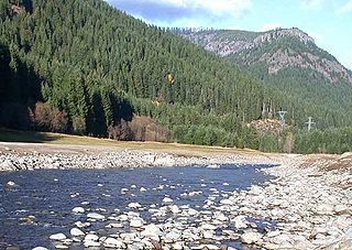
The Salmon River is located in Idaho in the northwestern United States. The Salmon is also known as "The River of No Return". It flows for 425 miles (684 km) through central Idaho, draining a rugged, thinly populated watershed of 14,000 square miles (36,260 km2) and dropping more than 7,000 feet (2,130 m) between its headwaters, near Galena Summit above the Sawtooth Valley in the Sawtooth National Recreation Area, and its confluence with the Snake River. Measured at White Bird, its average discharge is 11,060 cubic feet (310 m3) per second. It is one of the largest rivers in the continental United States without a single dam on its mainstem.

McKenzie River (Oregon) tributary of the Willamette River in Oregon

The McKenzie River is a 90-mile (145 km) tributary of the Willamette River in western Oregon in the United States. It drains part of the Cascade Range east of Eugene and flows westward into the southernmost end of the Willamette Valley. It is named for Donald McKenzie, a Scottish Canadian fur trader who explored parts of the Pacific Northwest for the Pacific Fur Company in the early 19th century. As of the 21st century, six large dams have been built on the McKenzie and its tributaries.

Elk River (Oregon) river in southwestern Oregon in the United States

The Elk River is in southwestern Oregon in the United States. About 29 miles (47 km) long, the river drains a remote 92-square-mile (240 km2) area of the Coast Range into the Pacific Ocean.

Hells Canyon Wilderness (Oregon and Idaho)

The Hells Canyon Wilderness is a wilderness area in the western United States, in Idaho and Oregon. Created 44 years ago in 1975, the Wilderness is managed by both the U.S. Bureau of Land Management and the U.S. Forest Service and contains some of the most spectacular sections of the Snake River as it winds its way through Hells Canyon, North America's deepest river gorge and one of the deepest gorges on Earth. The Oregon Wilderness Act of 1984 added additional acreage and currently the area protects a total area of 217,927 acres (88,192 ha). It lies entirely within the Hells Canyon National Recreation Area except for a small 946-acre (383 ha) plot in southeastern Wallowa County, Oregon which is administered by the Bureau of Land Management. The area that is administered by the Forest Service consists of portions of the Wallowa, Nez Perce, Payette, and Whitman National Forests.

Collawash River river in the United States of America

The Collawash River is a 12-mile (19 km) tributary of the Clackamas River in the U.S. state of Oregon. Formed by the confluence of Elk Lake Creek and the East Fork Collawash River in the Cascade Range, it flows generally north-northwest from source to mouth through the Mount Hood National Forest. The largest tributary of the upper Clackamas, it provides about a third of bigger river's low-flow volume. About 35 percent of its watershed of 150 square miles (390 km2) is protected as wilderness.

Salmon River (Clackamas County, Oregon) river in Oregons Cascade Range

The Salmon River is a 33.5-mile (53.9 km) river in the Cascade Range in the U.S. state of Oregon that drains part of southwestern Mount Hood. The entire length of the river is a protected National Wild and Scenic River. Several portions are in protected wilderness. It is affluent to the Sandy River, a tributary of the Columbia River.

Oak Grove Fork Clackamas River river in the United States of America

Oak Grove Fork Clackamas River is a 21-mile (34 km) tributary of the Clackamas River in the U.S. state of Oregon. From its headwaters in the Warm Springs Indian Reservation near Abbot Pass in the Cascade Range, the river flows generally west through Mount Hood National Forest in Clackamas County to the unincorporated community of Ripplebrook. Here it enters the main stem of the Clackamas River. Oak Grove Fork feeds Timothy Lake and Lake Harriet, two artificial impoundments built along its course to control water flows to hydroelectric plants.

Wenaha River river in the United States of America

The Wenaha River is a tributary of the Grande Ronde River, about 22 miles (35 km) long, in the U.S. state of Oregon. The river begins at the confluence of its north and south forks in the Blue Mountains and flows east through the Wenaha–Tucannon Wilderness to meet the larger river at the small settlement of Troy. A designated Wild and Scenic River for its entire length, the stream flows wholly within Wallowa County.

South Fork Rogue River tributary of the Rogue River in Oregon

The South Fork Rogue River is a 25-mile (40 km) tributary of the Rogue River in the U.S. state of Oregon. Rising in the Sky Lakes Wilderness in the Cascade Range, it flows generally northeast through the Rogue River – Siskiyou National Forest to meet the Rogue River downstream of Prospect and slightly upstream of Lost Creek Lake.

Muddy Fork (Oregon) river in the United States of America

Muddy Fork is a tributary, about 6 miles (10 km) long, of the Sandy River in the U.S. state of Oregon. Arising at the base of Sandy Glacier on the west slope of Mount Hood, it flows west through the Mount Hood Wilderness in the Mount Hood National Forest. It joins the Sandy River in Old Maid Flat, about 5 miles (8 km) northeast of Rhododendron. The stream offers limited fishing for coastal cutthroat trout.

South Fork Coquille River river in the United States of America

The South Fork Coquille River is the longest tributary of the Coquille River in coastal Oregon in the United States. From its headwaters in the Southern Oregon Coast Range, the river flows northwest to join the North Fork Coquille River at Myrtle Point, forming the main stem Coquille. The South Fork is about 63 miles (101 km) long, and its watershed drains roughly 288 square miles (750 km2) of rural Coos County.

North Fork Payette River river in the United States of America

The North Fork Payette River is a river in western Idaho in the United States. It stretches over 113 miles (182 km) from north to south, flowing from the Salmon River Mountains to near Banks, where it joins with the South Fork Payette River to form the Payette River, a tributary of the Snake River. Its watershed comprises more than 900 square miles (2,300 km2) of forested mountains and sprawling lakes and wetlands.

North Fork Breitenbush River river in the United States of America

The North Fork Breitenbush River is a tributary of the Breitenbush River in the U.S. state of Oregon. It begins at Papoose Lakes near Breitenbush Lake in the Cascade Range north of Mount Jefferson and flows generally northwest and west through the Mount Hood National Forest, Olallie Scenic Area, Mount Jefferson Wilderness, and Willamette National Forest. It merges with the South Fork Breitenbush River to form the Breitenbush River main stem slightly upstream of Breitenbush Hot Springs.

South Fork McKenzie River tributary of the McKenzie River in Oregon

The South Fork McKenzie River is a tributary, about 31 miles (50 km) long, of the McKenzie River in the U.S. state of Oregon. It begins at about 4,500 feet (1,400 m) above sea level near Mink Lake in the Three Sisters Wilderness of the Cascade Range. Flowing northwest within Lane County, it meets the McKenzie River about 60 miles (97 km) from the larger river's confluence with the Willamette River.

South Fork Burnt River river in the United States of America

The South Fork Burnt River is a tributary of the Burnt River in Baker County in the U.S. state of Oregon. Its headwaters lie in the Monument Rock Wilderness and the Wallowa–Whitman National Forest of the Blue Mountains. It flows generally northeast for about to meet the main stem at Unity Reservoir, north of Unity. The river, about 12 miles (19 km) long, crosses under U.S. Route 26 about 3 miles (5 km) northwest of Unity.

North Fork Umatilla River river in the United States of America

The North Fork Umatilla River is a tributary of the Umatilla River in Union and Umatilla counties in the U.S. state of Oregon. Its headwaters lie in the Umatilla National Forest in the Blue Mountains of northeastern Oregon. It flows generally northwest to meet the South Fork Umatilla River near Graves Butte. Together the two forks form the main stem Umatilla.

Middle Fork Rogue River river in the United States of America

The Middle Fork Rogue River is a tributary of the South Fork Rogue River in the U.S. state of Oregon. It begins in Klamath County in the Sky Lakes Wilderness of the Cascade Range and flows generally northwest through the Rogue River – Siskiyou National Forest to meet the South Fork south of Prospect. The Middle Fork enters the South Fork about 4 miles (6 km) from the South Fork's confluence with the Rogue River.

South Fork Salmon River (Oregon)

The South Fork Salmon River is a tributary of the Salmon River in Clackamas County in the U.S. state of Oregon. Arising near Plaza Lake, it flows generally northeast along the east side of Salmon Mountain to meet the Salmon 11 miles (18 km) upstream of the larger stream's confluence with the Sandy River at Brightwood.

South Fork Wenaha River river in the United States of America

The South Fork Wenaha River is a tributary of the Wenaha River in the U.S. state of Oregon. The river begins in the Blue Mountains south of Bone Spring in Wallowa County near its border with Union County. From there it flows generally northeast through the Wenaha–Tucannon Wilderness of the Umatilla National Forest to meet the North Fork Wenaha River. The combined forks form the main stem Wenaha, a tributary of the Grande Ronde River.

References

  1. 1 2 3 4 "South Fork Breitenbush River". Geographic Names Information System (GNIS). United States Geological Survey. November 28, 1980. Retrieved May 3, 2012.
  2. Source elevation derived from Google Earth search using GNIS source coordinates.
  3. "Conservation and Outdoor Recreation: Oregon Segments". National Park Service. February 27, 2009. Retrieved May 3, 2012.
  4. 1 2 3 Oregon Atlas & Gazetteer. Freeport, Maine: DeLorme Mapping. 1991. p. 56. ISBN   0-89933-235-8.
  5. United States Geological Survey (USGS). "United States Geological Survey Topographic Map". TopoQuest. Retrieved May 4, 2012. The map quadrangles include river mile (RM) markers along the Breitenbush River.
  6. "South Breitenbush Trail #3375". U.S. Forest Service. Retrieved May 4, 2012.
  7. "South Breitenbush Gorge Trail #3366". U.S. Forest Service. Retrieved May 4, 2012.