Related Research Articles

In geology, a fault is a planar fracture or discontinuity in a volume of rock across which there has been significant displacement as a result of rock-mass movements. Large faults within Earth's crust result from the action of plate tectonic forces, with the largest forming the boundaries between the plates, such as the megathrust faults of subduction zones or transform faults. Energy release associated with rapid movement on active faults is the cause of most earthquakes. Faults may also displace slowly, by aseismic creep.

The Caribbean Plate is a mostly oceanic tectonic plate underlying Central America and the Caribbean Sea off the northern coast of South America.
Strike-slip tectonics or wrench tectonics is a type of tectonics that is dominated by lateral (horizontal) movements within the Earth's crust. Where a zone of strike-slip tectonics forms the boundary between two tectonic plates, this is known as a transform or conservative plate boundary. Areas of strike-slip tectonics are characterised by particular deformation styles including: stepovers, Riedel shears, flower structures and strike-slip duplexes. Where the displacement along a zone of strike-slip deviates from parallelism with the zone itself, the style becomes either transpressional or transtensional depending on the sense of deviation. Strike-slip tectonics is characteristic of several geological environments, including oceanic and continental transform faults, zones of oblique collision and the deforming foreland of zones of continental collision.

The 2002 Denali earthquake occurred at 22:12:41 UTC November 3 with an epicenter 66 km ESE of Denali National Park, Alaska, United States. This 7.9 Mw earthquake was the largest recorded in the United States in 37 years. The shock was the strongest ever recorded in the interior of Alaska. Due to the remote location, there were no fatalities and only one injury.
The 1995 Antofagasta earthquake occurred on July 30 at 05:11 UTC with a moment magnitude of 8.0 and a maximum Mercalli intensity of VII. The Antofagasta Region in Chile was affected by a moderate tsunami, with three people killed, 58 or 59 injured, and around 600 homeless. Total damage from the earthquake and tsunami amounted to $1.791 million.

The 1911 Kebin earthquake, or Chon-Kemin earthquake, struck Russian Turkestan on 3 January. Registering at a moment magnitude of 8.0, it killed 452 people, destroyed more than 770 buildings in Almaty, Kazakhstan, and resulted in 125 miles (201 km) of surface faulting in the valleys of Chon-Kemin, Chilik and Chon-Aksu.

The Enriquillo–Plantain Garden fault zone is a system of active coaxial left lateral-moving strike slip faults which runs along the southern side of the island of Hispaniola, where Haiti and the Dominican Republic are located. The EPGFZ is named for Lake Enriquillo in the Dominican Republic where the fault zone emerges, and extends across the southern portion of Hispaniola through the Caribbean to the region of the Plantain Garden River in Jamaica.
The Gonâve Microplate forms part of the boundary between the North American Plate and the Caribbean Plate. It is bounded to the west by the Mid-Cayman Rise spreading center, to the north by the Septentrional-Oriente fault zone and to the south by the Walton fault zone and the Enriquillo–Plantain Garden fault zone. The existence of this microplate was first proposed in 1991. This has been confirmed by GPS measurements, which show that the overall displacement between the two main plates is split almost equally between the transform fault zones that bound the Gonâve microplate. The microplate is expected to eventually become accreted to the North American Plate.

The Marlborough fault system is a set of four large dextral strike-slip faults and other related structures in the northern part of South Island, New Zealand, which transfer displacement between the mainly transform plate boundary of the Alpine fault and the mainly destructive boundary of the Kermadec Trench, and together form the boundary between the Australian and Pacific Plates.

The Altyn Tagh Fault (ATF) is a 2,000 km long, active, sinistral strike-slip fault that forms the northwestern boundary of the Tibetan Plateau with the Tarim Basin. It is one of the major sinistral strike-slip structures that together help to accommodate the eastward motion of this zone of thickened crust, relative to the Eurasian Plate. A total displacement of about ~475 km has been estimated for this fault zone since the middle Oligocene, although the amount of displacement, age of initiation and slip rate are disputed.
The 1842 Cap-Haïtien earthquake occurred at 17:00 local time on 7 May. It had an estimated magnitude of 8.1 on the Ms scale and triggered a destructive tsunami. It badly affected the northern coast of Haiti and part of what is now the Dominican Republic. Port-de-Paix suffered the greatest damage from both earthquake and tsunami. Approximately 5,000 people were killed by the effects of the earthquake shaking and another 300 by the tsunami.
The Zhongwei-Tongxin fault or Tianjingshan fault is an arcuate sinistral (left-lateral) strike-slip zone, forming one of the major structures on the northeastern margin of Tibetan plateau. Six paleoearthquake events in the past 14,000 years have been recorded along the Zhongwei-Tongxin fault zone. Among the earthquakes recorded are the 1622 North Guyuan earthquake, which had a magnitude of 7.0 and mid-seismogenic depth of about 15 kilometres (9.3 mi), the 1709 Zhongwei earthquake, which had a magnitude of 7.5.
The Palu-Koro Fault or Palu-Koro Fault System is a major active NNW-SSE trending left-lateral strike-slip fault zone on the island of Sulawesi in Indonesia. It caused the 2018 Sulawesi earthquake and tsunami.
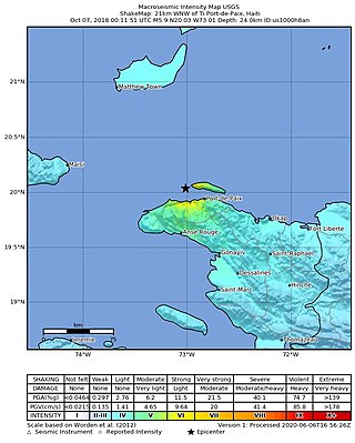
On October 6, 2018, at approximately 8:11 p.m, a magnitude 5.9 earthquake struck 19 kilometers northwest of Port-de-Paix, Haiti. The earthquake damaged structures and killed 18 people.
The geology of the Dominican Republic is part of the broader geology of Hispaniola with rocks formed from multiple island arcs, colliding with North America.
On January 1, 1996, at 4:05 p.m. Central Indonesia Time, an earthquake with an epicenter in the Makassar Strait struck north of Minahasa on the island of Sulawesi, Indonesia. The earthquake measured 7.9 on the moment magnitude scale and was centered off Tolitoli Regency in Central Sulawesi, or 25 km from the Tonggolobibi village. A tsunami of 2–4 m (6.6–13.1 ft) was triggered by this earthquake as a result. At least 350 buildings were badly damaged, nine people died and 63 people were injured.
The western coast of West Sulawesi was struck by a major earthquake on 23 February 1969 at 00:36 UTC. It had a magnitude of 7.0 Mw and a maximum felt intensity of VIII on the Modified Mercalli intensity scale. It triggered a major tsunami that caused significant damage along the coast of the Makassar Strait. At least 64 people were killed, with possibly a further 600 deaths caused by the tsunami.

The Ordos Block is a crustal block, that forms part of the larger North China Block (NCB). It is surrounded by active fault systems and has been a distinct block since at least the Mesozoic. It is bordered to the west by the Alxa Block, the westernmost part of the NCB, to the south by the Qinling orogenic belt, to the north by the Yanshan-Yinshan orogenic belt, part of the Central Asian Orogenic Belt and to the east by the Taihangshan mountain range, which forms part of the Trans-North China Orogen. The block is currently stable and large earthquakes are restricted to the bordering fault zones. It has been suggested that the block is currently undergoing anti-clockwise rotation with respect to the Eurasian Plate, as a result of the ongoing eastward spreading of the Tibetan Plateau, although this view has been challenged.
The 1923 Renda earthquake occurred on March 24 at 20:40 local time between the counties of Daofu and Luhuo in Sichuan, China. The estimated Ms 7.3 earthquake was assigned a maximum modified Mercalli intensity scale rating of X (Extreme). Severe damage occurred in Sichuan, killing an estimated 4,800 people.
References
- ↑ Calais E.; Mazabraud Y.; de Lépinay B.M.; Mann P.; Mattioli G.; Jansma P. (2002). "Strain partitioning and fault slip rates in the northeastern Caribbean from GPS measurements". Geophysical Research Letters. 29 (18): 3-1–3-4. doi: 10.1029/2002GL015397 .
| | This article about structural geology is a stub. You can help Wikipedia by expanding it. |