
Interstate 610 (I-610) is an auxiliary Interstate Highway that forms a 37.972-mile-long (61.110 km) loop around the inner city sector of the city of Houston, Texas. I-610, colloquially known as The Loop, Loop 610, The Inner Loop, or just 610, traditionally marks the border between the inner city of Houston and its surrounding areas. It is the innermost of the three Houston beltways, the other two being Beltway 8 and State Highway 99, of which various segments are under construction or planning. In Houston, the area inside I-610 is the urban core. Jeff Balke of the Houston Press wrote that the freeway "is as much a social and philosophical divide as a physical one". Mike Snyder in the Houston Chronicle wrote that, as someone from inside I-610, he historically felt "kind of special" due to being close to "the city's historical core and its major business, educational and cultural institutions".

Bongaigaon district (Prpn:ˈbɒŋgaɪˌgãʊ) is an administrative district in the state of Assam in northeastern India. The district headquarters are located at Bongaigaon. The district occupies an area of 1,093 km2.
Campo is a town on the Atlantic Ocean coast of southern Cameroon, where it is the main border town for travel to Equatorial Guinea. The town is just north of the mouth of the Ntem River, that is to say the right bank of that river.
Abhayapuri is a town in Bongaigaon district and 21 km away from Bongaigaon city. It is the headquarters of North Salmara sub-division. It is surrounded by natural forests and hills, and is located on the National Highway 31, about 200 km west of Guwahati. Its nearest airport is at Azara, Guwahati and at Rupsi and nearest railway station is Abhayapuri Railway Station.
The Lytton First Nation, a First Nations band government, has its headquarters at Lytton in the Fraser Canyon region of the Canadian province of British Columbia. While it is the largest of all Nlaka'pamux bands, unlike all other governments of the Nlaka'pamux (Thompson) people, it is not a member of any of the three Nlaka'pamux tribal councils, which are the Nicola Tribal Association, the Fraser Canyon Indian Administration and the Nlaka'pamux Nation Tribal Council.

Abhayapuri North Assembly constituency is one of the 126 constituencies of the Legislative Assembly of Assam state in northeastern India.

Dhubri Lok Sabha constituency is one of the 14 Lok Sabha constituencies in Assam state in north-eastern India. Dhubri consists of 10 assembly segments of Lower Assam, covering all of South Salmara-Mankachar District and Dhubri districts and part of Goalpara district. This seat is a AIUDF stronghold.
Anaka is a town in the Northern Region of Uganda. It is the site of the Nwoya District headquarters.
Seeta, sometimes wrongly spelled as Seta, is a township in Uganda.
Manikpur is a small town and a Block and a Sub division in Bongaigaon district in the Indian state of Assam. Manikpur is 33 km far from its district main city Bongaigaon. It is 155 km far from its state capital Dispur. The majority of the people in Manikpur belong to the Koch community of Austro-Mongoloid ethnicity. With the passage of time, Assamese caste Hindus and Muslims have started settling in Manikpur. Politically, the area is part of Abhayapuri North.

Delta Farms is an area in Lafourche Parish, just north of Larose. It was originally a swamp area that was surrounded by levees to create a farmland.

Unakoti is an administrative district in the state of Tripura in northeastern India. It is the least populated district of Tripura, with fourth highest literacy rate. The district has a total of four sub divisions and two blocks. The district was created in 2012, by bifurcating the North Tripura district with its headquarter in Kailashahar.
Abhayapuri College, situated at Abhayapuri town, is one of the oldest institutions of higher education in lower Assam. The college was established on 13 August 1955. Currently the college has two streams, Science and Arts, and is affiliated to the Gauhati University.
National Highway 17 is a National Highway in India running from Sevoke in West Bengal to Guwahati in Assam.
National Highway 117 is a national highway in India. This route was earlier part of old national highway 31. It is a secondary route of National Highway 17. NH-117 runs through the state of Assam in India.

South Salmara-Mankachar is an administrative district in the state of Assam in India. The district headquarter is located at Hatsingimari village which is situated at about 245 km from Guwahati. It was earlier a sub-division of the Dhubri District.
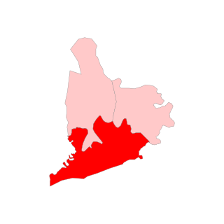
Abhayapuri South Assembly constituency is one of the 126 constituencies of the Assam Legislative Assembly, in Assam, northeastern India.

Pradip Sarkar is an Indian politician serving as the member of the Assam Legislative Assembly from Abhayapuri South since 2021, defeating AGP's Purnendu Banikya. He is a member of the Indian National Congress. His father, Chandan Sarkar was also MLA and minister in the Government of Assam and his mother, Swapna Rani Sarkar was chairman of Abhayapuri Town Committee.
Chandan Kumar Sarkar was an Indian politician from the state of Assam. He served as the Minister of Irrigation and Soil Conservation in the Third Tarun Gogoi Ministry from 2015 to 2016. He was a member of the Assam Legislative Assembly from Abhayapuri South constituency from 1991 to 1996, 2001 to 2006 and again from 2011 to 2016. His son Pradip Sarkar was the current MLA from Abhayapuri South Assembly constituency.

