North Umpqua Trail

Last updated
North Umpqua Trail

Dreadandterrorwater.jpg

View of a small waterfall on the Dread and Terror Section of the North Umpqua Trail
Length 79 mi (127 km)
Location Douglas County, Oregon, United States
Trailheads Swiftwater
Tioga
Wright Creek
Mott
Panther
Calf
Marsters
Soda Springs
Toketee Lake
Hot Springs
White Mule
Kelsay Valley
Digit Point
Use Hiking
Horse riding
Mountain biking
Elevation
Elevation change 4,200 ft (1,300 m)
Highest point Maidu Lake, 6,000 ft (1,800 m)
Lowest point Swiftwater Trailhead
Hiking details
Trail difficulty Easy to difficult
Months Lower Sections Open Year Round
Upper Sections Late April to Late September
Sights North Umpqua River
Cascade Range
Hazards Severe weather
Dehydration
Wildlife
Poison oak

The North Umpqua Trail is a multi-use trail open for hiking, mountain biking and horse-back riding that follows the North Umpqua River in Southern Oregon, United States. The trail is about 79 miles (127 km) long. It is broken up into 12 segments, ranging from 3.5 to 13 miles (21 km) in length. The trail ranges in elevation from 800 feet (240 m) to about 6,000 feet (1,800 m). [1]

North Umpqua River tributary of the Umpqua River in the USA

The North Umpqua River is a tributary of the Umpqua River, about 106 miles (171 km) long, in southwestern Oregon in the United States. It drains a scenic and rugged area of the Cascade Range southeast of Eugene, flowing through steep canyons and surrounded by large Douglas-fir forests. Renowned for its emerald green waters, it is considered one of the best fly fishing streams in the Pacific Northwest for anadromous fish.

Southern Oregon

Southern Oregon is a region of the U.S. state of Oregon south of Lane County and generally west of the Cascade Range, excluding the southern Oregon Coast. Counties include Douglas, Jackson, Klamath, and Josephine. It includes the Southern Oregon American Viticultural Area, which consists of the Umpqua and Rogue River drainages. As of 2015, the population in the four counties is about 471,000, and in the greater, seven-county definition is about 564,000.

United States Federal republic in North America

The United States of America (USA), commonly known as the United States or America, is a country comprising 50 states, a federal district, five major self-governing territories, and various possessions. At 3.8 million square miles, the United States is the world's third or fourth largest country by total area and is slightly smaller than the entire continent of Europe's 3.9 million square miles. With a population of over 327 million people, the U.S. is the third most populous country. The capital is Washington, D.C., and the largest city by population is New York City. Forty-eight states and the capital's federal district are contiguous in North America between Canada and Mexico. The State of Alaska is in the northwest corner of North America, bordered by Canada to the east and across the Bering Strait from Russia to the west. The State of Hawaii is an archipelago in the mid-Pacific Ocean. The U.S. territories are scattered about the Pacific Ocean and the Caribbean Sea, stretching across nine official time zones. The extremely diverse geography, climate, and wildlife of the United States make it one of the world's 17 megadiverse countries.

Contents

Route

The North Umpqua Trail is a designated National Recreation Trail and follows the North Umpqua River as it winds west out of the Cascades and towards the city of Roseburg, Oregon. The trail is inside the Roseburg District BLM and Umpqua National Forest lands and closely follows the river for most of its length. It has been designated by the International Mountain Biking Association as an 'Epic Ride', an honor bestowed on only a handful of trails around the world.

Cascade Range mountain range in western North America

The Cascade Range or Cascades is a major mountain range of western North America, extending from southern British Columbia through Washington and Oregon to Northern California. It includes both non-volcanic mountains, such as the North Cascades, and the notable volcanoes known as the High Cascades. The small part of the range in British Columbia is referred to as the Canadian Cascades or, locally, as the Cascade Mountains. The latter term is also sometimes used by Washington residents to refer to the Washington section of the Cascades in addition to North Cascades, the more usual U.S. term, as in North Cascades National Park. The highest peak in the range is Mount Rainier in Washington at 14,411 feet (4,392 m).

Roseburg, Oregon City in Oregon, United States

Roseburg is a city in the U.S. state of Oregon. It is in the Umpqua River Valley in southern Oregon and is the county seat and most populous city of Douglas County. Founded in 1851, the population was 21,181 at the 2010 census, making it the principal city of the Roseburg, Oregon Micropolitan Statistical Area. The community developed along both sides of the South Umpqua River and is traversed by Interstate 5. Traditionally a lumber industry town, Roseburg is the home of Roseburg Forest Products.

point coord notes
Swiftwater County Park 43°19′40″N123°00′13″W / 43.32764°N 123.00353°W / 43.32764; -123.00353 (western end) Coordinates: 43°19′40″N123°00′13″W / 43.32764°N 123.00353°W / 43.32764; -123.00353 (western end) western end, near Deadline Falls
Fern Creek Falls 43°19′09″N122°59′21″W / 43.31909°N 122.98924°W / 43.31909; -122.98924 (Fern Creek Falls) bridge creek crossing with view of falls and North Umpqua
Bob Butte flank 43°17′52″N122°57′17″W / 43.29776°N 122.95461°W / 43.29776; -122.95461 (Bob Butte flank) highest point on Bob Butte, elevation approx. 1700 ft of 2300+
east end of Tioga segment 43°19′31″N122°47′41″W / 43.32536°N 122.79462°W / 43.32536; -122.79462 (east end Tioga segment) joins Mott segment
Maidu Lake 43°15′18″N121°59′59″W / 43.255°N 121.99972°W / 43.255; -121.99972 (eastern end) eastern end, near Pacific Crest Trail

Related Research Articles

Douglas County, Oregon County in the United States

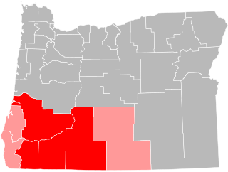
Douglas County is a county in the U.S. state of Oregon. As of the 2010 census, the population was 107,667. The county seat is Roseburg. It is named after Stephen A. Douglas, an American politician who supported Oregon statehood.

Umpqua River river in the United States of America

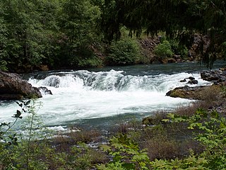
The Umpqua River on the Pacific coast of Oregon in the United States is approximately 111 miles (179 km) long. One of the principal rivers of the Oregon Coast and known for bass and shad, the river drains an expansive network of valleys in the mountains west of the Cascade Range and south of the Willamette Valley, from which it is separated by the Calapooya Mountains. From its source northeast of Roseburg, the Umpqua flows northwest through the Oregon Coast Range and empties into the Pacific at Winchester Bay. The river and its tributaries flow entirely within Douglas County, which encompasses most of the watershed of the river from the Cascades to the coast. The "Hundred Valleys of the Umpqua" form the heart of the timber industry of southern Oregon, generally centered on Roseburg.

Maidu Lake lake of the United States of America

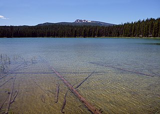
Maidu Lake is a small natural freshwater lake in the Cascade Range in eastern Douglas County in the U.S. state of Oregon. It is in the Mount Thielsen Wilderness of the Umpqua National Forest, about 15 miles (24 km) west of the community of Chemult.

South Umpqua River river in the United States of America

The South Umpqua River is a tributary of the Umpqua River, approximately 115 miles (185 km) long, in southwestern Oregon in the United States. It drains part of the Cascade Range east of Roseburg. The river passes through a remote canyon in its upper reaches then emerges in the populated South Umpqua Valley east of Canyonville.

Little River (North Umpqua River tributary) tributary of the North Umpqua River in Oregon, United States of America

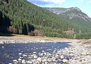
The Little River is a tributary of the North Umpqua River, about 30 miles (48 km) long, in southwestern Oregon in the United States. It drains part of the western side of the Cascade Range east of Roseburg, between the North and South Umpqua.

Calapooya Mountains mountain range

The Calapooya Mountains are a mountain range in Lane and Douglas counties of southwestern Oregon in the United States. The range runs for approximately 60 miles (97 km) west from the Cascade Range between Eugene on the north and Roseburg on the south.

Willamette National Forest United States national forest in Oregon

The Willamette National Forest is a National Forest located in the central portion of the Cascade Range of the U.S. state of Oregon. It comprises 1,678,031 acres (6,790.75 km2), making it one of the largest national forests. Over 380,000 acres are designated wilderness which include seven major mountain peaks. There are also several National Wild and Scenic Rivers within the forest. The forest is named for the Willamette River, which has its headwaters in the forest. The forest headquarters are located in the city of Springfield. There are local ranger district offices in McKenzie Bridge, Detroit, Sweet Home, and Westfir.

Siskiyou Trail

The Siskiyou Trail stretched from California's Central Valley to Oregon's Willamette Valley; modern-day Interstate 5 follows this pioneer path. Originally based on existing Native American foot trails winding their way through river valleys, the Siskiyou Trail provided the shortest practical travel path between early settlements in California and Oregon.

Oregon Route 138 highway in Oregon

Oregon Route 138 is an Oregon state highway that runs between the city of Elkton and a junction with U.S. Route 97 at Diamond Lake Junction. The highway has several distinct stretches, and is the main east–west highway through Roseburg, and provides access to Crater Lake National Park from the north. The highway is signed east–west.

Umpqua National Forest United States national forest in Oregon

Umpqua National Forest, in southern Oregon's Cascade Range, covers an area of 983,129 acres (3,978.58 km2) in Douglas, Lane, and Jackson counties, and borders Crater Lake National Park. The four ranger districts for the forest are the Cottage Grove, Diamond Lake, North Umpqua, and Tiller ranger districts. The forest is managed by the United States Forest Service, headquartered in Roseburg.

Rogue–Umpqua Divide Wilderness

The Rogue–Umpqua Divide Wilderness is a wilderness area located in the Rogue River – Siskiyou and Umpqua National Forests in the Klamath Mountains of Oregon, United States. It was established by the United States Congress in 1984 and comprises 33,200 acres (13,400 ha).

Boulder Creek Wilderness

The Boulder Creek Wilderness is a wilderness area located in the Umpqua National Forest in the southern Cascade Range of Oregon, United States. It was designated by the United States Congress in 1984 and comprises 19,100 acres (7,729 ha).

Mount Thielsen Wilderness

The Mount Thielsen Wilderness is a wilderness area located on and around Mount Thielsen in the southern Cascade Range of Oregon in the United States. It is located within the Deschutes, Umpqua, and Fremont–Winema national forests. It was established by the United States Congress in 1984 and comprises 55,100 acres (22,300 ha).

Oregon Coast Range

The Oregon Coast Range, often called simply the Coast Range and sometimes the Pacific Coast Range, is a mountain range, in the Pacific Coast Ranges physiographic region, in the U.S. state of Oregon along the Pacific Ocean. This north-south running range extends over 200 miles (320 km) from the Columbia River in the north on the border of Oregon and Washington, south to the middle fork of the Coquille River. It is 30 to 60 miles wide and averages around 1,500 feet (460 m) in elevation above sea level. The coast range has three main sections, a Northern, Central, and Southern.

Southern Oregon Coast Range

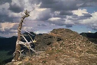
The Southern Oregon Coast Range is the southernmost section of the Oregon Coast Range, in the Pacific Coast Ranges, located in the southwest portion of the state of Oregon, United States, roughly between the Umpqua River and the middle fork of the Coquille River, beyond which are the Klamath Mountains. To the east is the Umpqua Valley and to the west the Pacific Ocean. This approximately 55-mile (89 km)-long mountain range contains mountains as high as 3,547 feet (1,081 m) for Bone Mountain. The mountains are known locally in the Roseburg area as the Callahan Mountains, or simply as The Callahans.

Siuslaw National Forest

The Siuslaw National Forest is a national forest in western Oregon in the United States. Established in 1908, the Siuslaw is made up of a wide variety of ecosystems, ranging from coastal forests to sand dunes.

Klamath Mountains (ecoregion) Ecoregion (WWF)

The Klamath Mountains ecoregion of Oregon and California lies inland and north of the Coast Range ecoregion, extending from the Umpqua River in the north to the Sacramento Valley in the south. It encompasses the highly dissected ridges, foothills, and valleys of the Klamath and Siskiyou Mountains. It corresponds to the Level III ecoregion designated by the Environmental Protection Agency and to the Klamath-Siskiyou forests ecoregion designated by the World Wide Fund for Nature.

Musick Guard Station

The Musick Guard Station is a rustic cabin located in the Umpqua National Forest in western Oregon, United States. It was originally built to house fire crews assigned to patrol the surrounding National Forest. In the 1990s, the United States Forest Service began renting Musick Guard Station to recreational visitors. The Musick Guard Station is listed on the National Register of Historic Places.

References

  1. "North Umpqua Trail" (PDF). Bureau of Land Management. Retrieved December 19, 2012.
Map all coordinates using: OpenStreetMap  ·  Google Maps
Download coordinates as: KML  ·  GPX