See also
| This disambiguation page lists articles associated with the title North York. If an internal link led you here, you may wish to change the link to point directly to the intended article. |
North York is a dissolved municipality within the city of Toronto, Ontario, Canada.
North York may also refer to:
| This disambiguation page lists articles associated with the title North York. If an internal link led you here, you may wish to change the link to point directly to the intended article. |

Ontario is one of the thirteen provinces and territories of Canada. Located in Central Canada, it is Canada's most populous province, with 38.3 percent of the country's population, and is the second-largest province by total area. Ontario is Canada's fourth-largest jurisdiction in total area when the territories of the Northwest Territories and Nunavut are included. It is home to the nation's capital city, Ottawa, and the nation's most populous city, Toronto, which is also Ontario's provincial capital.
Riverdale may refer to:

Toronto is the capital city of the Canadian province of Ontario. With a recorded population of 2,731,571 in 2016, it is the most populous city in Canada and the fourth most populous city in North America. The city is the anchor of the Golden Horseshoe, an urban agglomeration of 9,245,438 people surrounding the western end of Lake Ontario, while the Greater Toronto Area (GTA) proper had a 2016 population of 6,417,516. Toronto is an international centre of business, finance, arts, and culture, and is recognized as one of the most multicultural and cosmopolitan cities in the world.
Scarborough or Scarboro may refer to:

Brampton is a city in the Canadian province of Ontario. Situated in Southern Ontario, it is a suburban city in the Greater Toronto Area (GTA) and part of Peel Region. The city has a population of 593,638 as of the Canada 2016 Census. Brampton is Canada's ninth-most populous municipality, the seventy-seventh largest city in North America and the third most populous city in the Greater Golden Horseshoe Region, behind Toronto and Mississauga.

Markham is a city in the Regional Municipality of York in Southern Ontario, Canada. It is approximately 30 km (19 mi) northeast of Downtown Toronto. In the 2016 Census, Markham had a population of 328,940, which ranked it the largest in York Region, fourth largest in the Greater Toronto Area (GTA), and 16th largest in Canada.

Newmarket is a town and regional seat of the Regional Municipality of York in the Canadian province of Ontario. It is part of Greater Toronto in the Golden Horseshoe region of Southern Ontario.

The Regional Municipality of York, also called York Region, is a regional municipality in Southern Ontario, Canada, between Lake Simcoe and Toronto. It replaced the former York County in 1971, and is part of the Greater Toronto Area and the inner ring of the Golden Horseshoe. The regional government is headquartered in Newmarket.
The Greater Toronto Area (GTA) is the most populous metropolitan area in Canada. It includes the City of Toronto and the regional municipalities of Durham, Halton, Peel, and York. In total, the region contains 25 urban, suburban, and rural municipalities. The Greater Toronto Area begins in Burlington in Halton Region, and extends along Lake Ontario past downtown Toronto eastward to Clarington in Durham Region. Durham Region holds the northernmost municipality in the GTA, although a number of municipalities in the northern periphery of Greater Toronto are situated in York Region.

The Golden Horseshoe is a secondary region of Southern Ontario, Canada, which lies at the western end of Lake Ontario, with outer boundaries stretching south to Lake Erie and north to Lake Scugog and Lake Simcoe. It includes the Greater Toronto Area and adjacent upper-tier municipalities with substantial urban agglomerations. The region is the most densely populated and industrialized in Canada. With a population of 7,826,367 people in its core and 9,245,438 in its greater area, the Golden Horseshoe accounts for over 21 percent of the population of Canada and more than 55 percent of Ontario's population. It is part of the Quebec City–Windsor Corridor, itself part of the Great Lakes Megalopolis.

Yonge Street is a major arterial route in the Canadian province of Ontario connecting the shores of Lake Ontario in Toronto to Lake Simcoe, a gateway to the Upper Great Lakes. Until 1999, the Guinness Book of World Records repeated the popular misconception it was 1,896 km (1,178 mi) long, making it the longest street in the world; this was due to a conflation of Yonge Street with the rest of Ontario's Highway 11. Yonge Street is only 56 kilometres (35 mi) long.

Scarborough is an area of Toronto, Ontario, Canada. Situated atop the Scarborough Bluffs, it occupies the eastern part of the city. Scarborough is contained within the borders of Victoria Park Avenue on the west, Steeles Avenue to the north, Rouge River and the city of Pickering to the east, and Lake Ontario to the south. It borders Old Toronto, East York and North York in the west and the city of Markham in the north. Scarborough was named after the English town of Scarborough, North Yorkshire.

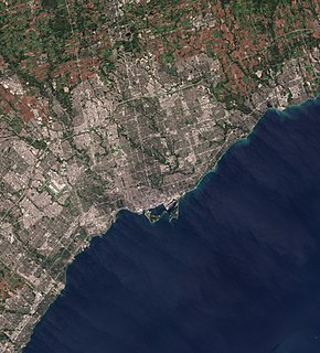
North York is one of the six administrative districts of Toronto, Ontario, Canada. It is located directly north of York, Old Toronto and East York, between Etobicoke to the west and Scarborough to the east. As of the 2016 Census, it had a population of 869,401. It was first created as a township in 1922 out of the northern part of the former township of York, a municipality that was located along the western border of Old Toronto. Following its inclusion in Metropolitan Toronto in 1954, it was one of the fastest-growing parts of the region due to its proximity to Old Toronto. It was declared a borough in 1967, and later became a city in 1979, attracting high-density residences, rapid transit, and a number of corporate headquarters in North York City Centre, its central business district. In 1998, North York was amalgamated with the rest of Metropolitan Toronto to form the new city of Toronto and has since been a secondary economic hub of the city outside Downtown Toronto.
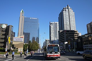
North York City Centre is a central business district in Toronto, Ontario, Canada in the district of North York. It is located along Yonge Street, between just south of Sheppard Avenue northward to Finch Avenue with its focus around Mel Lastman Square, a civic square, and spreads eastwards and westwards a few blocks, generally as far as Doris Avenue and Beecroft Road. The district is a high-density district of condominium and office towers with ground-floor commercial uses along the wide six lanes of Yonge Street.
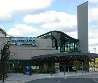
The Toronto Centre for the Arts, previously known as the Ford Centre for the Performing Arts, is a performing arts venue in the North York area of Toronto, Ontario, Canada. It opened in 1993 as the North York Performing Arts Centre and was designed by Canadian architect Eberhard Zeidler for musicals, theatre productions and other performing arts. At opening, North York awarded management of the centre to Livent, which sold the naming rights in 1994 to Ford Motor Company of Canada.

Toronto North was a federal electoral district represented in the House of Commons of Canada from 1904 to 1925. It was located in the city of Toronto in the province of Ontario. This riding was created in 1903 from parts of Toronto Centre, West Toronto and York East ridings.

Downtown Toronto is the main central business district of Toronto, Ontario, Canada. Located entirely within the district of Old Toronto, it is approximately 17 square kilometres in area, bounded by Bloor Street to the northeast and Dupont Street to the northwest, Lake Ontario to the south, the Don Valley to the east, and Bathurst Street to the west. It is also the location of the municipal government of Toronto and the Government of Ontario.

York Centre is a provincial electoral district in Ontario, Canada, that has been the name of ridings in the Legislative Assembly of Ontario three different times. It was created initially in 1955 from the southern part of York North. It was dissolved in 1963 when it was split into three ridings called Yorkview, Downsview and Armourdale. In 1967 it was reconstituted north of Steeles in the township of Markham. This lasted until 1999 when it was dissolved into Markham-Unionville. The name was given to a new riding formed in its original location south of Steeles. It remains as an existing riding today.
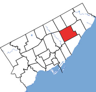
Scarborough Centre is a provincial electoral district in Ontario, Canada, that has been represented in Legislative Assembly of Ontario since 1963.