A geographic coordinate system is a coordinate system that enables every location on Earth to be specified by a set of numbers, letters or symbols. The coordinates are often chosen such that one of the numbers represents a vertical position and two or three of the numbers represent a horizontal position; alternatively, a geographic position may be expressed in a combined three-dimensional Cartesian vector. A common choice of coordinates is latitude, longitude and elevation. To specify a location on a plane requires a map projection.
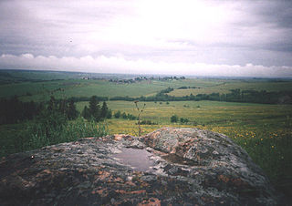
Location of the Northern Ridge (purple) on the topographic map of EuropeIsakova Gora, the highest point of the ridge
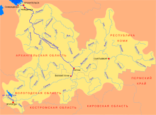
The Northern Ridge, Northern Uvaly, Severnyye Uvaly (Russian: Северные Увалы), is the chain of hills in the northern part of the East European Plain in Russia. The Northern Ridge divides the river basins of the Northern Dvina River (north) and the Volga River (south). The chain is located roughly in the west-east direction, between the source of the Kostroma River and the sources of the Vychegda River and the Kama River. The Northern Ridge is approximately 200km long. Roughly, the chain is limited from the north by the valleys of the Sukhona and the Vychegda, and from the south by the course of the Volga in the west and by the course of the Kama in the east.
Russian is an East Slavic language, which is official in the Russian Federation, Belarus, Kazakhstan and Kyrgyzstan, as well as being widely used throughout Eastern Europe, the Baltic states, the Caucasus and Central Asia. It was the de facto language of the Soviet Union until its dissolution on 25 December 1991. Although nearly three decades have passed since the breakup of the Soviet Union, Russian is used in official capacity or in public life in all the post-Soviet nation-states, as well as in Israel and Mongolia.
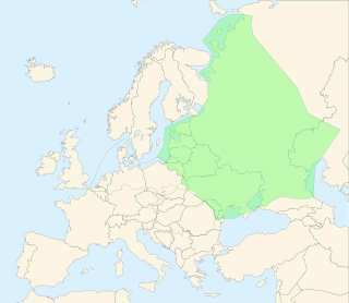
The East European Plain is a vast interior plain extending east of the North/Central European Plain, and comprising several plateaus stretching roughly from 25 degrees longitude eastward. It includes the westernmost Volhynian-Podolian Upland, the Central Russian Upland, and on the eastern border, encompasses the Volga Upland. The plain includes also a series of major river basins such as the Dnepr Basin, the Oka-Don Lowland, and the Volga Basin. Along the southernmost point of the East European Plain are the Caucasus and Crimean mountain ranges. Together with the North European Plain, and covering the Baltics, Moldova, south-eastern Romania, and its most southern expansion - the Danubian Plain in Northern Bulgaria, it constitutes the European Plain, the greatest mountain-free part of the European landscape.
The Northern Dvina is a river in northern Russia flowing through the Vologda Oblast and Arkhangelsk Oblast into the Dvina Bay of the White Sea. Along with the Pechora River to the east, it drains most of Northwest Russia into the Arctic Ocean. It should not be confused with Western Dvina.
Kostroma Oblast is a federal subject of Russia. Its administrative center is the city of Kostroma and its population as of the 2010 Census is 667,562. It was formed in 1944 on the territory detached from neighboring Yaroslavl Oblast.
Vologda Oblast is a federal subject of Russia. Its administrative center is Vologda. Population: 1,202,444. The largest city is Cherepovets, the home of the Severstal metallurgical plant, the largest industrial enterprise in the oblast.
Kirov Oblast is a federal subject of Russia. Its administrative center is the city of Kirov. Population: 1,341,312.
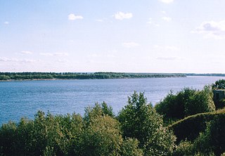
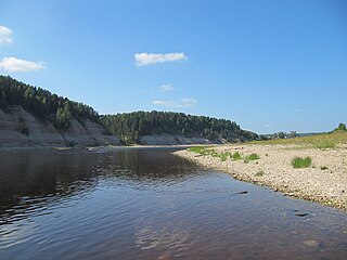
The landscape of the Northern Ridge originates from the Ice Age and has the glacial nature. The hills were polished by the glacier and currently achieve the height of 293 metres (961ft) (in Babushkinsky District, Vologda Oblast). The rivers flow in deep ravines. The principal rivers which have their source in the Northern Ridge are the Yug, the Luza, the Unzha, the Sysola, and the Moloma.
Babushkinsky District is an administrative and municipal district (raion), one of the twenty-six in Vologda Oblast, Russia. It is located in the southeast of the oblast and borders with Nyuksensky District in the north, Kichmengsko-Gorodetsky District in the northeast, Nikolsky District in the east, Kologrivsky and Chukhlomsky Districts of Kostroma Oblast in the south, and with Totemsky District in the west. The area of the district is 7,761 square kilometers (2,997 sq mi). Its administrative center is the rural locality of imeni Babushkina. District's population: 12,779 (2010 Census); 14,994 ; 18,037 (1989 Census). The population of imeni Babushkina accounts for 31.6% of the district's population.
A ravine is a landform that is narrower than a canyon and is often the product of streamcutting erosion. Ravines are typically classified as larger in scale than gullies, although smaller than valleys.
The Yug is a river in Kichmengsko-Gorodetsky, Nikolsky, and Velikoustyugsky Districts of Vologda Oblast and in Podosinovsky District of Kirov Oblast in Russia. It is 574-kilometer (357 mi) long, and the area of its basin is 35,600 square kilometers (13,700 sq mi). The Yug joins the Sukhona near the town of Veliky Ustyug, forming the Northern Dvina, one of the biggest rivers of European Russia.
This page is based on this Wikipedia article Text is available under the CC BY-SA 4.0 license; additional terms may apply. Images, videos and audio are available under their respective licenses.
Related Research Articles
The Sheksna is a river in Belozersky, Kirillovsky, Sheksninsky, and Cherepovetsky Districts of Vologda Oblast in Russia. It is a left tributary of the Volga River. It is 139 kilometres (86 mi) long, and the area of its basin 19,000 square kilometres (7,300 sq mi). The principal tributaries of the Sheksna are the Sizma (left) and the Kovzha (right).
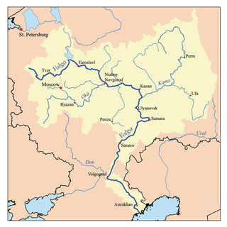
The Kama is a river 1,805 kilometres (1,122 mi) long in Russia. It is the longest left tributary of the Volga and the largest one in discharge. At their confluence, in fact, the Kama is even larger than the Volga.
Vychegda is a river in the European part of Russia, tributary to the Northern Dvina. Its length is about 1,100 kilometres (680 mi). Its source is approximately 310 kilometres (190 mi) west of the northern Ural Mountains. It flows roughly in western direction, through Komi Republic and Arkhangelsk Oblast. The largest city along the Vychegda is Syktyvkar, the capital of Komi Republic. The Viled, the Yarenga, and the Vym are among its main tributaries. The Vychegda flows into the Northern Dvina in Kotlas.
The Sukhona is a river in the European part of Russia, a tributary of the Northern Dvina River. The course of the Sukhona lies in Ust-Kubinsky, Sokolsky, Mezhdurechensky, Totemsky, Tarnogsky, Nyuksensky, and Velikoustyugsky Districts of Vologda Oblast in Russia. It is 558 kilometres (347 mi) long, and the area of its basin 50,300 square kilometres (19,400 sq mi). The Sukhona joins the Yug near the town of Veliky Ustyug, forming the Northern Dvina, one of the biggest rivers of European Russia.
The Volga Region is a historical region in Russia that encompasses the drainage basin of the Volga River, the longest river in Europe, in central and southern European Russia.
The Suda is a river in Babayevsky, Kaduysky, and Cherepovetsky Districts of Vologda Oblast in Russia. It flows into the Rybinsk Reservoir of the Volga River. It is 184 kilometres (114 mi) long, with a drainage basin of 13,500 square kilometres (5,200 sq mi) and an average discharge of 134 cubic metres per second (4,700 cu ft/s). Its main tributaries are the Shogda, the Andoga, the Kolp, the Voron and the Petukh rivers.
The Timan Ridge is a highland in the far north of European Russia. Most of the Timan Ridge is situated in the Komi Republic, but the northernmost part is in Nenets Autonomous Okrug and Arkhangelsk Oblast. The highest point in the Timan Ridge is Chetlassky Kamen.
Northwest Russia or Northern European Russia can be roughly defined as that part of European Russia bounded by Finland, the Arctic Ocean, the Ural Mountains and the east-flowing part of the Volga River. Although it was never a political unit there is some reason for treating it as a distinct region.
Gryazovetsky District is an administrative and municipal district (raion), one of the twenty-six in Vologda Oblast, Russia. It is located in the south of the oblast and borders with Mezhdurechensky District in the north, Soligalichsky and Buysky Districts of Kostroma Oblast in the east, Lyubimsky and Pervomaysky Districts of Yaroslavl Oblast in the south, Poshekhonsky District, also of Yaroslavl Oblast, in the southeast, and with Vologodsky District in the northwest. The area of the district is 5,030 square kilometers (1,940 sq mi). Its administrative center is the town of Gryazovets. Population: 36,820 (2010 Census); 41,644 ; 47,136 (1989 Census). The population of Gryazovets accounts for 42.2% of the district's total population.
Nikolsky District is an administrative and municipal district (raion), one of the twenty-six in Vologda Oblast, Russia. It is located in the southeast of the oblast and borders with Kichmengsko-Gorodetsky District in the north, Vokhomsky District of Kostroma Oblast in the east, Pavinsky, Pyshchugsky, Mezhevskoy, and Kologrivsky Districts of Kostroma Oblast in the south, Babushkinsky District in the southwest, and with Nyuksensky District in the west. The area of the district is 7,476 square kilometers (2,886 sq mi). Its administrative center is the town of Nikolsk. Population: 22,414 (2010 Census); 26,461 ; 31,437 (1989 Census). The population of Nikolsk accounts for 38.0% of the district's total population.
Totemsky District is an administrative and municipal district (raion), one of the twenty-six in Vologda Oblast, Russia. It is located in the east of the oblast and borders with Verkhovazhsky and Tarnogsky Districts in the north, Nyuksensky District in the northeast, Babushkinsky District in the east, Chukhlomsky and Soligalichsky Districts of Kostroma Oblast in the south, Mezhdurechensky and Sokolsky Districts in the southwest, and with Syamzhensky District in the west. The area of the district is 8,200 square kilometers (3,200 sq mi). Its administrative center is the town of Totma. Population: 23,315 (2010 Census); 26,392 ; 27,907 (1989 Census). The population of Totma accounts for 42.0% of the district's total population.
The Sharzhenga is a river in Nyuksensky, Babushkinsky, and Nikolsky Districts of Vologda Oblast in Russia. It is a left tributary of the Yug River. It is 183 kilometres (114 mi) long, and the area of its basin 1,500 square kilometres (580 sq mi). The main tributary is the Andanga River (right).
The Tolshma is a river in Soligalichsky District of Kostroma Oblast and Totemsky District of Vologda Oblast in Russia. It is a right tributary of the Sukhona River. The river is 157 kilometres (98 mi) long. The area of its basin is 1,540 square kilometres (590 sq mi). The principal tributary is the Yelshma River (right).
The Lezha is a river in Gryazovetsky, Vologodsky, and Mezhdurechensky Districts of Vologda Oblast in Russia. It is a right tributary of the Sukhona River. It is 178 kilometres (111 mi) long, and the area of its basin 3,550 square kilometres (1,370 sq mi). The principal tributaries are the Senga (left), the Velikaya (right), and the Komela (left).