Northumberlandia

Last updated

Northumberlandia under construction in August 2011 Northumberlandia 001.jpg
Northumberlandia under construction in August 2011
The head pictured from below showing lips, nostrils, eyes and forehead Northumberlandia - facial shot.jpg
The head pictured from below showing lips, nostrils, eyes and forehead

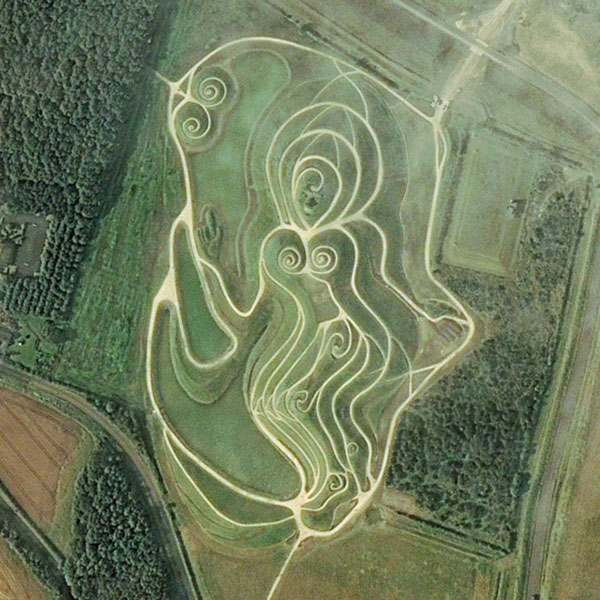
Northumberlandia (the "Lady of the North") is a huge land art sculpture in the shape of a reclining female figure, which was completed in 2012, near Cramlington, Northumberland, northern England. It is in the care of Northumberland Wildlife Trust. [1]

Contents

Made of 1.5 million tonnes of earth from neighbouring Shotton Surface Mine, it is 34 metres (112 feet) high and 400 metres (1,300 feet) long, set in a 19 hectares (47 acres) public park. Its creators claim that it is the largest land sculpture in female form in the world. [2]

When constructed, it was intended to be a major tourist attraction, with the developers hoping that it would attract an additional 200,000 visitors a year to Northumberland. [3] It was officially opened by Anne, Princess Royal on 29 August 2012. [4] A day-long Community Opening Event on 20 October 2012 marked the park becoming fully open to the public. [2]

Development

Relief map of Northumberlandia Northumberlandia LIDAR.jpg
Relief map of Northumberlandia
A map of Northumberlandia Northumberlandia map.svg
A map of Northumberlandia

Designed by American landscape architect Charles Jencks, [5] the sculpture was built on the Blagdon Estate, owned by Matt Ridley, a journalist, businessman and author of The Red Queen: Sex and the Evolution of Human Nature .[ citation needed ]

The £2.5 million cost was borne by the Blagdon Estate and the Banks Group, who carried out the construction work. The construction is part of the development of an adjacent open-cast coal mine at Shotton. For this project, it was decided to use part of the excavated material to make a land sculpture rather than return it all to the surface mine, as is normally done at the end of such operations.

Condition

In April 2023, Northumberland Wildlife Trust reported that the work was suffering excessive wear, due to visitors failing to stay on the designated paths. Extra signage is planned to discourage this, as well as repairs which, the Trust said, "will take years to complete". [1]

See also

Related Research Articles

<span class="mw-page-title-main">Northumberland</span> County in northern England

Northumberland is a ceremonial and historic county in North East England, bordering Scotland. The ceremonial county is governed by Northumberland County Council, a unitary authority. The county borders the Scottish Borders to the north, the North Sea to the east, Tyne and Wear and County Durham to the south, and Cumbria to the west. The historic county covers this area and the parts of Tyne and Wear north of the River Tyne.

<span class="mw-page-title-main">Matt Ridley</span> British journalist and businessman

Matthew White Ridley, 5th Viscount Ridley,, is a British science writer, journalist and businessman. He is known for his writings on science, the environment, and economics and has been a regular contributor to The Times newspaper. Ridley was chairman of the UK bank Northern Rock from 2004 to 2007, during which period it experienced the first run on a British bank in 130 years. He resigned, and the bank was bailed out by the UK government; this led to its nationalisation.

<span class="mw-page-title-main">Prudhoe</span> Town in Northumberland, England

Prudhoe is a town in south Northumberland, England, about 11 miles (18 km) west of the city of Newcastle upon Tyne and just south of the River Tyne. Situated on a steep, north-facing hill in the Tyne valley, Prudhoe had a population of 11,675 at the 2011 census. It has largely become a commuter town for nearby Newcastle.

<span class="mw-page-title-main">Rutland Water</span> Reservoir in Rutland, England

Rutland Water is a reservoir in Rutland, England, east of Rutland's county town, Oakham. It is filled by pumping from the River Nene and River Welland, and provides water to the East Midlands. By surface area it is the largest reservoir in England, but its capacity is exceeded by that of Kielder Water in Northumberland. Its maximum depth is 33m.

<i>Angel of the North</i> Sculpture by Antony Gormley in northern England

The Angel of the North is a contemporary sculpture by Antony Gormley, located in Gateshead, Tyne and Wear, England. Completed in 1998, it is believed to be the largest sculpture of an angel in the world and is viewed by an estimated 33 million people every year due to its proximity to the A1 and A167 roads and the East Coast Main Line. The design of the Angel, like many of Gormley's works, is based on Gormley's own body. The COR-TEN weathering steel material gives the sculpture its distinctive rusty, oxidised colour. It stands 20 metres (66 ft) tall with a wingspan of 54 metres (177 ft), larger than that of a Boeing 757 aircraft. The vertical ribs on its body and wings act as an external skeleton which direct oncoming wind to the sculpture's foundations, allowing it to withstand wind speeds of over 100 miles per hour (160 km/h).

<span class="mw-page-title-main">Blyth, Northumberland</span> Town in Northumberland, England

Blyth is a town and civil parish in southeast Northumberland, England. It lies on the coast, to the south of the River Blyth and is approximately 13 miles (21 km) northeast of Newcastle upon Tyne. It had a population of 37,339 in the 2011 Census.

<span class="mw-page-title-main">Cramlington</span> Human settlement in England

Cramlington is a town and civil parish in Northumberland, England, 6 miles north of Newcastle upon Tyne, and 10 miles north of its city centre. The name suggests a probable founding by the Danes or Anglo-Saxons. The population was 29,405 as of 2011 census data from Northumberland County Council. It sits on the border between Northumberland and North Tyneside with the traffic interchange at Moor Farm, Annitsford, linking the two areas.

<span class="mw-page-title-main">Petworth House</span> Country house in Petworth, West Sussex

Petworth House in the parish of Petworth, West Sussex, England, is a late 17th-century Grade I listed country house, rebuilt in 1688 by Charles Seymour, 6th Duke of Somerset, and altered in the 1870s to the design of the architect Anthony Salvin. It contains intricate wood-carvings by Grinling Gibbons. It is the manor house of the manor of Petworth. For centuries it was the southern home for the Percy family, earls of Northumberland.

<span class="mw-page-title-main">Seaton Delaval</span> Human settlement in England

Seaton Delaval is a village and former civil parish, now in the parish of Seaton Valley, in Northumberland, England, with a population of 4,371. The largest of the five villages in Seaton Valley, it is the site of Seaton Delaval Hall, completed by Sir John Vanbrugh in 1727.

<span class="mw-page-title-main">Seaton Sluice</span> Human settlement in England

Seaton Sluice is a village in Northumberland. It lies on the coast at the mouth of the Seaton Burn, midway between Whitley Bay and Blyth. It has a population of about 3,000 people.

<span class="mw-page-title-main">Banks Group</span>

The Banks Group is a family owned business headquartered in Durham, but working across Scotland and the North of England, established in 1976. Banks develops and operates in a variety of business areas including property development, renewables generation, flexible energy generation and storage, and mineral extraction and infrastructure services. The Banks Group was founded by Harry Banks OBE DL with his brothers Graham Banks, Joe Banks and Bruce Banks.

<span class="mw-page-title-main">Blagdon Hall</span>

Blagdon Hall is a privately owned English country house near Cramlington in Northumberland. It is a Grade I listed building. The house and estate have been in the ownership of the White Ridley family since 1698. The present Viscount Ridley is the science writer and hereditary peer Matt Ridley.

<span class="mw-page-title-main">St Nicholas Hospital, Newcastle upon Tyne</span> Hospital in England

St Nicholas Hospital is an NHS psychiatric hospital located in Gosforth, Newcastle upon Tyne, England, UK. The entrance is located on Jubilee Road. The buildings range from Victorian-era to modern facilities and occupies 12 hectares of land. It is managed by Cumbria, Northumberland, Tyne and Wear NHS Foundation Trust.

<span class="mw-page-title-main">Parkside Middle School, Cramlington</span> Middle school in Cramlington, Northumberland, England

Parkside Middle School was a school in Cramlington, United Kingdom from its foundation in 1909 until 2008, when it closed as middle school functions in the town were transferred to Cramlington Learning Village.

Open-pit coal mining in the United Kingdom is in decline. Output has fallen every year since 2010. In 2010, the United Kingdom was forecast to produce about ten million tonnes of coal a year from open-pit mines. Most came from Scotland, with the largest operator there being the Scottish Coal subsidiary of Scottish Resources Group. Actual production in 2010 was over 13 million tonnes but this has declined to less than 8 million tonnes in 2014. Deep coal mining stopped completely at the end of 2015 and the UK is planning to phase out the use of coal to produce electricity by 2024.

<span class="mw-page-title-main">St Aidan's</span> Country park in West Yorkshire, England

St Aidan's is a 355 hectare nature park located between Leeds and Castleford in West Yorkshire, England. The land was formerly an opencast coal mining area that was flooded in 1988, after the riverbank collapsed. Repairs and remediation required their own Act of Parliament to allow the necessary works to go ahead. Mining ceased at St Aidan's in 2002.

Northumbria Healthcare NHS Foundation Trust is an NHS foundation trust which provides hospital and community health services in North Tyneside and hospital, community health and adult social care services in Northumberland.

<span class="mw-page-title-main">Shotton Surface Mine</span>

Shotton Surface Mine was an open cast coal mine located on the estate of Blagdon Hall, Northumberland, UK, operated by Banks Group. The mine was granted permission by the government in 2007, despite being refused permission by Blyth Valley Council, with an initial agreement to mine 3.4 million tonnes of coal, 2 million tonnes of shale and 750,000 tonnes of fireclay. This was subsequently extended by two years in 2011 to allow an additional 2 million tonnes of coal to be mined, set to end in 2016. An additional expansion approved in 2014 saw two new pits being opened on the site, Shotton Triangle and Shotton South West, with the end date pushed back a year to October 2017; the land was expected to be restored by 2019. The mine eventually ceased production in summer 2020.

<span class="mw-page-title-main">The Land Trust</span> British charity

The Land Trust is a British charity, based in Warrington, Cheshire, which owns or manages open spaces restored from derelict land for public benefit. Its vision is "to improve the quality of people’s lives by creating sustainable, high quality green spaces that deliver environmental, social and economic benefits".

Cramlington Aerodrome was a military airfield established in Northumberland during the First World War. It became a civil airfield serving the Tyneside area of north-east England and operated until 1935, when it was replaced by Woolsington Airport, now known as Newcastle International Airport.

References

  1. 1 2 Brown, Mark (30 April 2023). "'She is looking worse for wear': visitors take a toll on the Lady of the North". The Guardian.
  2. 1 2 "Northumberlandia: The naked lady of Cramlington". BBC News. 1 September 2012. Retrieved 2 September 2012.
  3. "Work begins on 'Goddess of the North' in Northumberland". BBC News website. 8 April 2010. Retrieved 21 August 2011.
  4. "Northumberlandia: Princess Royal opens naked sculpture". BBC News. 3 September 2012. Retrieved 3 September 2012.
  5. Gilbert, Jonathan (17 June 2011). "Coming to the UK -- a half-mile long woman's body". Reuters website. Retrieved 21 August 2011.

55°5′18.2″N1°37′41.1″W / 55.088389°N 1.628083°W / 55.088389; -1.628083