Northwesternmost point of the Lake of the Woods

Last updated

The northwesternmost point of the Lake of the Woods was a critical landmark for the boundary between United States territory and the British possessions to the north. This point, on the shore of the Lake of the Woods, was referred to in the Treaty of Paris in 1783 [1] and in later treaties including the Treaty of 1818. The point lies at the corner of the Northwest Angle in the U.S. state of Minnesota, and is thus the northernmost point of the contiguous United States. After Canadian Confederation, the point became the basis for the border between the Canadian provinces of Manitoba and Ontario.

Example demonstrating how the most northwest point of the Lake of the Woods was determined. If the line intersects any part of the lake, it is determined not to be the most northwest point of the Lake of the Woods. NorthwesternPointLakeoftheWoods.svg
Example demonstrating how the most northwest point of the Lake of the Woods was determined. If the line intersects any part of the lake, it is determined not to be the most northwest point of the Lake of the Woods.

The "northwesternmost point" of the lake had not yet been identified when it was referenced in treaties defining the border between the US and Britain; it was simply an easily described abstraction based on a large landmark. The best maps at the time of the original negotiation depicted the lake as a simple oval. [2] However, although the southern portion of the lake is easily mapped, to the north it becomes a complex tangle of bays, peninsulas, and islands, with many adjacent bodies of water separated or connected by narrow isthmuses or straits. An 1822 survey crew declared the referenced point impossible to determine. [2] In 1824, British explorer David Thompson was hired to identify it. Thompson mapped the lake and found four possibilities, but did not conclusively declare one location. [2]

Surveyors report (1912) of the northwesternmost point of Lake of the Woods Northwest Angle 1912.jpg
Surveyors report (1912) of the northwesternmost point of Lake of the Woods

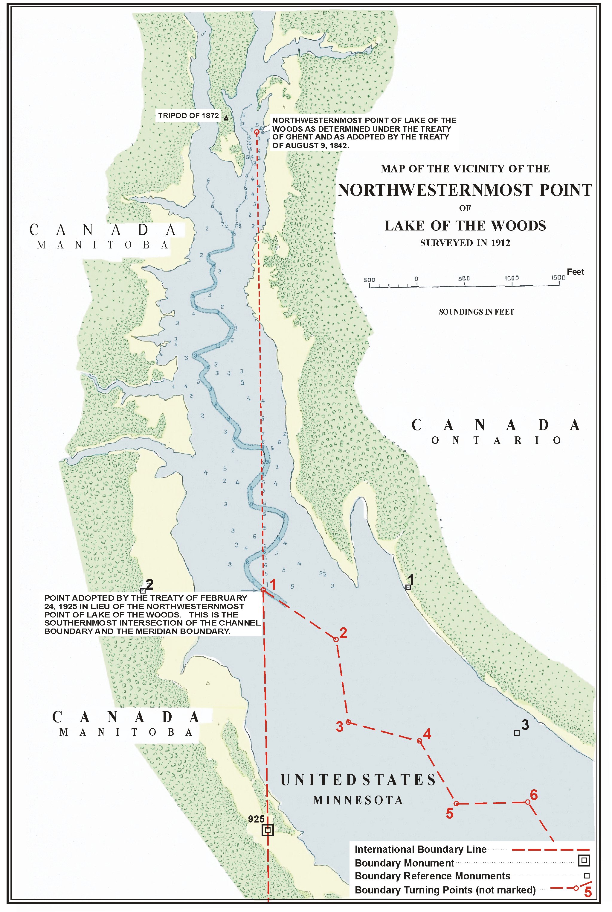
In 1825, Johann Ludwig Tiarks, a German astronomer in British service, surveyed the lake. Tiarks identified two possibilities for the northwesternmost point on the lake, based on Thompson's maps: the Angle Inlet and Rat Portage. To determine which point was the most northwestern, he drew a line from each point in the southwest–northeast direction. If the line intersected the lake at any point, it was not the most northwestern point, as shown in the example diagram here. Tiarks determined that the only such line that did not intersect the lake was at the edge of a pond on the Angle Inlet. [3] (A 1940 academic study documents this point as being in the immediate vicinity of 49°23′51.324″N95°9′12.20783″W / 49.39759000°N 95.1533910639°W / 49.39759000; -95.1533910639 (NAD83).) [4] [5]

Under the 1783 treaty, the international border would have run due west from this point to the Mississippi River. As this was determined to be geographically impossible (the Mississippi begins further south), under the 1818 treaty the international border instead ran from the point determined by Tiarks, to the 49th parallel. (It was not known at the time whether that was to the north or – in fact – the south.) [2] From there it ran due west to the Rocky Mountains (and later, the Pacific coast).

Tiarks's point, however, created problems, because the 1818 treaty called for the border to run directly north–south from it. South of that point, the channel of the Northwest Angle Inlet meandered east and west, crossing the border five times, thereby creating two small enclaves of water areas totaling two and a half acres that belonged to the United States but were surrounded by Canadian waters. A 1925 treaty addressed this by adopting the southernmost of the points where the channel and the border intersected – approximately 5,000 ft (1,500 m) south of Tiarks's point – as the new "northwesternmost point". [4]

The new northwesternmost point thus became 49°23′4.14″N95°9′11.34″W / 49.3844833°N 95.1531500°W / 49.3844833; -95.1531500 , based on the NAD27 datum, [6] which is equivalent to 49°23′4.12373″N95°9′12.20783″W / 49.3844788139°N 95.1533910639°W / 49.3844788139; -95.1533910639 under the modern NAD83 datum. [7]

Related Research Articles

<span class="mw-page-title-main">Angle Township, Lake of the Woods County, Minnesota</span> Township in Minnesota, United States

Angle Township is a township in Lake of the Woods County, Minnesota, United States. The population was 119 at the 2010 census. At 49.22° north latitude, it is the northernmost township in Minnesota and the Contiguous United States. The unincorporated communities of Oak Island, Angle Inlet and Penasse are located in the township.

<span class="mw-page-title-main">Treaty of Paris (1783)</span> Agreement ending the American Revolutionary War

The Treaty of Paris, signed in Paris by representatives of King George III of Great Britain and representatives of the United States on September 3, 1783, officially ended the American Revolutionary War and recognized the Thirteen Colonies, which had been part of colonial British America, as an independent, sovereign nation.

<span class="mw-page-title-main">Webster–Ashburton Treaty</span> 1842 border resolution treaty between British Canada and the United States

The Webster–Ashburton Treaty, signed August 9, 1842, was a treaty that resolved several border issues between the United States and the British North American colonies. Signed under John Tyler's presidency, it resolved the so-called Aroostook War. The provisions of the treaty included:

<span class="mw-page-title-main">Northwest Angle</span> Part of Minnesota, separated from the rest of the state by the Lake of the Woods

The Northwest Angle, known simply as the Angle by locals, and coextensive with Angle Township, is a pene-exclave of northern Lake of the Woods County, Minnesota. Except for surveying errors, it is the only place in the contiguous United States north of the 49th parallel, which forms the border between the U.S. and Canada from the Northwest Angle westward to the Strait of Georgia. The land area of the Angle is separated from the rest of Minnesota by Lake of the Woods, but shares a land border with Canada. It is one of six non-island locations in the 48 contiguous states that are practical exclaves of the U.S. It is the northernmost township in Minnesota and contains the northernmost point in the contiguous 48 states. The unincorporated community of Angle Inlet is in the Northwest Angle.

<span class="mw-page-title-main">Lake of the Woods</span> Lake on the United States–Canada border

Lake of the Woods is a lake occupying parts of the Canadian provinces of Ontario and Manitoba and the U.S. state of Minnesota. Lake of the Woods is over 70 miles (110 km) long and wide, containing more than 14,552 islands and 65,000 miles (105,000 km) of shoreline. It is fed by the Rainy River, Shoal Lake, Kakagi Lake and other smaller rivers. The lake drains into the Winnipeg River and then into Lake Winnipeg. Ultimately, its outflow goes north through the Nelson River to Hudson Bay.

The 49th parallel north is a circle of latitude that is 49° north of Earth's equator. It crosses Europe, Asia, the Pacific Ocean, North America, and the Atlantic Ocean.

<span class="mw-page-title-main">Republic of Indian Stream</span> Short-lived 1830s republic in present-day U.S. state of New Hampshire

The Republic of Indian Stream or the Indian Stream Republic was an unrecognized republic in North America, along the section of the border that divides the current Canadian province of Quebec from the U.S. state of New Hampshire. It existed from July 9, 1832, to August 5, 1835. Described as "Indian Stream Territory, so-called" by the United States census-taker in 1830, the area was named for Indian Stream, a small watercourse. It had an organized elected government and constitution and served about three hundred citizens.

<span class="mw-page-title-main">Canada–United States border</span> International border

The Canada–United States border is the longest international border in the world. The boundary is 8,891 km (5,525 mi) long. The land border has two sections: Canada's border with the contiguous United States to its south, and with the U.S. state of Alaska to its west. The bi-national International Boundary Commission deals with matters relating to marking and maintaining the boundary, and the International Joint Commission deals with issues concerning boundary waters. The agencies responsible for facilitating legal passage through the international boundary are the Canada Border Services Agency (CBSA) and U.S. Customs and Border Protection (CBP).

<span class="mw-page-title-main">Treaty of 1818</span> 1818 treaty which established the 49th parallel as the western US-Canada border

The Convention respecting fisheries, boundary and the restoration of slaves, also known as the London Convention, Anglo-American Convention of 1818, Convention of 1818, or simply the Treaty of 1818, is an international treaty signed in 1818 between the United States and the United Kingdom. This treaty resolved standing boundary issues between the two nations. The treaty allowed for joint occupation and settlement of the Oregon Country, known to the British and in Canadian history as the Columbia District of the Hudson's Bay Company, and including the southern portion of its sister district New Caledonia.

<span class="mw-page-title-main">Dixon Entrance</span> Strait on the western Canada–United States border

The Dixon Entrance is a strait about 80 kilometers (50 mi) long and wide in the Pacific Ocean at the Canada–United States border, between the U.S. state of Alaska and the province of British Columbia in Canada. The Dixon Entrance is part of the Inside Passage shipping route. It forms part of the maritime boundary between the U.S. and Canada, although the location of that boundary here is disputed.

White Rock is an unincorporated community in Huron County in the U.S. state of Michigan. The community is located within Sherman Township. As an unincorporated community, White Rock has no legal autonomy, defined boundaries, or population statistics of its own. It is located at 43°42′35″N82°36′31″W, about three miles north of Forestville and about nine miles south of Harbor Beach on M-25 at the junction with White Rock Road.

<span class="mw-page-title-main">Pembina Region</span>

The Pembina Region, also referred to as the Pembina District and Pembina Department, is the historic name of an unorganized territory of land that was ceded to the United States in 1818. The area included the portions of what became the States of Minnesota, North Dakota, and South Dakota lying within the Hudson Bay drainage basin. The area included settlements in the Pembina River area. The region was formerly part of British Rupert's Land, granted by British royal charter to the Hudson's Bay Company. After the Selkirk Concession and establishment of the agricultural Red River Colony in 1812, the area was governed as the District of Assiniboia. The Treaty of 1818 de jure transferred the region south of the 49th parallel to the United States from the British. Settlements south of the boundary continued to be de facto administered as part of Assiniboia until at least 1823.

<span class="mw-page-title-main">Isle Phelipeaux</span> Phantom island in Lake Superior

Isle Phelipeaux or IslePhilippeaux – also called Isle Minong – is a phantom island supposedly located in Lake Superior. In the late 18th and early 19th centuries, it was believed to be real, and was shown on maps of the era. The island "Phelipeaux" is mentioned in the 1783 Treaty of Paris as a landmark defining the border between the United States and what would later become Canada.

<span class="mw-page-title-main">Territorial evolution of the United States</span> Changes and expansion of the territory of the United States

The United States of America was formed after thirteen British colonies in North America declared independence from the British Empire on July 4, 1776. In the Lee Resolution, passed by the Second Continental Congress two days prior, the colonies resolved that they were free and independent states. The union was formalized in the Articles of Confederation, which came into force on March 1, 1781, after being ratified by all 13 states. Their independence was recognized by Great Britain in the Treaty of Paris of 1783, which concluded the American Revolutionary War. This effectively doubled the size of the colonies, now able to stretch west past the Proclamation Line to the Mississippi River. This land was organized into territories and then states, though there remained some conflict with the sea-to-sea grants claimed by some of the original colonies. In time, these grants were ceded to the federal government.

<span class="mw-page-title-main">Elm Point, Minnesota</span> Uninhabited cape and exclave of the United States

Elm Point, Minnesota, is a small uninhabited cape and a practical exclave of the United States in Lake Township, Roseau County, Minnesota, United States. It is surrounded on the west, south, and east by Lake of the Woods, and on the north by the Canadian First Nation community of Buffalo Point in southeastern Manitoba. Part of Elm Point is privately owned and part of it is state land managed by the Department of Natural Resources as part of the Border Wildlife Management Area. It is located southwest of the much larger exclave known as the Northwest Angle. There is a line of felled trees marking the international border, which runs nominally along the 49th parallel, although in this area it runs slightly to the south due to 19th-century surveying errors.

Northwest Angle 33 First Nation is an Ojibwe or Ontario Anishinaabe First Nation band government who reside in Kenora District, Ontario near Sioux Narrows of Lake of the Woods.

Buffalo Point First Nation is an Ojibwa or Saulteaux First Nations located in the southeastern corner of Manitoba, along the shores of Lake of the Woods. It is bordered largely by the unorganized portion of Division No. 1, Manitoba, and also has smaller borders with the Rural Municipality of Piney, as well as the northeast corner of Roseau County, Minnesota.

<span class="mw-page-title-main">Borders of Canada</span>

The borders of Canada include:

John Lewis Tiarks, FRS was the British astronomer to the North American Boundary Line Commission.

Johann Ludwig Tiarks was a German mathematician and astronomer who was involved in determining the boundary between the United States and British North America.

References

  1. "The Paris Peace Treaty of 1783". University of Oklahoma College of Law. 2009. Archived from the original on 2008-09-29. Retrieved 28 Oct 2009.
  2. 1 2 3 4 Lori Nelson. "Drawing the Line… The Canada-U.S. Border" . Retrieved 15 Oct 2009.
  3. William E. Lass (1980). Minnesota's Boundary with Canada: Its Evolution Since 1783. Minnesota Historical Society Press. p. 48. ISBN   0-87351-153-0 . Retrieved 15 August 2011.
  4. 1 2 Boggs, Samuel Whittemore (1940). International boundaries: a study of boundary functions and problems. Columbia University Press. pp. 48–49. ISBN   9780404009199 . Retrieved 2013-04-27.
  5. "Map of the vicinity of the northwesternmost point of Lake of the Woods" . Retrieved 2013-08-19.
  6. International Boundary Commission (1937). "Joint Report upon the Survey and Demarcation of the Boundary between the United States and Canada from the Gulf of Georgia to the Northwesternmost Point of Lake of the Woods" (Document). U.S. Govt. print. off. p. 332. hdl:2027/mdp.39015027937153.
  7. United States National Geodetic Survey. "North American Datum Conversion, NAD 27 to NAD 83, NADCON Program Version 2.11" . Retrieved 2013-10-28.

49°23′04″N95°09′12″W / 49.384479°N 95.153391°W / 49.384479; -95.153391