Norwich Airport (Kansas)

Last updated
Norwich Airport
Summary
Airport type Public
Owner City of Norwich
Serves Norwich, Kansas
Elevation  AMSL 1,494 ft / 455 m
Coordinates 37°27′20″N097°50′06″W / 37.45556°N 97.83500°W / 37.45556; -97.83500 Coordinates: 37°27′20″N097°50′06″W / 37.45556°N 97.83500°W / 37.45556; -97.83500
Map
USA Kansas location map.svg
Airplane silhouette.svg
49K
Location of airport in Kansas
Runways
Direction Length Surface
ft m
17/35 3,230 985 Turf
Statistics (2011)
Aircraft operations 470
Based aircraft 8

Norwich Airport( FAA LID : 49K) is a city owned, public use airport located one  nautical mile (2  km) east of the central business district of Norwich, a city in Kingman County, Kansas, United States. [1]

Federal Aviation Administration United States Government agency dedicated to civil aviation matters

The Federal Aviation Administration (FAA) is a governmental body of the United States with powers to regulate all aspects of civil aviation in that nation as well as over its surrounding international waters. Its powers include the construction and operation of airports, air traffic management, the certification of personnel and aircraft, and the protection of U.S. assets during the launch or re-entry of commercial space vehicles. Powers over neighboring international waters were delegated to the FAA by authority of the International Civil Aviation Organization.

A location identifier is a symbolic representation for the name and the location of an airport, navigation aid, or weather station, and is used for manned air traffic control facilities in air traffic control, telecommunications, computer programming, weather reports, and related services.

Airport location where aircraft take off and land

An airport is an aerodrome with extended facilities, mostly for commercial air transport. Airports often have facilities to store and maintain aircraft, and a control tower. An airport consists of a landing area, which comprises an aerially accessible open space including at least one operationally active surface such as a runway for a plane to take off or a helipad, and often includes adjacent utility buildings such as control towers, hangars and terminals. Larger airports may have airport aprons, taxiway bridges, air traffic control centres, passenger facilities such as restaurants and lounges, and emergency services. In some countries, the US in particular, they also typically have one or more fixed-base operators, serving general aviation.

Contents

Facilities and aircraft

Norwich Airport covers an area of 10 acres (4 ha) at an elevation of 1,494 feet (455 m) above mean sea level. It has one runway designated 17/35 with a turf surface measuring 3,230 by 80 feet (985 x 24 m). [1]

Acre unit of area

The acre is a unit of land area used in the imperial and US customary systems. It is traditionally defined as the area of one chain by one furlong, which is exactly equal to 10 square chains, ​1640 of a square mile, or 43,560 square feet, and approximately 4,047 m2, or about 40% of a hectare. Based upon the International yard and pound agreement of 1959, an acre may be declared as exactly 4,046.8564224 square metres. The acre is a statute measure in the United States and was formerly one in the United Kingdom and almost all countries of the former British Empire, although informal use continues.

Hectare metric unit of area

The hectare is an SI accepted metric system unit of area equal to a square with 100-metre sides, or 10,000 m2, and is primarily used in the measurement of land. There are 100 hectares in one square kilometre. An acre is about 0.405 hectare and one hectare contains about 2.47 acres.

Elevation Height of a geographic location above a fixed reference point

The elevation of a geographic location is its height above or below a fixed reference point, most commonly a reference geoid, a mathematical model of the Earth's sea level as an equipotential gravitational surface . The term elevation is mainly used when referring to points on the Earth's surface, while altitude or geopotential height is used for points above the surface, such as an aircraft in flight or a spacecraft in orbit, and depth is used for points below the surface.

For the 12-month period ending September 23, 2011, the airport had 470 general aviation aircraft operations, an average of 39 per month. At that time there were eight aircraft based at this airport: 75% single-engine and 25% ultralight. [1]

General aviation civil use of aircraft excluding commercial transportation

General Aviation (GA) represents the 'private transport' and recreational flying component of aviation.

Aircraft engine Engine designed for use in powered aircraft

An aircraft engine is a component of the propulsion system for an aircraft that generates mechanical power. Aircraft engines are almost always either lightweight piston engines or gas turbines, except for small multicopter UAVs which are almost always electric aircraft.

Related Research Articles

Hillside Airport is a public use airport located four nautical miles northeast of the central business district of Stilwell, a town in Johnson County, Kansas, United States.

Newton City/County Airport airport in Kansas, United States of America

Newton City-County Airport is three miles east of Newton, in Harvey County, Kansas. It is owned by the City of Newton and Harvey County.

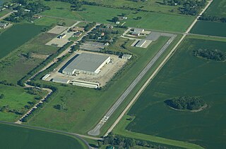
Hamilton Field was formerly a public-use airport located two nautical miles east of the central business district of Derby, a city in Sedgwick County, Kansas, United States. The land has been subdivided for residential use, and is no longer an operating airport. It was privately owned by Hamilton Land Group LLC.

Unionville Municipal Airport is a city-owned, public-use airport located three nautical miles (6 km) north of the central business district of Unionville, a city in Putnam County, Missouri, United States. It was previously known as Municipal Airport and was also known as Unionville Airport.

Posey Field airport in Alabama, United States of America

Posey Field is a city-owned public-use airport located three nautical miles northeast of the central business district of Haleyville, a city in Winston County, Alabama, United States.

Headland Municipal Airport airport in Alabama, United States

Headland Municipal Airport is a city-owned, public-use airport located two nautical miles northeast of the central business district of Headland, a city in Henry County, Alabama, United States.

Scottsboro Municipal Airport airport in Alabama, United States of America

Scottsboro Municipal Airport, also known as Word Field, is a city-owned public-use airport located two nautical miles northeast of the central business district of Scottsboro, a city in Jackson County, Alabama, United States. According to the FAA's National Plan of Integrated Airport Systems for 2009–2013, it is categorized as a general aviation facility.

Garnett Municipal Airport is a city-owned public-use airport located two nautical miles east of the central business district of Garnett, a city in Anderson County, Kansas, United States.

Humboldt Municipal Airport (Iowa) airport in Iowa, United States of America

Humboldt Municipal Airport is a city-owned public-use airport located one nautical mile (1.85 km) west of the central business district of Humboldt, a city in Humboldt County, Iowa, United States. According to the FAA's National Plan of Integrated Airport Systems for 2009–2013, it is classified as a general aviation airport.

Freddie Jones Field is a city-owned, public-use airport located five nautical miles southeast of the central business district of Linden, a city in Marengo County, Alabama, United States.

Stockton Municipal Airport (Kansas) airport in Kansas, United States of America

Stockton Municipal Airport is a city-owned, public-use airport located three nautical miles (6 km) southwest of the central business district of Stockton, a city in Rooks County, Kansas, United States.

Eureka Municipal Airport (Kansas) airport in Kansas, United States of America

Eureka Municipal Airport, also known as Lt. William M. Milliken Airport, is a city-owned, public-use airport located two nautical miles (4 km) north of the central business district of Eureka, a city in Greenwood County, Kansas, United States. It is included in the National Plan of Integrated Airport Systems for 2011–2015, which categorized it as a general aviation facility.

Stanton County Municipal Airport airport in Kansas, United States of America

Stanton County Municipal Airport is a county-owned, public-use airport in Stanton County, Kansas, United States. It is located two nautical miles (4 km) northeast of the central business district of Johnson, Kansas, which is also known as Johnson City. This airport included in the National Plan of Integrated Airport Systems for 2011–2015, which categorized it as a general aviation facility.

Cottonwood Falls Airport airport in Kansas, United States of America

Cottonwood Falls Airport is a city-owned, public-use airport located one nautical mile (2 km) south of the central business district of Cottonwood Falls, a city in Chase County, Kansas, United States. It was formerly known as Chase County Airport.

Greensburg Jeannette Regional Airport airport in Pennsylvania, United States of America

Greensburg Jeannette Regional Airport is a privately owned, public use airport located three nautical miles (6 km) north of the central business district of Jeannette, a city in Westmoreland County, Pennsylvania, United States. This airport was included in the National Plan of Integrated Airport Systems for 2009–2013, which categorized it as a general aviation facility.

Washington County Memorial Airport airport in Kansas, United States of America

Washington County Memorial Airport is a county-owned, public-use airport in Washington County, Kansas, United States. It is located five nautical miles south of the central business district of Washington, Kansas.

Becks Grove Airport airport in New York, United States of America

Becks Grove Airport is a privately owned, public use airport located eight nautical miles northwest of the central business district of Rome, a city in Oneida County, New York, United States.

Marion Municipal Airport (Kansas) airport in Kansas, United States of America

Marion Municipal Airport is a city-owned, public-use airport located two nautical miles (4 km) southeast of the central business district of Marion, a city in Marion County, Kansas, United States.

Lincoln Municipal Airport (Kansas) airport in Kansas, United States of America

Lincoln Municipal Airport is a public use airport in Lincoln County, Kansas, United States. It is owned by the City of Lincoln, also known as Lincoln Center, and located two nautical miles (4 km) northwest of the central business district.

Osage City Municipal Airport airport in Kansas, United States of America

Osage City Municipal Airport is a city-owned public-use airport located one nautical mile east of the central business district of Osage City, a city in Osage County, Kansas, United States.

References

  1. 1 2 3 4 FAA Airport Master Record for 49K ( Form 5010 PDF ). Federal Aviation Administration. Effective November 15, 2012.
The National Map

The National Map is a collaborative effort of the United States Geological Survey (USGS) and other federal, state, and local agencies to improve and deliver topographic information for the United States. The purpose of the effort is to provide "...a seamless, continuously maintained set of public domain geographic base information that will serve as a foundation for integrating, sharing, and using other data easily and consistently".