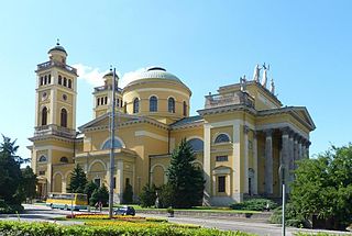
The Archdiocese of Eger is an archdiocese in Northern Hungary, its centre is the city of Eger.

The European route E 22 is one of the longest European routes. It has a length of about 5,320 km (3,310 mi). Many of the E-roads have been extended into Asia since the year 2000; the E 22 was extended on 24 June 2002.
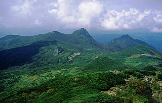
Yūbari Mountains is a mountain range of Hokkaidō, Japan.
Sierra de Fuentes is a municipality located in the province of Cáceres, Extremadura, Spain. According to the 2005 census (INE), the municipality has a population of 2358 inhabitants. Local attractions include beekeeping and wildlife rescue centres.

Hartington railway station opened in 1899 about two miles away from the village it served - Hartington in Derbyshire, south east of Buxton.
Zamłynie is a village in the administrative district of Gmina Skała, within Kraków County, Lesser Poland Voivodeship, in southern Poland.
Stadnica is a village in the administrative district of Gmina Banie Mazurskie, within Gołdap County, Warmian-Masurian Voivodeship, in northern Poland, close to the border with the Kaliningrad Oblast of Russia.

Armena is a hamlet in Alberta, Canada within Camrose County. It is located approximately 21 kilometres (13 mi) northwest of Camrose along Highway 21 and has an elevation of 745 metres (2,444 ft).

Cascavel is a municipality in the state of Ceará in the Northeast region of Brazil.
Palmeira do Piauí is a municipality in the state of Piauí in the Northeast region of Brazil.

Lakshminarayanan Mahadevan FRS is a scientist of Indian origin, and is currently the Lola England de Valpine Professor of Applied Mathematics, Organismic and Evolutionary Biology and Physics at Harvard University. His work centers around understanding the organization of matter in space and time, i.e. how it is shaped and how it flows, particularly at the scale observable by the unaided senses, in both physical and biological systems.
Kozalan is a village in the District of Beypazarı, Ankara Province, Turkey.
Furano-Ashibetsu Prefectural Natural Park is a Prefectural Natural Park in central Hokkaidō, Japan. Established as a Prefectural Park in 1955 and redesignated a Prefectural Natural Park in 1958, the park spans the municipalities of Ashibetsu, Furano, Mikasa, Minamifurano, and Yūbari.
Fındıcak is a village in the District of Mudurnu, Bolu Province, Turkey. As of 2010 it had a population of 125 people.
Kamenichka Skakavitsa is a village in Kyustendil Municipality, Kyustendil Province, south-western Bulgaria.
Hraki is a Syrian village located in Maarrat al-Nu'man Nahiyah in Maarrat al-Nu'man District, Idlib. According to the Syria Central Bureau of Statistics (CBS), Hraki had a population of 1467 in the 2004 census.
Shaturiyeh is a Syrian village located in Bidama Nahiyah in Jisr al-Shughur District, Idlib. According to the Syria Central Bureau of Statistics (CBS), Shaturiyeh had a population of 739 in the 2004 census.

German submarine U-2358 was a Type XXIII U-boat of Nazi Germany's Kriegsmarine during World War II. She was ordered on 20 September 1944, and was laid down on 1 November 1944 at Deutsche Werft AG, Hamburg, as yard number 512. She was launched on 22 December 1944 and commissioned under the command of Oberleutnant zur See Gerhard Breun on 16 January 1945.
6174 is known as Kaprekar's constant after the Indian mathematician D. R. Kaprekar. This number is notable for the following rule:
- Take any four-digit number, using at least two different digits.
- Arrange the digits in descending and then in ascending order to get two four-digit numbers, adding leading zeros if necessary.
- Subtract the smaller number from the bigger number.
- Go back to step 2 and repeat.

Cheng San Public Library is a public library in Hougang, located inside Hougang Mall. It is the third library of the National Library Board to be located in a mall and the first to acquire and display works by local artists. It is near Hougang MRT Station.


