The Gundu Island is one of the many islands that make up the city of Kochi, Kerala, India. The November 1967 amalgamation order of the Kerala Legislative Assembly declared Gundu Island as part of Kochi. Gundu is the smallest island around Kochi with an area of 5 acres (20,000 m2) completely surrounded by coconut trees. The island can be reached from Vypin island only by boat.

Kudma is a river in Nizhny Novgorod Oblast of Russia, a right tributary of the Volga. The river is 144 km long, and drains 2200 square kilometers in the southern suburbs of Nizhny Novgorod.

Aïn Makhlouf is a district in Guelma Province, Algeria. It was named after its capital, Aïn Makhlouf.
Różana is a village in the administrative district of Gmina Udanin, within Środa Śląska County, Lower Silesian Voivodeship, in south-western Poland. Prior to 1945 it was in Germany.
Clapham High School is public, English speaking High School located in Queenswood, Pretoria, in the Gauteng province of South Africa. The school once moved out of central Pretoria to the present facilities in Queenswood, beginning of 1955, and has around 1300 pupils.
Chromium(IV) chloride (CrCl4) is an unstable chromium compound. It is generated by combining chromium(III) chloride and chlorine gas at elevated temperatures, but reverts back to those substances at room temperature.
Huamancaca Chico District is one of nine districts of the province Chupaca in Peru.
Podwólczanka is a village in the administrative district of Gmina Bakałarzewo, within Suwałki County, Podlaskie Voivodeship, in north-eastern Poland.
Czajewszczyzna is a village in the administrative district of Gmina Jeleniewo, within Suwałki County, Podlaskie Voivodeship, in north-eastern Poland.
Konopki-Jabłoń is a village in the administrative district of Gmina Zambrów, within Zambrów County, Podlaskie Voivodeship, in north-eastern Poland.
Trzciniec is a village in the administrative district of Gmina Leszno, within Warsaw West County, Masovian Voivodeship, in east-central Poland.
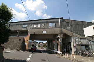
Nishi-Toride Station is a train station in Toride, Ibaraki Prefecture, Japan.
Kłodzino is a village in the administrative district of Gmina Barwice, within Szczecinek County, West Pomeranian Voivodeship, in north-western Poland.

Mayor Square is in Dublin, in the Docklands area. Since December 2009 it is served by the Luas Red Line tram which runs from Tallaght to Connolly and the (C1) extension line from Busáras to The Point. Dublin Bus serves Mayor Street using the 93, bus service. The Red Line extension opened on 9 December 2009.

Passos Maia is a municipality in the state of Santa Catarina in the South region of Brazil.
Rabina is a village in the municipality of Nevesinje, Republika Srpska, Bosnia and Herzegovina.
Mount Shëndelli is a mountain in southern Albania in the geographical region of Southern Albanian Highlands. It is part of the mountain chain Shëndelli-Lunxhëri-Bureto chain, which goes parallel to the Trebeshinë-Dhembel-Nemërçkë chain. Its highest elevation is 1,802 m. Its orientation is north to south. The valley of the river Vjosë, with the city Tepelenë, lies to its south and west.
Gündoğan, Polatlı is a village in the District of Polatlı, Ankara Province, Turkey.
Kafrehmul is a Syrian village located in Maarrat Misrin Nahiyah in Idlib District, Idlib. According to the Syria Central Bureau of Statistics (CBS), Kafrehmul had a population of 3179 in the 2004 census.
St Stephen's Church, Little Ilford is the Roman Catholic parish church for Little Ilford and Manor Park, two areas in Newham, east London. It was first built in 1924 as a chapel to St Nicholas', Manor Park. St Stephen's was rebuilt in 1959 and became the parish church, with St Nicholas' as its chapel, the status both churches still hold today.


