
The Great Dividing Range, also known as the East Australian Cordillera or the Eastern Highlands, is a cordillera system in eastern Australia consisting of an expansive collection of mountain ranges, plateaus and rolling hills, that runs roughly parallel to the east coast of Australia and forms the fifth-longest land-based mountain chain in the world, and the longest entirely within a single country. It is mainland Australia's most substantial topographic feature and serves as the definitive watershed for the river systems in eastern Australia, hence the name.

Scone is a town in the Upper Hunter Shire in the Hunter Region of New South Wales, Australia. At the 2006 census, Scone had a population of 5,624 people. It is on the New England Highway north of Muswellbrook about 270 kilometres north of Sydney, and is part of the New England (federal) and Upper Hunter (state) electorates. Scone is in a farming area and is also noted for breeding Thoroughbred racehorses. It is known as the 'Horse capital of Australia'.

Liverpool Plains Shire is a local government area located in the North West Slopes region of New South Wales, Australia. The Shire was formed on 17 March 2004 by the amalgamation of Quirindi Shire with parts of Parry, Murrurundi and Gunnedah shires.

The Liverpool Range is a mountain range and a lava-field province in New South Wales, Australia.

The Brindabella Range, commonly called The Brindabellas or The Brindies, is a mountain range located in Australia, on a state and territory border of New South Wales and the Australian Capital Territory (ACT). The range rises to the west of Canberra, the capital city of Australia, and includes the Namadgi National Park in the ACT and the Bimberi Nature Reserve and Brindabella National Park in New South Wales. The Brindabellas are visible to the west of Canberra and form an important part of the city's landscape.
Murrurundi( MURR-oo-RUN-dye), is a rural town located in the Upper Hunter Shire, in the Upper Hunter region of New South Wales, Australia.
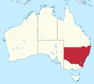
New South Wales is Australia's most populous state, located in the east coast of the continent. It is in the southern hemisphere between latitudes 28 and 38 degrees south of the equator and longitudes 143 and 154 degrees east of the Universal Prime Meridian. The state is in the warm temperate climatic zone.

The Illawarra escarpment, or officially the Illawarra Range, is the fold-created cliffs and plateau-eroded outcrop mountain range west of the Illawarra coastal plain south of Sydney, in the state of New South Wales, Australia. The range encloses the Illawarra region which stretches from Stanwell Park in the north to Kiama, Gerringong and the Shoalhaven River in the south.

Merriwa is a town located in the Upper Hunter Shire, in the far west of the Hunter region of New South Wales, Australia.

The Liverpool Plains are an extensive agricultural area covering about 12,000 km2 (4,600 sq mi) of the north-western slopes of New South Wales in Australia.

The Ardglen Tunnel, also called the Liverpool Range tunnel, is a heritage-listed summit rail tunnel located on the Main North railway between Ardglen in the Liverpool Plains Shire and Murrurundi in the Upper Hunter Shire local government area, both in New South Wales, Australia. The tunnel crosses under the Liverpool Range near its east end, below Nowlands Gap, the crossing used by the New England Highway, and provides a vital link between Newcastle and Werris Creek. The tunnel was completed in 1877 and is owned by the Transport Asset Holding Entity, a state-owned corporation of the Government of New South Wales. It was added to the New South Wales State Heritage Register on 2 April 1999.

Mount Ginini is a mountain with an elevation of 1,762 metres (5,781 ft) AHD in the Brindabella Ranges that is located on the border between the Australian Capital Territory and New South Wales in Australia.
Mount Boyce is a hill standing approximately 1,093 metres (3,586 ft) AMSL, situated as one of the highest points on a plateau within the Explorer Range, part of the Blue Mountains Range which is a spur off the Great Dividing Range. Mount Boyce is located 2 kilometres (1.2 mi) north of Blackheath, in New South Wales, Australia.
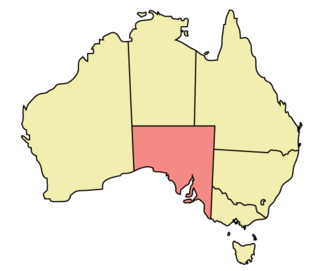
The geography of South Australia incorporates the south central part of the continent of Australia. It is one of the six states of Australia. South Australia is bordered on the west by Western Australia, to the north by the Northern Territory, Queensland to the northeast, and both New South Wales and Victoria to the east. South Australia's south coast is flanked by the Great Australian Bight and the Southern Ocean.

The Mount Royal Range is a mountain range in the Hunter region of New South Wales, Australia.
Isis River, a perennial river of the Hunter River catchment, is located in the Upper Hunter region of New South Wales, Australia.
The Nowlands Creek, a watercourse of the Clarence River catchment, is located in the Northern Tablelands region in the state of New South Wales, Australia.

Pages River, a perennial river of the Hunter River catchment, is located in the Hunter region of New South Wales, Australia.
Melville is a locality in the City of Maitland in the Hunter Region of New South Wales, Australia.
