
Wolica is a village in the administrative district of Gmina Hrubieszów, within Hrubieszów County, Lublin Voivodeship, in eastern Poland, close to the border with Ukraine. It lies approximately 4 kilometres (2 mi) south-west of Hrubieszów and 104 km (65 mi) south-east of the regional capital Lublin.
Brodzica is a village in the administrative district of Gmina Hrubieszów, within Hrubieszów County, Lublin Voivodeship, in eastern Poland, close to the border with Ukraine. It lies approximately 4 kilometres (2 mi) south-west of Hrubieszów and 103 km (64 mi) south-east of the regional capital Lublin.
Cichobórz is a village in the administrative district of Gmina Hrubieszów, within Hrubieszów County, Lublin Voivodeship, in eastern Poland, close to the border with Ukraine. It lies approximately 13 kilometres (8 mi) south-east of Hrubieszów and 115 km (71 mi) south-east of the regional capital Lublin.
Czerniczyn is a village in the administrative district of Gmina Hrubieszów, within Hrubieszów County, Lublin Voivodeship, in eastern Poland, close to the border with Ukraine. It lies approximately 7 kilometres (4 mi) south of Hrubieszów and 109 km (68 mi) south-east of the regional capital Lublin.
Czortowice is a village in the administrative district of Gmina Hrubieszów, within Hrubieszów County, Lublin Voivodeship, in eastern Poland, close to the border with Ukraine. It lies approximately 6 kilometres (4 mi) north of Hrubieszów and 101 km (63 mi) south-east of the regional capital Lublin.
Dąbrowa is a village in the administrative district of Gmina Hrubieszów, within Hrubieszów County, Lublin Voivodeship, in eastern Poland, close to the border with Ukraine. It lies approximately 4 kilometres (2 mi) north-east of Hrubieszów and 105 km (65 mi) south-east of the regional capital Lublin.
Dziekanów is a village in the administrative district of Gmina Hrubieszów, within Hrubieszów County, Lublin Voivodeship, in eastern Poland, close to the border with Ukraine. It lies approximately 6 kilometres (4 mi) north of Hrubieszów and 101 km (63 mi) south-east of the regional capital Lublin.
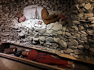
Gródek is a village in the administrative district of Gmina Hrubieszów, within Hrubieszów County, Lublin Voivodeship, in eastern Poland, close to the border with Ukraine. It lies approximately 5 kilometres (3 mi) east of Hrubieszów and 109 km (68 mi) south-east of the regional capital Lublin. Important archeological site.
Husynne is a village in the administrative district of Gmina Hrubieszów, within Hrubieszów County, Lublin Voivodeship, in eastern Poland, close to the border with Ukraine. It lies approximately 8 kilometres (5 mi) east of Hrubieszów and 109 km (68 mi) south-east of the regional capital Lublin.
Kobło is a village in the administrative district of Gmina Hrubieszów, within Hrubieszów County, Lublin Voivodeship, in eastern Poland, close to the border with Ukraine. It lies approximately 9 kilometres (6 mi) north-east of Hrubieszów and 107 km (66 mi) south-east of the regional capital Lublin.
Kułakowice Trzecie is a village in the administrative district of Gmina Hrubieszów, within Hrubieszów County, Lublin Voivodeship, in eastern Poland, close to the border with Ukraine. It lies approximately 13 kilometres (8 mi) north-west of Hrubieszów and 94 km (58 mi) south-east of the regional capital Lublin.
Masłomęcz is a village in the administrative district of Gmina Hrubieszów, within Hrubieszów County, Lublin Voivodeship, in eastern Poland, close to the border with Ukraine. It lies approximately 11 kilometres (7 mi) south of Hrubieszów and 110 km (68 mi) south-east of the regional capital Lublin.
Metelin is a village in the administrative district of Gmina Hrubieszów, within Hrubieszów County, Lublin Voivodeship, in eastern Poland, close to the border with Ukraine. It lies approximately 9 kilometres (6 mi) south of Hrubieszów and 106 km (66 mi) south-east of the regional capital Lublin.
Moniatycze is a village in the administrative district of Gmina Hrubieszów, within Hrubieszów County, Lublin Voivodeship, in eastern Poland, close to the border with Ukraine. It lies approximately 6 kilometres (4 mi) north of Hrubieszów and 100 km (62 mi) south-east of the regional capital Lublin.
Obrowiec is a village in the administrative district of Gmina Hrubieszów, within Hrubieszów County, Lublin Voivodeship, in eastern Poland, close to the border with Ukraine. It lies approximately 4 kilometres (2 mi) west of Hrubieszów and 101 km (63 mi) south-east of the regional capital Lublin.
Stefankowice is a village in the administrative district of Gmina Hrubieszów, within Hrubieszów County, Lublin Voivodeship, in eastern Poland, close to the border with Ukraine. It lies approximately 11 kilometres (7 mi) north of Hrubieszów and 98 km (61 mi) south-east of the regional capital Lublin.
Stefankowice-Kolonia is a village in the administrative district of Gmina Hrubieszów, within Hrubieszów County, Lublin Voivodeship, in eastern Poland, close to the border with Ukraine. It lies approximately 12 kilometres (7 mi) north of Hrubieszów and 96 km (60 mi) south-east of the regional capital Lublin.
Świerszczów is a village in the administrative district of Gmina Hrubieszów, within Hrubieszów County, Lublin Voivodeship, in eastern Poland, close to the border with Ukraine. It lies approximately 2 kilometres (1 mi) east of Hrubieszów and 105 km (65 mi) south-east of the regional capital Lublin.
Ubrodowice is a village in the administrative district of Gmina Hrubieszów, within Hrubieszów County, Lublin Voivodeship, in eastern Poland, close to the border with Ukraine. It lies approximately 11 kilometres (7 mi) north of Hrubieszów and 99 km (62 mi) south-east of the regional capital Lublin.
Wołajowice is a village in the administrative district of Gmina Hrubieszów, within Hrubieszów County, Lublin Voivodeship, in eastern Poland, close to the border with Ukraine. It lies approximately 7 kilometres (4 mi) north of Hrubieszów and 102 km (63 mi) south-east of the regional capital Lublin.


