Hollands Diep is a wide river in the Netherlands and an estuary of the Rhine and Meuse river. Through the Scheldt-Rhine Canal it connects to the Scheldt river and Antwerp.

Bareilly division is an administrative geographical unit of Uttar Pradesh state of India. Bareilly is the administrative headquarters of the division. Bareilly division has three major cities in west Uttar Pradesh - Bareilly, Badaun, Pilibhit and Shahjahanpur.
Tring Rural is a civil parish in Hertfordshire, England. It is composed of the villages of Long Marston, Wilstone, Puttenham, and the hamlets of Gubblecote and Astrope. It is largely situated the north of the Kingdom of Tring. The Kingdom of Tring itself is not part of the parish.
Babine Lake Marine Provincial Park is a provincial park in British Columbia, Canada. The park was established by Order-in-Council in 1993, comprising two sites at Pendleton Bay totalling 36.9 hectares. Another was established in the same year at Smithers Landing, comprising approximately 157.8 hectares. Three more sites were added in 2001, Hook (Deep) Bay, Pierre Creek, Pinkut Creek and Sandpoint. All sites combined comprise approximately 492 hectares.

Regenboogstadion is a stadium in Waregem, Belgium. It is currently used mostly for football matches and is the home ground of S.V. Zulte-Waregem. Regenboogstadion is Dutch for Rainbow Stadium. The stadium was named after the rainbow jersey worn by the cycling road world champions, since it was inaugurated to host the 1957 UCI Road World Championships.

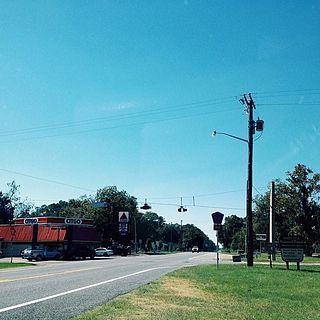
Olustee is an unincorporated community in Baker County, Florida, United States. The name "Olustee" is from the nearby Olustee Creek whose name derives from the Creek (Muscogee) language ue-lvste (/oy-lást-i/) meaning "black water". The town was historically known as Olustee Station and is the location of the Olustee Battlefield Historic State Park and of the ranger station for the Osceola National Forest, which is headquartered there. The US Forest Service has restored the former railroad depot at the center of town as a visitor center and museum for forest visitors.

Meridian International School, established in 2001, is an international day school in Kiev, Ukraine, catering for children from pre-school to the 11th grade.
Kwikwasut'inuxw Haxwa'mis, formerly the Kwicksutaineuk-ah-kwa-mish First Nation is a First Nations band government based on northern Vancouver Island in British Columbia, Canada, in the Queen Charlotte Strait region. It is a member of the Musgamagw Tsawataineuk Tribal Council, along with the ‘Namgis First Nation and the Tsawataineuk First Nation. The Kwikwasut'inuxw and Haxwa'mis are two of the many subgroups of the peoples known as Kwakwaka'wakw, which means "speakers of Kwak'wala", their language, and were combined into one band by the Department of Indian and Northern Affairs.

Motyl is a village in the administrative district of Gmina Gostycyn, within Tuchola County, Kuyavian-Pomeranian Voivodeship, in north-central Poland. It lies approximately 7 kilometres (4 mi) south of Gostycyn, 20 km (12 mi) south of Tuchola, and 37 km (23 mi) north of Bydgoszcz.
Depułtycze Królewskie-Kolonia is a village in the administrative district of Gmina Chełm, within Chełm County, Lublin Voivodeship, in eastern Poland.
Maciejkowa Góra is a village in the administrative district of Gmina Michałowo, within Białystok County, Podlaskie Voivodeship, in north-eastern Poland, close to the border with Belarus.

Zamanlı is a village in the Gadabay Rayon of Azerbaijan. The village forms part of the municipality of Mormor.

Karczówek is a village in the administrative district of Gmina Szadek, within Zduńska Wola County, Łódź Voivodeship, in central Poland. It lies approximately 3 kilometres (2 mi) west of Szadek, 12 km (7 mi) north of Zduńska Wola, and 37 km (23 mi) west of the regional capital Łódź.

Wszechświęte is a village in the administrative district of Gmina Sadowie, within Opatów County, Świętokrzyskie Voivodeship, in south-central Poland. It lies approximately 5 kilometres (3 mi) east of Sadowie, 7 km (4 mi) north of Opatów, and 58 km (36 mi) east of the regional capital Kielce.
Bałki is a village in the administrative district of Gmina Repki, within Sokołów County, Masovian Voivodeship, in east-central Poland.

Ruszkowo-Parcel is a village in the administrative district of Gmina Wierzbinek, within Konin County, Greater Poland Voivodeship, in west-central Poland. It lies approximately 7 kilometres (4 mi) west of Wierzbinek, 26 km (16 mi) north-east of Konin, and 103 km (64 mi) east of the regional capital Poznań.

Cychry is a village in the administrative district of Gmina Dębno, within Myślibórz County, West Pomeranian Voivodeship, in north-western Poland. It lies approximately 6 kilometres (4 mi) south of Dębno, 30 km (19 mi) south of Myślibórz, and 82 km (51 mi) south of the regional capital Szczecin.

Schafberg is a mountain of Saxony, in southeastern Germany.


