
Andrew Geddes Bain, was a South African geologist, road engineer, palaeontologist and explorer.

The Vaal Dam in South Africa was constructed in 1938 and lies 77 km south of OR Tambo International Airport, Johannesburg. The lake behind the dam wall has a surface area of about 320 square kilometres (120 sq mi) and is 47 meters deep. The Vaal Dam lies on the Vaal River, which is one of South Africa's strongest-flowing rivers. Other rivers flowing into the dam are the Wilge River, Klip River, Molspruit and Grootspruit. It has over 800 kilometres (500 mi) of shoreline and is South Africa's second biggest dam by area and the fourth largest by volume.
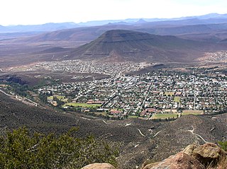
Graaff-Reinet is a town in the Eastern Cape Province of South Africa. It is the oldest town in the province. It is also the sixth-oldest town in South Africa, after Cape Town, Stellenbosch, Simon's Town, Paarl and Swellendam. The town was the centre of a short-lived republic in the late 18th century. The town was a starting point for Great Trek groups led by Gerrit Maritz and Piet Retief and furnished large numbers of the Voortrekkers in 1835–1842.

The R63 is a tarred provincial route in South Africa that connects Calvinia with Komga via Carnarvon, Victoria West, Graaff-Reinet, Somerset East and King William's Town. It is cosigned with the N10 between Eastpoort and Cookhouse for 24 kilometres.

Laingsburg is a town located in the Western Cape province in South Africa. It is a relatively large agricultural town in the semi-arid Great Karoo. It was partially destroyed in a flash flood in 1981.

Hartbeespoort Dam is an arch type dam situated in the North West Province of South Africa. It lies in a valley to the south of the Magaliesberg mountain range and north of the Witwatersberg mountain range, about 35 kilometres north west of Johannesburg and 20 kilometres west of Pretoria. The name of the dam means "dam at the gorge of the hartebeest" in Afrikaans. This "poort" in the Magaliesberg was a popular spot for hunters, where they cornered and shot the hartebeest. The dam was originally designed for irrigation, which is currently its primary use, as well as for domestic and industrial use. The dam has suffered from a hypertrophic state since the early 1970s. Mismanagement of waste water treatment from urban zones within the Hartbeespoort Dam catchment area is largely to blame, having distorted the food web with over 280 tons of phosphate and nitrate deposits.
Jacobus Nicolaas Boshof was a South African (Boer) statesman, a late-arriving member of the Voortrekker movement, and the second state president of the Orange Free State, in office from 1855 to 1859.
The !Khukaǁgamma or Sundaysriver is a river in the Eastern Cape Province of South Africa. It is said to be the fastest flowing river in the country. The Inqua Khoi people, who historically were the wealthiest group in Southern Africa, originally named this river !Khukaǁgamma because the river's banks are always green and grassy despite the arid terrain that it runs through.
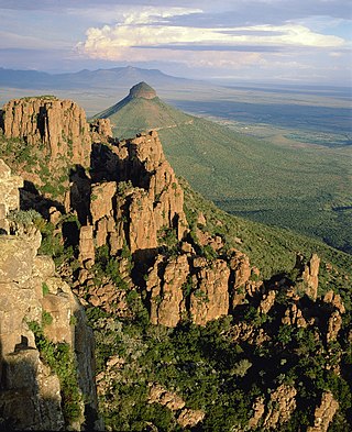
The Camdeboo National Park is located in the Karoo and almost completely surrounds the Eastern Cape town of Graaff-Reinet. It contains the Nqweba Dam.

The N9 is a national route in South Africa that connects George with the N1 at Colesberg, via Graaff-Reinet and Middelburg.

The Berg River Dam is a 68-metre (223 ft) high dam on the Berg River in South Africa. It is the centerpiece of the Berg Water Project (BWP) which is designed to capture the winter rainfall and store it for supply to Cape Town during the dry summer months. The project in turn forms an important part of the Western Cape Water Supply System (WCWSS), an intricate system of dams and bulk water infrastructure that provides water to more than 3 million people. At the inauguration of the dam in 2009, then President of South Africa Kgalema Motlanthe called the project "a good example of how public infrastructure projects can be used to contribute meaningfully to poverty eradication and to foster social empowerment of the people." The Berg River Dam was the first dam in South Africa to be designed and constructed, and is due to be operated, in accordance with the guidelines of the World Commission on Dams. It has been completed on time and within budget. The Berg River basin and the adjacent metropolitan area of Cape Town are of particular importance to the Western Cape region because, although the basin generates only about 3% of the country's water resources, it is home to about 8% of South Africa's population, and produces about 12% of GDP.
Theewaterskloof Dam is an earth-fill type dam located on the Sonderend River near Villiersdorp, Western Cape, South Africa. Administratively it is located within Theewaterskloof Local Municipality. It was established in 1978 and is the largest dam in the Western Cape Water Supply System with a capacity of 480 million cubic metres, about 41% of the water storage capacity available to Cape Town, which has a population of over 4 million people. The dam mainly serves for municipal and industrial use as well as for irrigation purposes. The hazard potential of the dam has been ranked high (3).
Voëlvlei Dam is a dam located in the Western Cape, South Africa near the town of Gouda. The earth-fill wall is 2,910 metres (9,550 ft) long and 10 metres (33 ft) high. The reservoir covers an area of 1,524 hectares and has a capacity of 168,000 megalitres, making it the second-largest reservoir in the Western Cape Water Supply System. Water from the reservoir is supplied to water treatment works of the City of Cape Town and the West Coast District Municipality, and can also be released into the Berg River for agricultural purposes or to fill the Misverstand Dam.

Wemmershoek Dam is a rock-fill type dam located on the Wemmershoek River near Franschhoek and Paarl in South Africa. It was constructed between 1953 and 1957 on behalf of the City of Cape Town. With a reservoir capacity of 58,644 megalitres, it provides approximately 6.5% of the storage capacity of the Western Cape Water Supply System which supplies Cape Town and surrounding areas.
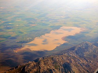
De Hoop Dam is a dam on the Kamdeboo River, near Graaff-Reinet, Eastern Cape, South Africa. It was established in 1938 and its primary purpose is for irrigation.
Pearston is a small town in the eastern Karoo, in the Eastern Cape province of South Africa. It lies between Graaff-Reinet and Somerset East at the foot of the Coetzeesberge, about 160 kilometres (100 mi) north of Port Elizabeth. It falls within the Blue Crane Route Local Municipality and has a population of approximately 4,500 people.
Graaff-Reinet Municipality v Van Ryneveld's Pass Irrigation Board is an important case in South African law. It was heard in the Appellate Division on March 6, 1950, with judgment handed down on March 21. The judges were Watermeyer CJ, Centlivres JA, Schreiner JA, Van Den Heever JA, and Murray AJA. The case was an appeal from a decision in the Cape Provincial Division by Steyn J and Searle J. The appellant's attorneys were Herold, Gie & Broadhead, Cape Town, and McIntyre & Watkeys, Bloemfontein. The respondent's attorneys were Mostert & Bosman, Cape Town, and Reitz, Barry & Berning, Bloemfontein.

Graaff-Reinet Commando was a light infantry regiment of the South African Army. It formed part of the South African Army Infantry Formation as well as the South African Territorial Reserve.
The Eastern Cape region of South Africa experienced a severe multi-year drought from 2015 through early 2020. The drought was one of the worst in the region's history and led the South African government to declare the region a "disaster area" in October 2019.
Samantha Jane Graham is a South African politician from the Eastern Cape who was elected to the National Assembly of South Africa in the 2019 general election as a member of the Democratic Alliance. Graham has been the party's Shadow Minister of Electricity since 2023. Graham served as the shadow deputy minister of public works and infrastructure from 2019 to 2020 and as the shadow minister for the portfolio between 2020 and 2023. She is a former councillor of the Dr Beyers Naudé Local Municipality.


