Honduras is a country in Central America. Honduras borders the Caribbean Sea and the North Pacific Ocean. Guatemala lies to the west, Nicaragua south east and El Salvador to the south west. Honduras is the second largest Central American republic, with a total area of 112,890 square kilometres (43,590 sq mi).

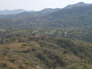
Ocotepeque is one of the 18 departments of Honduras, Central America, located in the West and bordering both El Salvador and Guatemala. It was formed in 1906 from part of Copán department. The capital and main city is Nueva Ocotepeque.

Cololaca is a municipality in the Honduran department of Lempira.

Guarita is a municipality in the Honduran department of Lempira.

La Virtud is a municipality in the Honduran department of Lempira.

Mapulaca is a municipality in the Honduran department of Lempira.

Ocotepeque is a municipality in the Honduran department of Ocotepeque. The town of Nueva Ocotepeque is the municipal seat and the capital of the department.
San Marcos is a town, with a population of 6,836, and a municipality in the Honduran department of Ocotepeque.

Santa Fe is a municipality in the Honduran department of Ocotepeque. As of 2015, its population was of 5,006.
Sinuapa is a municipality in the Honduran department of Ocotepeque.

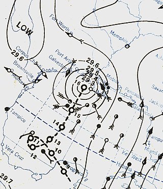
The 1934 Central America hurricane was a tropical cyclone that caused at least 506 fatalities in Central America in June 1934, making it one of the deadliest hurricanes in Atlantic history. Its peak strength in the Gulf of Mexico was equivalent to a Category 2 hurricane on the modern Saffir–Simpson scale. The storm's path was erratic, beginning in the Gulf of Honduras on June 4 shortly before making its first landfall on the British Honduras as a tropical storm. It then took a looping course through Guatemala before reemerging into the Gulf of Honduras on June 8. The storm struck the northeastern Yucatán Peninsula as a hurricane on June 9, crossing into the western Gulf of Mexico where its course made another loop. An accelerated northward course followed, leading to the hurricane's landfall along the Louisiana coast on June 16. It weakened over land and transitioned into an extratropical cyclone on June 18, accelerating northeast towards the Canadian Maritimes thereafter.
The Chʼortiʼ people are one of the indigenous Maya peoples, who primarily reside in communities and towns of southeastern Guatemala, northwestern Honduras, and northern El Salvador. Their indigenous language, also known as Chʼortiʼ, is a survival of Classic Choltian, the language of the inscriptions in Copan. It is the first language of approximately 15,000 people, although the majority of present-day Chʼortiʼ speakers are bilingual in Spanish as well.

Nueva Esparta is a municipality in the northeasternmost zone of El Salvador, inside La Unión Department. The municipality is politically divided into the central Pueblo Nueva Esparta, six outlying canton communities and 31 caserios.

The Lempa River is a 422-kilometre-long (262 mi) river in Central America.
La Quebradona is a river located in Ocotepeque Department, Honduras.

The Honduras–Nicaragua border is the roughly 950-kilometre-long (590 mi) international boundary between Honduras and Nicaragua, running from the Gulf of Fonseca on the Pacific Ocean to the Caribbean Sea. The Coco River, which flows generally northeast to the Caribbean, forms more than half of the border.

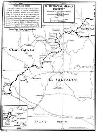
The El Salvador–Guatemala border is a 203 km (126 mi) international boundary in the northeast–southwest direction, northwest of El Salvador, and separating the country from the territory of Guatemala. From north to south, it starts in the triple border of the two countries with Honduras, near the peak Monte Cristo in Volcanoes National Park, extending to the southwest by the Pacific Ocean coast, following the final stage the Rio Paz. It separates the department of Jutiapa in Guatemala from Ahuachapan (north) and Santa Ana departments in El Salvador. It runs along 105 mi (169 km) of rivers, 19 mi (31 km) of straight-line segments and 2 mi (3.2 km) in Lake Güija. 530 boundary pillars were erected in 1940.
Nueva Ocotepeque Airport is an airport serving the town of Nueva Ocotepeque in Ocotepeque Department, Honduras. Nueva Ocotepeque is in a north-south valley 5 kilometres (3.1 mi) north of the El Salvador border, and 13 kilometres (8.1 mi) east of the Guatemala border.
The network of highways in Honduras is managed by the Secretariat of public works, transport and housing (SOPTRAVI), through the General Directorate of Roads, which is responsible for planning construction and maintenance work on the country's roads. Honduras has more than 15,400 kilometres (9,600 mi) of roads. Up to 1999, only 3,126 kilometres (1,942 mi) had been paved.
This page is based on this
Wikipedia article Text is available under the
CC BY-SA 4.0 license; additional terms may apply.
Images, videos and audio are available under their respective licenses.


