
Kathmandu, officially the Kathmandu Metropolitan City, is the seat of federal government and the most populous city in Nepal. As of the 2021 Nepal census, there were 845,767 inhabitants living in 105,649 households and approximately 4 million people in its surrounding agglomeration. It is located in the Kathmandu Valley, a large valley surrounded by hills in central Nepal, at an altitude of 4,344 feet above sea level.

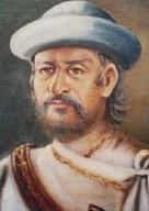
Prithvi Narayan Shah, was the last king of the Gorkha Kingdom and first king of the Kingdom of Nepal. Prithvi Narayan Shah started the unification of Nepal. He is also credited for moving the royal seat of power to Kathmandu.
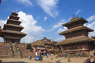
Bhaktapur, known locally as Khwopa and historically called Bhadgaon, is a city in the east corner of the Kathmandu Valley in Nepal located about 13 kilometres (8.1 mi) from the capital city, Kathmandu. Bhaktapur is the smallest city of Nepal as well as the most densely populated. Along with Kathmandu and Lalitpur, Bhaktapur is one of the three main cities of the Kathmandu Valley and is a major Newar settlement of the country. The city is also known for its Newar tradition, cuisine and artisans. Bhaktapur suffered heavy damage in the April 2015 earthquake.

The Kathmandu Valley, also known as the Nepal Valley or Nepa Valley, National Capital Area, is a bowl-shaped valley located in the Himalayan mountains of Nepal. It lies at the crossroads of ancient civilizations of the Indian subcontinent and the broader Asian continent, and has at least 130 important monuments, including several pilgrimage sites for Hindus and Buddhists. The valley holds seven World Heritage Sites within it.

The unification of Nepal was the process of building the modern Nepalese state, from fractured petty kingdoms including the Baise Rajya and the Chaubisi Rajya, which began in 1743 AD. The prominent figure in the unification campaign was Prithvi Narayan Shah, King of Gorkha. On 25 September 1768, he officially announced the creation of the Kingdom of Nepal and moved his capital from Gorkha to the city of Kathmandu.
Nuwakot District, a part of Bagmati Province, is one of the seventy-seven districts of Nepal. The district, with Bidur as its district headquarters, covers an area of 1,121 km2 (433 sq mi) and had a population of 288,478 in 2001 and 277,471 in 2011.

The Malla dynasty also known as the Malla confederacy, was the ruling dynasty of the Kathmandu Valley in Nepal from 1201 to 1779. This dynasty was founded by Arideva Malla. Though the latter Mallas were regarded as belonging to the Raghuvamsha dynasty, they were also seen as continuations and descendants of the Licchavi dynasty. Later Malla kings also traced one section of their lineage from Nanyadeva, the founder of the Karnat dynasty of Mithila. The term malla means wrestler in Sanskrit. The first use of the word malla in the Kathmandu Valley began in 1201.

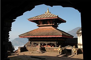
Newar architecture or Newa architecture is an indigenous style of architecture used by the Newari people in the Kathmandu valley in Nepal. Newar architecture consists of the pagoda, stupa, shikhara, chaitya and other styles. It is also known for its exquisite craftsmanship. Unique city planning and the harmonious integration of art, religion, and daily life. This architectural style is closely related to the cultural and historical development of Kathmandu Valley and has greatly influenced the architectural traditions of the region. The valley's trademark is the multiple-roofed Pagoda which may have originated in this area and spread to India, China, Indochina and Japan. Residential houses, monastic courtyards known as baha and bahi, rest houses, temples, stupas, priest houses and palaces are the various architectural structures found in the Kathmandu valley. Most of the chief monuments are located in the Durbar Squares of Kathmandu, Lalitpur and Bhaktapur, the old royal palace complexes built between the 12th and 18th centuries. The style is marked by striking brick work and a unique style of wood carving rarely seen outside Nepal. The style has been propagated by Nepalese architects including Arniko.

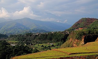
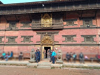
Nuwakot is a town in central Nepal, serving as the namesake of the district of the same name. The town is located on the bank of Trishuli and Tandi Rivers. It is located around 60 kilometres west of Kathmandu, and is known as a historic town which was the capital of the Valley in the days before the unification of Nepal by Prithvi Narayan Shah, and for more than 1,000 years the hilltop had served as a lookout and fort (kot) guarding the western entrance to Kathmandu Valley. Nuwakot served as an important trading hub for the Malla kings of the Valley, and was along a major transit route used for trade between India and Tibet. Making the Nuwakot hill as main forts including other eight forts: Malakot, Simalkot, Bhairabkot, Belkot, Kalikot, Salyankot, Dhuwankot and Pyaskot in its surrounding area, collectively named as 'Nawakotta'.
Basnyat/Basnet family or Basnyat/Basnet dynasty was a Khas-Chhetri and a warlord clan family involved in the politics and administration of the Gorkha Kingdom and Kingdom of Nepal. This family got entry into Thar Ghar aristocracy group of Gorkha at the time of King Prithvi Narayan Shah. It was one of the four noble families to be involved in active politics of Nepal together with the Shah dynasty, Pande family and the Thapa dynasty before the rise of the Rana dynasty. This family is descended from Shivaram Singh Basnyat, the commander of Gorkhali forces and a member of Shreepali Basnyat clan of Gorkha. This family was maritally linked to Kala (Black) Pande section of the Pande dynasty through Chitravati Pande who married Kaji Kehar Singh Basnyat. This family was the last Kshatriya (Chhetri) political family to be wiped out from the central power by Jung Bahadur Rana of Kunwar family during the Bhandarkhal Massacre in 1846 for the conspiracy to take the power leading to people suffering from 104 long years of the Rana rule.
Ranajita Malla was the last king of the Malla dynasty who ruled Bhaktapur from 1722 to 1769. He is widely known for his contribution to Nepal Bhasa literature, in particular his plays are generally praised by modern scholars. He has been generally described as a peace loving, simple and pious monarch who allowed his citizens to advise and criticize him. However, his reign was characterized by constant disputes with Kantipur and Gorkha. He is also known for the crisis of succession during his reign when he favored his concubine's issue over his queen consort's, who was more generally liked, which caused a lot of mutiny in the kingdom especially in cities like Thimi and Banepa.

Hanuman Dhoka is a complex of structures with the Royal Palace of the Malla kings and also of the Shah dynasty in the Durbar Square of central Kathmandu, Nepal.The Hanuman Dhoka Palace gets its name from the stone image of Hanuman, the Hindu deity, that sits near the main entryway. 'Dhoka' means door or gate in Nepali. The buildings were severely damaged in the 2015 earthquake.

Kathmandu Durbar Square is a historically and culturally significant site in Kathmandu, Nepal. It is one of the three Durbar Squares in the Kathmandu Valley in Nepal that are UNESCO World Heritage Sites.

The architectural heritage of Kathmandu city is integral to that of the Kathmandu valley since all monuments have evolved over centuries of craftsmanship influenced by Hindu and Buddhist religious practices. The architectural treasure of the Kathmandu valley has been categorized under the well known seven groups of heritage monuments and buildings. In 2006, UNESCO declared these seven groups of monuments as a World Heritage Site (WHS). The seven monuments zones cover an area of 188.95 hectares, with the buffer zone extending to 239.34 hectares. The Seven Monument Zones (Mzs) inscribed originally in 1979 with a minor modification in inscribed year as 2006, are: Five monuments in Kathmandu – Durbar square of Hanuman Dhoka, Hindu temples of Pashupatinath and Changunarayan, the Buddha stupas of Swayambu and Boudhanath; and two monuments outside Kathmandu city limits, in the satellite towns of Patan and Bhktapur – Durbar square at Patan, Durbar square at Bhaktapur. Brief details of the five Kathmandu city monuments are elaborated here.

The ancient and refined traditional culture of Kathmandu, for that matter in the whole of Nepal, is an uninterrupted and exceptional meeting of the Hindu and Buddhist ethos practiced by its highly religious people. It has also embraced in its fold the cultural diversity provided by the other religions such as Kirat, Jainism, Islam and Christianity.

Bhaktapur Durbar Square is a former royal palace complex located in Bhaktapur, Nepal. It housed the Malla kings of Nepal from 14th to 15th century and the kings of the Kingdom of Bhaktapur from 15th to late 18th century until the kingdom was conquered in 1769. Today, this square is recognised by UNESCO, managed jointly by the Archeological Department of Nepal and Bhaktapur Municipality, and is undergoing extensive restoration due to the damages from the earthquake in 1934 and the recent earthquake of 2015.
Patan Durbar Square is situated at the centre of the city of Lalitpur in Nepal. It is one of the three Durbar Squares in the Kathmandu Valley, all of which are UNESCO World Heritage Sites. One of its attractions is the medieval royal palace where the Malla Kings of Lalitpur resided.

The Battle of Lalitpur in 1768 ended with the Gorkha conquest of Lalitpur, one of the three kingdoms in Nepal centered in the Kathmandu Valley, and the loss of the rule of the native Newars.

The Battle of Nuwakot also called Siege of Nuwakot or Invasion of Nuwakot was fought in Nuwakot in 1744. Nuwakot was controlled by the Kingdom of Kantipur and it was an important location as it had a trade route to Tibet. The Gorkha Kingdom previously attacked twice by Nara Bhupal Shah and his son Prithvi Narayan Shah respectively. To prepare for the war Prithvi Narayan Shah visited Varanasi to get war materials, ammunition, acquire weapons, train the soldiers, and Pilgrims. He improved his army personnel and included people from any caste including the blacksmiths, cobblers, sweepers, Damai, and anyone who was bodied and physically fit was able to join the crew.
Bhairabi Temple is a Hindu temple in Bidur Municipality, Nuwakot, Nepal. It is dedicated to goddess Bhairavi, the consort of god Bhairav. It lies about 200m south from the seven storied palace. This temple is also known by the name of Gandaki bhairavi getting its name from the Trishuli Gandaki River.


