
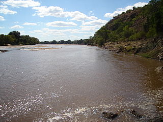
The Olifants River, Lepelle or Obalule is a river in South Africa and Mozambique, a tributary of the Limpopo River. It falls into the Drainage Area B of the Drainage basins of South Africa. The historical area of the Pedi people, Sekhukhuneland, is located between the Olifants River and one of its largest tributaries, the Steelpoort River.

The Mokolo River is a major watercourse in Limpopo Province of South Africa. This river collects much of the drainage of the Waterberg Massif and discharges it to the Limpopo River. The river's catchment area comprises 8,387 square kilometres (3,238 sq mi).
The Mzingwane River, formerly known Umzingwane River as or Umzingwani River is a major left-bank tributary of the Limpopo River in Zimbabwe. It rises near Fort Usher, Matobo District, south of Bulawayo and flows into the Limpopo River near Beitbridge, downstream of the mouth of the Shashe River and upstream of the mouth of the Bubye River.
Nandoni Dam, previously known as the Mutoti Dam, is an earth-fill/concrete type dam in Limpopo province, South Africa. It is located on the Luvuvhu River near the villages of ha-Mutoti and ha-Budeli and ha-Mphego just a few kilometres from Thohoyandou in the district of Vhembe. The dam serves primarily for water supply and its hazard potential has been ranked high (3).
The Sand River or Polokwane River is a watercourse in Limpopo Province, South Africa, a right hand tributary of the Limpopo River. Its new name "Polokwane River" is homonymous with the name of the town of Polokwane, formerly Pietersburg, about 200 kilometres (120 mi) upriver from its mouth. The Sand River flows by the western edge of this town.

Mwenezi River is a major tributary of the Limpopo River. The Mwenezi River starts up in south central Zimbabwe and flows south-east along what is known as the Mwenezi River Valley that bisects the district into two sectors. The river is found in both Zimbabwe and Mozambique. In Zimbabwe it has been known as the Nuanetsi or Nuanetzi River in the past, a name it retains in Mozambique.
Limpopo WMA, or Limpopo Water Management Area(coded: 1), in South Africa includes the following major rivers: the Limpopo River, Matlabas River, Mokolo River, Lephalala River, Mogalakwena River, Sand River and Nzhelele River and covers the following dams.
Glen Alpine Dam is a combined gravity and earth-fill type dam located on the Mogalakwena River, near Ga-Mankgodi, Bochum Limpopo, South Africa. It was established in 1968 and its main purpose is for irrigation use. The hazard potential of the dam has been ranked as high (3).
Luphephe Dam is an arch type dam located on the Luphephe River, a tributary of the Nwanedi River, part of the Limpopo River basin. It is located 48 km to the SW of Musina, Limpopo, South Africa. It was established in 1964 and it serves mainly for irrigation purposes. The hazard potential of the dam has been ranked high (3).
Middle Letaba Dam is an earth-fill type dam located on the Middle Letaba River, 40 km east of Elim and 40 km west of Giyani, Limpopo, South Africa. The source of the Middle Letaba river rises high in the tropical mountains of Magoebaskloof near Tzaneen, where rainfall is abundant during the summer months. The river passes numerous villages and its flow becomes quite strong when it reaches the village of Magoro.
Mokolo Dam is a rock-fill type dam located on the Mokolo River, near Lephalale, Limpopo, South Africa. It was established in 1980. The Malmanies River and the Bulspruit River, two tributaries of the Mokolo, also enter the dam from its left side. The dam supplies water to Lephalale town. The dam mainly serves for municipal and industrial purposes and its hazard potentials has been ranked high (3).
Mutshedzi Dam is a gravity type dam located on the Mutshedzi River, a tributary of the Nzhelele River. It is located 40 km to the west of Thohoyandou, Limpopo, South Africa. It was established in 1990 and serves mainly for irrigation purposes. The hazard potential of the dam has been ranked significant (2).
Nwanedi Dam is an arch type dam located on the Nwanedi River, part of the Limpopo River basin. It is located in Limpopo Province, South Africa. It was established in 1964 and serves mainly for irrigation purposes. The hazard potential of the dam has been ranked high (3).

The Levubu River or Levuvhu is located in the northern Limpopo province of South Africa. Some of its tributaries, such as the Mutshindudi River and Mutale River rise in the Soutpansberg Mountains.

The Crocodile River is a river in South Africa. After its confluence with the Marico River, both rivers form the Limpopo River.
Vondo Dam is an earth-fill type dam located on the Mutshindudi River near Sibasa, Limpopo, South Africa. It was established in 1985 and has been renovated in 1994. The dam serves mainly for irrigation purposes and its hazard potential has been ranked high (3).

The Marico River or Madikwe is a river in Southern Africa. There are a number of dams in its basin. Groot Marico town is named after the Marico River. After it is joined on its right bank by the Crocodile River it is known as the Limpopo River.

The Mogalakwena River is one of the main watercourses in Limpopo Province, South Africa. It is also a major tributary of the Limpopo River.
The Nwanedi River is a watercourse in Limpopo Province, South Africa. It is a tributary of the Limpopo River flowing east of the Nzhelele, joining the right bank of the Limpopo 58 km east of Musina at the South Africa/Zimbabwe border.
Tzaneen Dam is an earth-fill type dam located on the Groot Letaba River, near Tzaneen, Limpopo, South Africa. The dam supplies domestic water to Polokwane and Tzaneen, and irrigation water to the Letaba valley. The hazard potential of the dam has been ranked high (3).

