The geography of France consists of a terrain that is mostly flat plains or gently rolling hills in the north and west and mountainous in the south and the east.

The Gulf of Saint Lawrence is the outlet of the North American Great Lakes via the Saint Lawrence River into the Atlantic Ocean. The gulf is a semi-enclosed sea, covering an area of about 226,000 square kilometres (87,000 sq mi) and containing about 34,500 cubic kilometres (8,300 cu mi) of water, which results in an average depth of 152 metres (499 ft).

Vitim River is a major tributary of the Lena River. With its source east of Lake Baikal, the Vitim flows 1,978 kilometres (1,229 mi) north through the Transbaikal Mountains and the town of Bodaybo. The river peaks in June and freezes from November to May. It is navigable from the Lena to Bodaybo. Upstream, tugs can haul barges as far as the Baikal Amur Mainline (BAM), but this is becoming rare. Formerly, because of its swift current, goods were hauled 144 kilometres (89 mi) overland from Chita to a place called Romanovka. There boats were built, floated down the river, and broken up at their destination. This lasted until the late 1940s. The Vitim is an excellent place for adventure rafting, but is rarely visited because of its isolation.

Clearwater is a river of southern Alberta, Canada. Situated entirely in the Canadian Rockies and the Rocky Mountain foothills of Alberta, it is a glacier fed upper reach tributary of the North Saskatchewan River. The upper reach of the Clearwater has become popular for equestrian travelers due to the natural setting along the river.
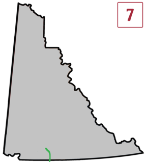
The Atlin Road is a road in British Columbia and Yukon, Canada. It is designated as Highway 7 in Yukon, and has no official highway number in British Columbia.

Unorganized North Algoma District is an unorganized area in northeastern Ontario, Canada, comprising all areas in Algoma District, north of the Sault Ste. Marie to Elliot Lake corridor, which are not part of an incorporated municipality or a First Nation. It covers 44,077.03 km2 (17,018.24 sq mi) of land, and had a population of 5739 in 2016.

Atlin Provincial Park and Recreation Area is a provincial park in British Columbia, Canada. Situated in the remote northwestern corner of the province, the park protects large tracts of boreal forest, alpine tundra and glaciated terrain. The southern third of Atlin Lake, the largest natural body of freshwater in the province, is within the park boundary. The park is very undeveloped; no roads traverse it and no facilities, supplies, developed campsites or maintained hiking trails are available inside the park. The area has become a focal point in controversies involving proposed hydroelectric projects affecting Atlin Lake and environmental groups who view these proposals as potentially damaging to the lake's environment and its surroundings.

Atlin is a community in northwestern British Columbia, Canada, located on the eastern shore of Atlin Lake. In addition to continued gold-mining activity, Atlin is a tourist destination for fishing, hiking and Heliskiing. As of 2004, there are 450 permanent residents.
Thixton is a neighborhood of Louisville, Kentucky centered along Bardstown Road and Thixton Lane.

Rolla is a small historic farming community in the Peace River district of northeastern British Columbia, Canada. It was first founded about 1912 as a way stop and steamer landing on the Peace River. Farms were established as the prairie was open, and the soil was rich. Also, a successful oil well was drilled in 1922 establishing petroleum as an industry in the area.
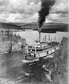
Steamboats on the Yukon River played a role in the development of Alaska and Yukon. Access to the interior of Alaska and Yukon was hindered by large mountains and distance, but the wide Yukon River provided a feasible route. The first steamers on the lower Yukon River were work boats for the Collins Overland Telegraph in 1866 or 1867, with a small steamer called Wilder. The mouth of the Yukon River is far to the west at St. Michael and a journey from Seattle or San Francisco covered some 4,000 miles (6,400 km).
The Nakina River is a river in northwestern British Columbia, Canada, rising southeast of Atlin Lake and flowing generally southeast to its confluence with the Inklin River at the locality of Inklin, where the two rivers combine to form the Taku River.
The Teslin Plateau is a plateau, of the Yukon Plateau physiographic section, in northern British Columbia, Canada, located north of the Nakina River between Atlin Lake and Teslin Lake.
Anderson Bay is a bay of Atlin Lake in northwestern British Columbia, Canada, located southwest of Pike Bay.
The Taku River Tlingit First Nation are the band government of the Inland Tlinkit in far northern British Columbia, Canada and also in Yukon. They comprise two ḵwaan (tribes) of the Tlingit people, who are otherwise coastal, the Áa Tlein Ḵwáan of the Atlin Lake area and the Deisleen Ḵwáan of Teslin Lake, whose main focus is the Teslin Tlingit Council in Teslin, Yukon. Their band offices are in Atlin, British Columbia.

The Stikine Region is an unincorporated area in northwesternmost British Columbia, Canada and is the only area in B.C. not in a regional district. The Stikine Region was left unincorporated following legislation that established the province's regional districts in 1968 and is not classified as a regional district. It contains no municipal governments which normally constitute the majority of seats on the boards of regional districts. There is only one local planning area, the Atlin Community Planning Area, which was combined in 2009 with the Atlin Community Improvement District to provide fire, landfill, water, streetlighting, sidewalks and advisory land use services. All other services not provided privately are administered directly by various provincial government ministries. The area around Dease Lake, formerly in the Stikine Region, is now within the boundaries of the Regional District of Kitimat-Stikine following a boundary amendment in 2008.
Villavelayo is a village in the province and autonomous community of La Rioja, Spain. The municipality covers an area of 89.07 square kilometres (34.39 sq mi) and as of 2011 had a population of 56 people.
Wright Creek is a creek located in the Atlin Country region of British Columbia. The creek flows into the south side of Lake Surprise. It is located 2 miles to east of Otter Creek. The creek was mined for gold. The largest nugget recovered from the creek weighed just over 25 ounces in 1899. The nugget was exhibited at the Paris Exposition in 1900. The creek has been mined using drifting,shovelling-in, sluicing, and hydraulicking.
King Salmon Creek is a creek in the Atlin District of British Columbia, Canada. The creek begins at King Salmon Lake and flows generally eastward to join the Taku River. Southeast of that confluence is King Salmon Mountain.

German submarine U-974 was a Type VIIC U-boat of Nazi Germany's Kriegsmarine during World War II.