
Dorset is a ceremonial county in South West England. It is bordered by Somerset to the north-west, Wiltshire to the north and the north-east, Hampshire to the east, the Isle of Wight across the Solent to the south-east, the English Channel to the south, and Devon to the west. The largest settlement is Bournemouth, and the county town is Dorchester.

Wimborne Minster is a market town in Dorset in South West England, and the name of the Church of England church in that town. It lies at the confluence of the River Stour and the River Allen, 5 miles (8 km) north of Poole, on the Dorset Heaths, and is part of the South East Dorset conurbation. According to Office for National Statistics data the population of the Wimborne Minster built-up area as of 2014 was 15,552.

Bournemouth is a coastal resort town in the Bournemouth, Christchurch and Poole unitary authority area, in the ceremonial county of Dorset, England. The 2021 census built-up area had a population of 196,455, making it the largest town in Dorset.

Poole is a coastal town and seaport on the south coast of England in the Bournemouth, Christchurch and Poole unitary authority area in Dorset, England. The town is 21 miles (34 km) east of Dorchester and adjoins Bournemouth to the east. Since 1 April 2019, the local authority is Bournemouth, Christchurch and Poole Council. The town had an estimated population of 151,500 making it the second-largest town in the ceremonial county of Dorset. Together with Bournemouth and Christchurch, the conurbation has a total population of nearly 400,000.

Blandford Forum is a market town in Dorset, England, on the River Stour, 13 miles (21 km) north-west of Poole. It had a population of 10,355 at the 2021 census.
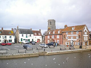
Wareham is a historic market town and, under the name Wareham Town, a civil parish, in the English county of Dorset. The town is situated on the River Frome eight miles (13 km) southwest of Poole.

Sturminster Marshall is a village and civil parish in the east of Dorset in England, situated on the River Stour between Blandford Forum and Poole. The parish had a population of 1,895 at the 2001 census, increasing to 1,969 at the 2011 Census and includes the village of Almer west of Sturminster Marshall, near Winterborne Zelston and the hamlet of Henbury to the south-east of the village. The village is twinned with the French commune of Sainte-Mère-Église in Normandy. The appropriate electoral ward is called 'Stour'. From Sturminster Marshall the ward goes east to Pamphill, with a total population of 2,582.

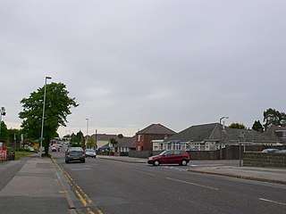
Colehill is a parish neighbouring Wimborne Minster, in Dorset, England. It had a population of 7,000 in 2001, which decreased to 6,927 people at the 2011 census.

Upton is a town in south-east Dorset, England. Upton is to the east of Holton Heath and Upton Heath, and to the north of the Poole suburb of Hamworthy. It is the second largest town in the Purbeck Hills.
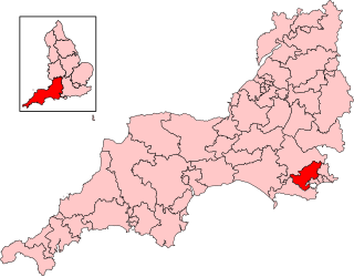
Mid Dorset and North Poole is a constituency represented in the House of Commons of the UK Parliament since 2024 by Vikki Slade, a Liberal Democrat.

Poole is a constituency represented in the House of Commons of the UK Parliament since 2024 by Neil Duncan-Jordan, a Labour politician.

Hamworthy is a suburb of Poole, in the Bournemouth, Christchurch and Poole district, in the ceremonial county of Dorset, England. It is sited on a peninsula of approximately 3 square kilometres (1.2 sq mi) that is bordered by the town of Upton to the north, Poole Harbour to the south, Lytchett Bay to the west and Holes Bay to the east. Poole Bridge, the southern terminus of the A350 road, connects the suburb with the town centre. Hamworthy is the location of the Port of Poole ferry passenger terminal and cargo handling operations.
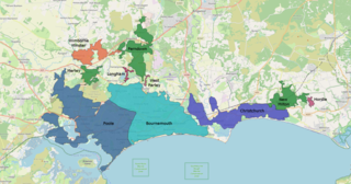
The South East Dorset conurbation is a multi-centred conurbation on the south coast of Dorset in England.

Broadstone is a suburb of Poole in Dorset, England. It is located three miles from Hamworthy railway station and seven miles from Bournemouth International Airport. The ward had a population of 10,303 at the 2011 Census, increasing from 10,256 at the 2001 Census.

Bearwood is a suburb of Poole, Dorset, England. It is centred on a supermarket and medical and neighbourhood centre in King John Avenue.

St James is a Church of England parish church in Poole on the south coast of England, in the ceremonial county of Dorset. The church is located in the historic quarter of the town, near Poole Harbour. It is the parish church for the St James sub district of Poole. Today the church is still in use by the local population and has a large playgroup. Lucy Holt is the current minister of the church.

Creekmoor is a suburb of Poole in Dorset, England, with a population of 9,257, reducing to 9,180 at the 2011 census. Bordered by the Upton Heath Nature Reserve and Upton Country Park, the area is mainly populated by families. The suburb is represented by two local councillors, Judy Butt of the Poole Engage Party and Paul Slade of the Liberal Democrats.
Longfleet is a small district of Poole, in the Bournemouth, Christchurch and Poole district, in the ceremonial county of Dorset, England, centred on Longfleet Road. It is situated directly north of the town centre and lies to the east of Oakdale and to the south and west of Parkstone.
Newtown is a suburb in the town of Poole in Dorset, England. It had a population of 11,132 in 2001, increasing to 12,515 at the 2011 census.
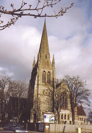
St Mary's, Longfleet is a Church of England parish church in Longfleet, a district of Poole, in the ceremonial county of Dorset, on the south coast of England. It is part of the New Wine network and describes itself as an evangelical charismatic church.

