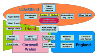
A chambered cairn is a burial monument, usually constructed during the Neolithic, consisting of a sizeable chamber around and over which a cairn of stones was constructed. Some chambered cairns are also passage-graves. They are found throughout Britain and Ireland, with the largest number in Scotland.

The court cairn or court tomb is a megalithic type of chambered cairn or gallery grave. During the period, 3900–3500 BC, more than 390 court cairns were built in Ireland and over 100 in southwest Scotland. The Neolithic monuments are identified by an uncovered courtyard connected to one or more roofed and partitioned burial chambers. Many monuments were built in multiple phases in both Ireland and Scotland and later re-used in the Early Bronze Age.

A gallery grave is a form of megalithic tomb built primarily during the Neolithic Age in Europe in which the main gallery of the tomb is entered without first passing through an antechamber or hallway. There are at least four major types of gallery grave, and they may be covered with an earthen mound or rock mound.

Entrance grave is a type of Neolithic and early Bronze Age chamber tomb found primarily in Great Britain. The burial monument typically consisted of a circular mound bordered by a stone curb, erected over a rectangular burial chamber and accessed by a narrow, stone lined entrance. Entrance graves have been discovered in the Isles of Scilly, west Cornwall, southeast Ireland, southwest Scotland, Brittany and the Channel Islands. They are often referred to as the Scillonian Group, named for the Scillonian Islands where the majority of entrance graves have been discovered.

Bryn Celli DduWelsh pronunciation:[brʌnkeːɬiðɨː] is a prehistoric site on the Welsh island of Anglesey located near Llanddaniel Fab. Its name means 'the mound in the dark grove'. It was archaeologically excavated between 1928 and 1929. Visitors can get inside the mound through a stone passage to the burial chamber, and it is the centrepiece of a major Neolithic Scheduled Monument in the care of Cadw. The presence of a mysterious pillar within the burial chamber, the reproduction of the 'Pattern Stone', carved with sinuous serpentine designs, and the fact that the site was once a henge with a stone circle, and may have been used to plot the date of the summer solstice have all attracted much interest.

Bant's Carn is a Bronze Age entrance grave located on a steep slope on the island of St Mary's in the Isles of Scilly, England. The tomb is one of the best examples of a Scillonian entrance grave. Below Bant's Carn, lies the remains of the Iron Age village of Halangy Down.
Porth Hellick Down is a Neolithic and Bronze Age archeological site located on the island of St Mary's, in the Isles of Scilly in Great Britain. The ancient burial monument encompasses a large cairn cemetery that includes at least six entrance graves, other unchambered cairns, and a prehistoric field system. The site is notable for having the largest assembly of surviving entrance graves.

Gugh could be described as the sixth inhabited island of the Isles of Scilly, but is usually included with St Agnes with which it is joined by a sandy tombolo known as "The Bar" when exposed at low tide. The island is only about 1 km (0.62 mi) long and about 0.5 km (0.31 mi) wide, with the highest point, Kittern Hill at 34 m (112 ft). The geology consists of Hercynian granite with shallow podzolic soils on the higher ground and deeper sandy soils on the lower ground. The former Gugh farm is just north of the neck across the middle of the island between the two hills. The two houses were designed and built in the 1920s by Charles Hamlet Cooper.


Chapel Carn Brea is an elevated Hercynian granite outcrop, owned by the National Trust at the southern edge of the civil parish of St Just, Cornwall, England, United Kingdom. The hill is 5 kilometres (3.1 mi) south of St Just and 3.5 kilometres (2.2 mi) east of Sennen Cove, and just to the north of the A30 London to Land's End road, which runs through the village of Crows-an-Wra. It should not be confused with another Carn Brea, the hill overlooking the Camborne–Redruth area.

The dolmens of Jersey are neolithic sites, including dolmens, in Jersey. They range over a wide period, from around 4800 BC to 2250 BC, these dates covering the periods roughly designated as Neolithic, or “new stone age”, to Chalcolithic, or “copper age”.
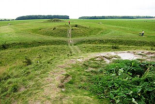
The Cursus Barrows is the name given to a Neolithic and Bronze Age round barrow cemetery lying mostly south of the western end of the Stonehenge Cursus, in Wiltshire, England. The cemetery contains around 18 barrows scattered along an east-to-west ridge, although some of the mounds are no longer visible. The Cursus Barrows can be seen just north of the route between the Stonehenge Visitor Centre and Stonehenge.
Battlegore Burial Chamber is a Bronze Age burial chamber located in Williton, Somerset. It is composed of three round barrows and possibly a long, chambered barrow. The site was excavated in 1931 by George Gray. The name "Battlegore" comes from this site being attributed to the location of a Danish raid in 918 AD or 988 AD. At least as early as the 14th century, the site was referred to as "Bytelgore", a predecessor of the word "Battlegore". Along with three nearby round barrows it has been scheduled as an ancient monument.

The architecture of Scotland in the prehistoric era includes all human building within the modern borders of Scotland, before the arrival of the Romans in Britain in the first century BCE. Stone Age settlers began to build in wood in what is now Scotland from at least 8,000 years ago. The first permanent houses of stone were constructed around 6,000 years ago, as at Knap of Howar, Orkney and settlements like Skara Brae. There are also large numbers of chambered tombs and cairns from this era, particularly in the west and north. In the south and east there are earthen barrows, often linked to timber monuments of which only remnants remain. Related structures include bank barrows, cursus monuments, mortuary enclosures and timber halls. From the Bronze Age there are fewer new buildings, but there is evidence of crannogs, roundhouses built on artificial islands and of Clava cairns and the first hillforts. From the Iron Age there is evidence of substantial stone Atlantic roundhouses, which include broch towers, smaller duns. There is also evidence of about 1,000 hillforts in Scotland, most located below the Clyde-Forth line.
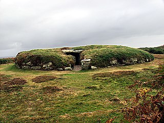
Brane Barrow, or Chapel Euny Barrow, is a Neolithic entrance grave located near the hamlet of Brane, Cornwall, England, UK. It is considered to be one of the smallest and best preserved burial monuments in Britain.

Innisidgen is the site of two Bronze Age entrance graves on the island of St Mary's in the Isles of Scilly. The two burial monuments, lie on a steep slope of Innisidgen Hill overlooking Crow Sound with a view towards the Eastern Isles.
British megalith architecture is the study of those ancient cultures that built megalithic sites on the British Isles, including the research and documentation of these sites. The classification sometimes used of these cultures based on geological criteria is problematic.

Huntersquoy chambered cairn is a Neolithic chambered cairn located on the island of Eday, in Orkney, Scotland. The monument dates from the 3rd millennium BC and is an Orkney–Cromarty type chambered cairn. Huntersquoy is a distinctive two-story burial monument with overlapping chambers. Historic Environment Scotland established the site as a scheduled monument in 1936.

Quanterness chambered cairn is a Neolithic burial monument located on Mainland, Orkney in Scotland. An Iron Age roundhouse built into the cairn was discovered during excavation in the early 1970s. The dwelling was constructed around 700 BC. Also found during excavation, were the remains of 157 people, pottery remnants and other artefacts. Historic Environment Scotland established the site as a scheduled monument in 1929.

The Cornish Bronze Age is an era of the history of Cornwall that spanned the period from c. 2400 BCE to c. 800 BCE. It was preceded by the Cornish Neolithic, and followed by the Cornish Iron Age. It is characterized by the introduction and widespread use of copper and copper-alloy (bronze) weapons and tools.