
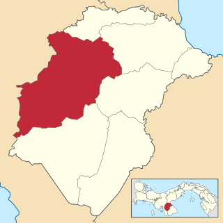
Herrera is a province in Panama. Named after General Tomás Herrera, the province was founded on January 18, 1915 from a division of the Los Santos province. The capital city of Herrera is Chitré, which is located near the province's coastline. Herrera is bordered on the north by the provinces of Veraguas and Coclé, on the south by the province of Los Santos, on the east by Golfo de Parita and the province of Los Santos, and on the west by the province of Veraguas.
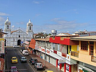
Chitré is a city and corregimiento, the capital of the Panamanian province of Herrera. with a population of 9,092 as of 2010 but in its metropolitan area it has a population of 80,000 inhabitants. It is also the seat of Chitré District. Chitré is located about 7 km inland from the Gulf of Panama on the Azuero Peninsula. The name Chitré comes from the native tribe Chitra. In the city, there is a district, also called Chitré, which is subdivided into five corregimientos. The corregimientos are San Juan Bautista, Llano Bonito, Monagrillo, La Arena and Chitré.

Tolé is a corregimiento in Tolé District, Chiriquí Province, Panama. It is the seat of Tolé District. It has a land area of 76.9 square kilometres (29.7 sq mi) and had a population of 3,240 as of 2010, giving it a population density of 42.1 inhabitants per square kilometre (109/sq mi). Its population as of 1990 was 5,292; its population as of 2000 was 3,156.
Menchaca is a corregimiento in Ocú District, Herrera Province, Panama with a population of 1,517 as of 2010. It was created by Law 41 of April 30, 2003.
Ocú District is a district (distrito) of Herrera Province in Panama. The population according to the 2000 census was 15,936. The district covers a total area of 625 km². The capital lies at the city of Ocú.
Cerro Largo is a corregimiento in Ocú District, Herrera Province, Panama with a population of 1,478 as of 2010. Its population as of 1990 was 2,121; its population as of 2000 was 1,800.
El Tijera is a corregimiento in Ocú District, Herrera Province, Panama with a population of 588 as of 2010. It was created by Law 58 of July 29, 1998, owing to the Declaration of Unconstitutionality of Law 1 of 1982. Its population as of 2000 was 633.
Llano Grande is a corregimiento in Ocú District, Herrera Province, Panama with a population of 1,062 as of 2010. Its population as of 1990 was 1,137; its population as of 2000 was 1,126.
Los Llanos is a corregimiento in Ocú District, Herrera Province, Panama with a population of 2,110 as of 2010. Its population as of 1990 was 3,166; its population as of 2000 was 2,416.
Peñas Chatas is a corregimiento in Ocú District, Herrera Province, Panama with a population of 1,778 as of 2010. Its population as of 1990 was 1,836; its population as of 2000 was 1,811.
Nuario is a corregimiento in Las Tablas District, Los Santos Province, Panama with a population of 182 as of 2010. Its population as of 1990 was 229; its population as of 2000 was 195.
Palmira is a corregimiento in Las Tablas District, Los Santos Province, Panama.
Peña Blanca is a corregimiento in Las Tablas District, Los Santos Province, Panama with a population of 875 as of 2010. Its population as of 1990 was 582; its population as of 2000 was 750.
Río Hondo is a corregimiento in Las Tablas District, Los Santos Province, Panama with a population of 206 as of 2010. Its population as of 1990 was 299; its population as of 2000 was 254.
Valle Rico is a corregimiento in Las Tablas District, Los Santos Province, Panama with a population of 400 as of 2010. Its population as of 1990 was 417; its population as of 2000 was 452.
Mogollón is a corregimiento in Macaracas District, Los Santos Province, Panama with a population of 264 as of 2010. Its population as of 1990 was 359; its population as of 2000 was 293.
Guánico is a corregimiento in Tonosí District, Los Santos Province, Panama with a population of 996 as of 2010. Its population as of 1990 was 1,477; its population as of 2000 was 1,006.
Llano de Catival o Mariato is a corregimiento in Mariato District, Veraguas Province, Panama with a population of 2,376 as of 2010. It is the seat of Mariato District. Its population as of 1990 was 2,052; its population as of 2000 was 2,269.
Montijo is a corregimiento in Montijo District, Veraguas Province, Panama with a population of 2,288 as of 2010. It is the seat of Montijo District. Its population as of 1990 was 4,341; its population as of 2000 was 4,545.
Utira is a corregimiento in Río de Jesús District, Veraguas Province, Panama with a population of 314 as of 2010. Its population as of 1990 was 393; its population as of 2000 was 318.

