
Fleet is a town and civil parish in the Hart District of Hampshire, England, centred 38 miles (61 km) south-west of London and 13 miles (21 km) east of Basingstoke.

Hart is a local government district in Hampshire, England, named after the River Hart. Its council is based in Fleet. The district also contains the towns of Blackwater and Yateley, along with numerous villages and surrounding rural areas.

Hartley Wintney is a large village and civil parish in the Hart district of Hampshire, England. It lies about 3 miles (5 km) northwest of Fleet and 8 miles (13 km) east of Basingstoke. The parish includes the smaller contiguous village of Phoenix Green as well as the hamlets of Dipley, Elvetham, Hartfordbridge, and West Green.

Basingstoke is a constituency in Hampshire represented in the House of Commons of the UK Parliament since 2024 by Luke Murphy, a member of the Labour Party.

North East Hampshire is a constituency represented in the House of Commons of the UK Parliament by Alex Brewer, a Liberal Democrat.
Liss is a village and civil parish in the East Hampshire district of Hampshire, 3.3 miles (5.3 km) north-east of Petersfield, on the A3 road, on the West Sussex border. It covers 3,567 acres (14 km2) of semi-rural countryside in the South Downs National Park. Liss railway station is on the Portsmouth Direct line. The village comprises an old village at West Liss and a modern village round the 19th-century station. They are divided by the River Rother. Suburbs later spread towards Liss Forest.

Lasham is a village and civil parish in the East Hampshire district of Hampshire, England. It is 3.4 miles (5.5 km) northwest of Alton and 1.2 miles (1.9 km) north of Bentworth, just off the A339 road. The parish covers an area of 1,797 acres (727 ha) and has an average elevation of 560 feet (170 m) above sea level. The nearest railway station is Alton, 3.5 miles (5.6 km) southeast of the village. Lasham formerly had its own railway station, Bentworth and Lasham, on the Basingstoke and Alton Light Railway until the line's closure in 1936. According to the 2011 census, the village had a population of 176.
Sherfield on Loddon—formerly Sherfield upon Loddon—is a village and civil parish in the English county of Hampshire. It is located at grid reference SU680580, approximately 12 miles (19 km) south of Reading and 6 miles (10 km) north of Basingstoke.

Bentworth is a village and civil parish in the East Hampshire district of Hampshire, England. The nearest town is Alton, which lies about 3 miles (5 km) east of the village. It sits within the East Hampshire Hangers, an area of rolling valleys and high downland. The parish covers an area of 3,763 acres (15.23 km2) and at its highest point is the prominent King's Hill, 716 feet (218 m) above sea level. According to the 2011 census, Bentworth had a population of 553.

Winchfield is a small village in the Hart District of Hampshire in the South-East of England. It is situated 1 mile (1.6 km) south-west of Hartley Wintney, 8 miles (13 km) east of Basingstoke, 2 miles (3.2 km) north-east of Odiham and 38 miles (61 km) west of London. It is connected to London Waterloo and Basingstoke by the South West Main Line.
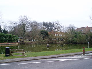
Dogmersfield is a small village lying between the towns of Fleet and Hartley Wintney in Hampshire, England. The M3 motorway and railway stations at Fleet and Winchfield provide routes to London.

The River Whitewater rises at springs near Bidden Grange Farm between Upton Grey and Greywell in Hampshire, England. It flows northeast and is a tributary of the River Blackwater near Swallowfield. Its headwaters flow over chalk and there is little pollution making the River Whitewater rich in wildlife. It was noted on Jansson's map of Hampshire of 1646.

Shalden is a village and civil parish in the East Hampshire district of Hampshire, England. It is 2.3 miles (3.7 km) northwest of Alton and 1.9 miles (3.1 km) northeast of Bentworth, just off the A339 road. The parish covers an area of 1,536 acres (622 ha) and has an average elevation of 600 feet (180 m) above sea level. The nearest railway station is Alton, 2.5 miles (4.0 km) southeast of the village. According to the 2011 census, it had a population of 435.

Weston Patrick is a small village and civil parish in Hampshire. It lies four miles (6 km) southeast from Basingstoke and covers an area of 1,183 acres (4.79 km2). Weston Patrick is divided from the neighbouring parish of Weston Corbett by the road leading to the village of Upton Grey.
Burkham is a hamlet in the large civil parish of Bentworth in Hampshire, England including a large country house, Burkham House. The nearest town is Alton, which lies about 4.5 miles (7.2 km) to the south-east. Its nearest railway station was formerly the Bentworth and Lasham railway station on the Basingstoke and Alton Light Railway, until its closure in 1932. The nearest railway station is now 3.6 miles (5.8 km) east of the village, at Alton.

The Hundred of Meonstoke was a small Hundred of Great Britain situated in the ceremonial county of Hampshire. The Hundred of Meonstoke contained the parishes of; Abbots Worthy, Alverstoke, Corhampton, Exton, Hambledon, Liss, Meonstoke, Soberton, Warnford, and West Meon. Before the time of the Domesday Survey, Bramdean was included in the Meonstoke Hundred until it was transferred to the Finchdean Hundred. The land comprising the hundred was assessed in the reign of Edward the Confessor at 89 hides, and at the time of the Domesday survey of 1086 was estimated to be about 56 hides and comprised 12 places in Hampshire.

Hall Place is a manor house in the civil parish of Bentworth in Hampshire, England. It is about 300 metres (980 ft) southwest of St Mary's Church and 3.6 miles (5.8 km) northwest of Alton, the nearest town. Built in the early 14th century, it is a Grade II listed medieval hall house, known by various names through the centuries. It is 0.5 miles (0.8 km) from the current Bentworth Hall that was built in 1832.

The River Hart is a tributary of the River Whitewater in north Hampshire, England. It rises at Ashley Head spring in Crondall and flows north to meet the Whitewater at Bramshill.
