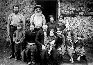
Boer is the Dutch and Afrikaans noun for "farmer". In South African contexts, "Boers" refers to the descendants of the then Dutch-speaking settlers of the eastern Cape frontier in Southern Africa during the 18th and much of the 19th century. From 1652 to 1795 the Dutch East India Company controlled this area, but the United Kingdom incorporated it into the British Empire in 1806.

Portuguese Mozambique or Portuguese East Africa are the common terms by which Mozambique is designated when referring to the historic period when it was a Portuguese overseas territory. Portuguese Mozambique constituted a string of Portuguese colonies and later a single Portuguese overseas province along the south-east African coast, which now forms the Republic of Mozambique.
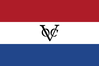
The written history of the Cape Colony in what is now South Africa began when Portuguese navigator Bartolomeu Dias became the first modern European to round the Cape of Good Hope in 1488. In 1497, Vasco da Gama sailed along the whole coast of South Africa on his way to India, landed at St Helena Bay for 8 days, and made a detailed description of the area. The Portuguese, attracted by the riches of Asia, made no permanent settlement at the Cape Colony. However, the Dutch East India Company (VOC) settled the area as a location where vessels could restock water and provisions.

Northern Rhodesia was a protectorate in south central Africa, formed in 1911 by amalgamating the two earlier protectorates of Barotziland-North-Western Rhodesia and North-Eastern Rhodesia. It was initially administered, as were the two earlier protectorates, by the British South Africa Company (BSAC), a chartered company on behalf of the British Government. From 1924 it was administered by the British Government as a protectorate under similar conditions to other British-administered protectorates, and the special provisions required when it was administered by BSAC were terminated.

The Virginia Peninsula is a peninsula in southeast Virginia, USA, bounded by the York River, James River, Hampton Roads and Chesapeake Bay. It is sometimes known as the Lower Peninsula to distinguish it from two other peninsulas to the north, the Middle Peninsula and the Northern Neck.

Schutztruppe was the official name of the colonial troops in the African territories of the German colonial empire from the late 19th century to 1918. Similar to other colonial armies, the Schutztruppen consisted of volunteer European commissioned and non-commissioned officers, medical and veterinary officers. Most enlisted ranks were generally recruited locally.

General Sir Richard Bourke, KCB, was an Irish-born British Army officer who served as Governor of New South Wales from 1831 to 1837. As a lifelong Whig (Liberal), he encouraged the emancipation of convicts and helped bring forward the ending of penal transportation to Australia. In this, he faced strong opposition from the military/conservative establishment and its press. He approved a new settlement on the Yarra River, and named it Melbourne, in honour of the incumbent British prime minister, Lord Melbourne.

The German colonial empire constituted the overseas colonies, dependencies and territories of Imperial Germany. Unified in the early 1870's, the chancellor of this time period was Otto von Bismarck. Short-lived attempts of colonization by individual German states had occurred in preceding centuries, but crucial colonial efforts only began in 1884 with the Scramble for Africa. Claiming much of the left-over colonies in the Scramble for Africa, Germany managed to build the third largest colonial empire after the British and French, at the time. Germany lost control when World War I began in 1914 and its colonies were seized by its enemies in the first weeks of the war. However some military units held out for a while longer: German South West Africa surrendered in 1915, Kamerun in 1916 and German East Africa at the end of the war, the defenders of which having been engaged in a guerrilla war with British and colonial forces, as well as the Portuguese. Germany's colonial empire was officially confiscated with the Treaty of Versailles after Germany's defeat in the war and the various units became League of Nations mandates under the supervision of one of the victorious powers. The German Colonial empire officially existed until 1919. Plans to regain their lost colonial possessions persisted through WW2, some people at the time suspecting that was the goal of the Third Reich all along. Despite not being around for a very long time, Germanys colonial ventures changed the places and people they came into contact with. The Germans participated in medicinal and scientific research in Africa, as well as attempting to build up an infrastructure there. However, they also shed a lot of African blood and killed many to make these things possible.
The British South Africa Company was established following the amalgamation of Cecil Rhodes' Central Search Association and the London-based Exploring Company Ltd which had originally competed to exploit the expected mineral wealth of Mashonaland but united because of common economic interests and to secure British government backing. The company received a Royal Charter in 1889 modelled on that of the British East India Company. Its first directors included the Duke of Abercorn, Rhodes himself and the South African financier Alfred Beit. Rhodes hoped BSAC would promote colonisation and economic exploitation across much of south-central Africa, as part of the "Scramble for Africa". However, his main focus was south of the Zambezi, in Mashonaland and the coastal areas to its east, from which he believed the Portuguese could be removed by payment or force, and in the Transvaal, which he hoped would return to British control.

Atlanta Bread Company is a privately owned bakery cafe chain established in the United States in 1993. By 1995, the owners began franchising and expanding across the country.

The Dutch colonial empire comprised the overseas territories and trading posts controlled and administered by Dutch chartered companies and subsequently by the Dutch Republic (1581–1795), and by the modern Kingdom of the Netherlands after 1815. It was initially a trade-based system which derived most of its influence from merchant enterprise and from Dutch control of international maritime shipping routes through strategically placed outposts, rather than from expansive territorial ventures. With a few notable exceptions, the majority of the Dutch colonial empire's overseas holdings consisted of coastal forts, factories, and port settlements with varying degrees of incorporation of their hinterlands and surrounding regions. Dutch chartered companies often dictated that their possessions be kept as confined as possible in order to avoid unnecessary expense, and while some such as the Dutch Cape Colony and Dutch East Indies expanded anyway, others remained undeveloped, isolated trading centres dependent on an indigenous host-nation. This reflected the primary purpose of the Dutch colonial empire: commercial exchange as opposed to sovereignty over homogeneous landmasses.

East Africa Protectorate was an area in the African Great Lakes occupying roughly the same terrain as present-day Kenya from the Indian Ocean inland to the border with Uganda in the west. Although part of the dominions of the Sultanate of Zanzibar, it was controlled by Britain in the late 19th century; it grew out of British commercial interests in the area in the 1880s and remained a protectorate until 1920 when it became the colony of Kenya, save for an independent country 16-kilometre-wide (10 mi) coastal strip that became the Kenya protectorate.
White people in Kenya or White Kenyans, are those born in or resident in Kenya who descend from Europeans and/or identify themselves as white. There is currently a minor but relatively prominent white community in Kenya, mainly descended from British, but also to a lesser extent Italian and Greek, migrants dating from the colonial period.

Maltahöhe is a village in southern central Namibia close to the Swartrand escarpment, about 110 km west of Mariental in the Hardap Region. It has about 6,000 inhabitants and owns about 17,000 hectares of land. Maltahöhe has two suburbs, the Andreville location and the Blikkiesdorp informal settlement which has neither sewerage nor electricity supply. It is served by Maltahöhe Railway Station.
The Khoikhoi–Dutch Wars were a series of conflicts that took place in the last half of the 17th century in what was known then as the Cape of Good Hope, in the area of present-day Cape Town, South Africa, between Dutch settlers who came from the Netherlands and the local African people, the indigenous Khoikhoi, who had lived in that part of the world for millennia.

The Cape Colony was a Dutch East India Company colony in Southern Africa, centered on the Cape of Good Hope, whence it derived its name. The original colony and its successive states that the colony was incorporated into occupied much of modern South Africa. Between 1652 and 1691 a Commandment, and between 1691 and 1795 a Governorate of the Dutch East India Company. Jan van Riebeeck established the colony as a re-supply and layover port for vessels of the Dutch East India Company trading with Asia. The Cape came under Dutch rule from 1652 to 1795 and again from 1803 to 1806. Much to the dismay of the shareholders of the Dutch East India Company, who focused primarily on making profits from the Asian trade, the colony rapidly expanded into a settler colony in the years after its founding.

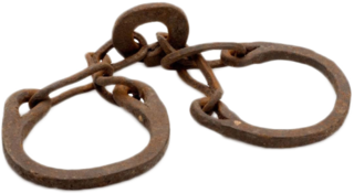
Slavery in South Africa existed until the abolition of slavery in 1834.

Upingtonia, or the Republic of Upingtonia, was a short-lived Boer republic in the area of present-day Namibia. Declared on 20 October 1885, in 1886 it changed its name to Lijdensrust. In 1887 it was merged into German South-West Africa.

The Merikins or Merikens were African-American Marines of the War of 1812 – former African slaves who fought for the British against the USA in the Corps of Colonial Marines and then, after post-war service in Bermuda, were established as a community in the south of Trinidad and Tobago in 1815–16. They were settled in an area populated by French-speaking Catholics and retained cohesion as an English-speaking, Baptist community. It is sometimes said that the term "Merikins" derived from the local patois, but as many Americans have long been in the habit of dropping the initial 'A' it seems more likely that the new settlers brought that pronunciation with them from the United States. Some of the Company villages and land grants established back then still exist in Trinidad today.


