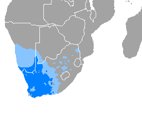
Afrikaans is a West Germanic language that evolved in the Dutch Cape Colony from the Dutch vernacular of Holland proper used by Dutch, French, and German settlers and people enslaved by them. Afrikaans gradually began to develop distinguishing characteristics during the course of the 18th century. Now spoken in South Africa, Namibia and Botswana, Zambia, and Zimbabwe, estimates c. 2010 of the total number of Afrikaans speakers range between 15 and 23 million. Most linguists consider Afrikaans to be a partly creole language.

Curtisia dentata is a flowering tree from Southern Africa. It is the sole species in genus Curtisia, which was originally classed as a type of "dogwood" (Cornaceae), but is now placed in its own unique family Curtisiaceae.

Paarl is a town with 285,574 inhabitants in the Western Cape province of South Africa. It is the third-oldest city and European settlement in the Republic of South Africa and the largest town in the Cape Winelands. Due to the growth of the Mbekweni township, it is now a de facto urban unit with Wellington. It is situated about 60 kilometres (37 mi) northeast of Cape Town in the Western Cape Province and is known for its scenic environment and viticulture and fruit-growing heritage.
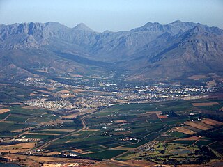
Stellenbosch is a town in the Western Cape province of South Africa, situated about 50 kilometres east of Cape Town, along the banks of the Eerste River at the foot of the Stellenbosch Mountain. The town became known as the City of Oaks or Eikestad in Afrikaans and Dutch due to the large number of oak trees that were planted by its founder, Simon van der Stel, to grace the streets and homesteads.
Orania is a town founded by Afrikaners and an unrecognised micronation in South Africa. It is located along the Orange River in the Karoo region of the Northern Cape province. The town is split in two halves by the R369 road, and is 871 kilometres (541 mi) from Cape Town and approximately 680 kilometres (420 mi) from Pretoria. Its climate is semi-arid.

Stellenbosch University is a public research university situated in Stellenbosch, a town in the Western Cape province of South Africa. Stellenbosch is the oldest university in South Africa and the oldest extant university in Sub-Saharan Africa, together with the University of Cape Town - which received full university status on the same day in 1918. Stellenbosch University designed and manufactured Africa's first microsatellite, SUNSAT, launched in 1999.

Kuruman is a small town in the Northern Cape province of South Africa. It is known for its scenic beauty and the Eye of Kuruman, a geological feature that brings water from deep underground. The abundance of water produces an unexpected swathe of green amidst the barren plains and is known as the Oasis of the Kalahari. It was at first a mission station of the London Missionary Society founded by Robert Moffat in 1821. It was also the place where David Livingstone arrived for his first position as a missionary in 1841. The Kuruman River, which is dry except for flash floods after heavy rain, is named after the town.

The Wonderboom Nature Reserve is a 1 km², 200-hectare reserve that incorporates a section of the Magaliesberg range in the northern portion of the Pretoria metropole, South Africa. Its main attractions are the Wonderboom near the reserve entrance in Lavender street and the derelict Fort Wonderboompoort on the crest of the Magaliesberg, that was constructed towards the end of the nineteenth century, during the Second Boer War. The latter is reached by following the steep, paved walkway that leads from the picnic area to the summit. The vicinity of the fort ruins also afford sweeping views of the city, whose council declared the area around the Wonderboom and both banks of the Apies River a reserve on 28 December 1949.
Memel is a town in the Free State province of South Africa, located close to the provincial boundaries of both kwaZulu-Natal and Mpumalanga, and is situated some 1,730 metres above sea level.

Petrus Steyn, is a small farming town between Tweeling and Kroonstad, 35 km north-east of Lindley in the Free State province of South Africa. It is at the centre of an agricultural area known for wheat, maize, sunflower, potato, cattle, hunting, sheep production and forms part of the breadbasket in the Free State. It is the highest town above sea level in the Free State.

Tzaneen is a large tropical garden town situated in the Mopani District Municipality of the Limpopo province in South Africa. It is situated in a high rainfall fertile region with tropical and subtropical agriculture taking place in a 20,000 square kilometres (7,700 sq mi) region. It is Limpopo's second largest town after Polokwane.
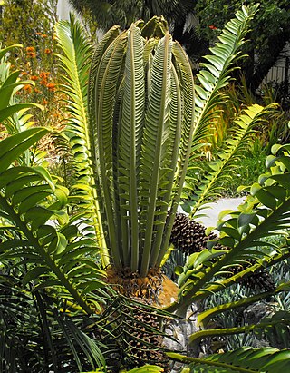
Encephalartos transvenosus is a palm-like cycad in the family Zamiaceae, with a localized distribution in Limpopo, South Africa. Its common names, Modjadji's cycad or Modjadji's palm, allude to the female dynasty of the Lobedu people, the Rain Queens, whose hereditary name is Modjadji. The queen resides near a valley which is densely forested with these cycads, which they protected and hold sacred. The species name transvenosus refers to the fine network of veins between the main veins. These can be seen when the leaf is held up to the light.

Helderberg refers to a planning district of the City of Cape Town metropolitan municipality, the mountain after which it is named, a wine-producing area in the Western Cape province of South Africa, or a small census area in Somerset West.

Williston is a town in Northern Cape, South Africa. Town 103 km north-east of Calvinia and 140 km south-west of Carnarvon.

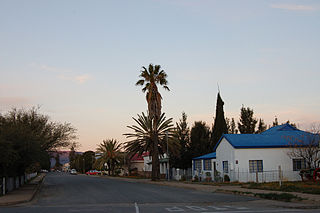
Loxton is a town in the Karoo region of South Africa's Northern Cape province. Within the Ubuntu Local Municipality of the Pixley ka Seme District Municipality
Calvinia is a regional town in the Northern Cape province of South Africa named after the French religious reformer Jean Calvin. The town falls under the Hantam Local Municipality which forms part of the Namakwa District Municipality. The Calvinia district is part of the Great Karoo region of South Africa. The town is just south of the Hantam mountains on the banks of the Oorlogskloof River.
Goodwood is a suburb of Cape Town in the Western Cape, South Africa and is situated in the Tygerberg region of the City of Cape Town. It is 10 kilometres from Cape Town and accessible from the N1, N7 and N2 highways.
Pearston is a small town in the eastern Karoo, in the Eastern Cape province of South Africa. It lies between Graaff-Reinet and Somerset East at the foot of the Coetzeesberge, about 160 kilometres (100 mi) north of Port Elizabeth. It falls within the Blue Crane Route Local Municipality and has a population of approximately 4,500 people.

Namibia is a multilingual country wherein German is recognised as a national language. While English has been the sole official language of the country since 1990, in many areas of the country, German enjoys official status at a community level.


