Related Research Articles

A suburb is an area within a metropolitan area which often contains most of the area's economic activity, which may include commercial and mixed-use. A suburb can exist either as part of a larger city/urban area or as a separate political entity. The name describes an area that is either more or less densely populated than an inner city. In many metropolitan areas suburbs rise in population during the day and are where most jobs are located; being major commercial and job hubs, many suburbs also exist as separate residential communities within commuting distance of a larger city. Suburbs can have their own political or legal jurisdiction, especially in the United States, but this is not always the case, especially in the United Kingdom, where most suburbs are located within the administrative boundaries of cities. In most English-speaking countries, suburban areas are defined in contrast to central city or inner city areas, but in Australian English and South African English, suburb has become largely synonymous with what is called a "neighborhood" in the U.S., but it is used in contrast with inner city areas.

Smart growth is an urban planning and transportation theory that concentrates growth in compact walkable urban centers to avoid sprawl. It also advocates compact, transit-oriented, walkable, bicycle-friendly land use, including neighborhood schools, complete streets, and mixed-use development with a range of housing choices. The term "smart growth" is particularly used in North America. In Europe and particularly the UK, the terms "compact city", "urban densification" or "urban intensification" have often been used to describe similar concepts, which have influenced government planning policies in the UK, the Netherlands and several other European countries.
An urban growth boundary, or UGB, is a regional boundary, set in an attempt to control urban sprawl by, in its simplest form, mandating that the area inside the boundary be used for urban development and the area outside be preserved in its natural state or used for agriculture. Legislating for an "urban growth boundary" is one way, among many others, of managing the major challenges posed by unplanned urban growth and the encroachment of cities upon agricultural and rural land.

A town is a type of a human settlement. Towns are generally larger than villages and smaller than cities, though the criteria to distinguish between them vary considerably in different parts of the world.
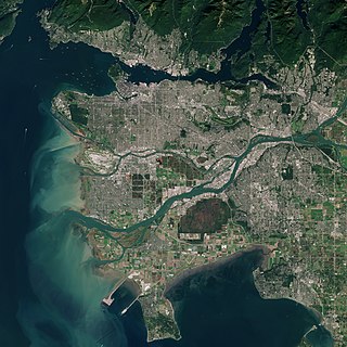
The Metro Vancouver Regional District (MVRD), or simply Metro Vancouver, is a Canadian political subdivision and corporate entity representing the metropolitan area of Greater Vancouver, designated by provincial legislation as one of the 28 regional districts in British Columbia. The organization was known as the Regional District of Fraser–Burrard for nearly one year upon incorporating in 1967, and as the Greater Vancouver Regional District (GVRD) from 1968 to 2017.
The Metropolitan Council, commonly abbreviated Met Council or Metro Council, is the regional governmental agency and metropolitan planning organization in Minnesota serving the Twin Cities seven-county metropolitan area, accounting for over 55 percent of the state's population.
Land use planning is the process of regulating the use of land by a central authority. Usually, this is done to promote more desirable social and environmental outcomes as well as a more efficient use of resources. More specifically, the goals of modern land use planning often include environmental conservation, restraint of urban sprawl, minimization of transport costs, prevention of land use conflicts, and a reduction in exposure to pollutants. In the pursuit of these goals, planners assume that regulating the use of land will change the patterns of human behavior, and that these changes are beneficial. The first assumption, that regulating land use changes the patterns of human behavior is widely accepted. However, the second assumption - that these changes are beneficial - is contested, and depends on the location and regulations being discussed.
In urban planning, transit-oriented development (TOD) is a type of urban development that maximizes the amount of residential, business and leisure space within walking distance of public transport. It promotes a symbiotic relationship between dense, compact urban form and public transport use. In doing so, TOD aims to increase public transport ridership by reducing the use of private cars and by promoting sustainable urban growth.
A charrette, often Anglicized to charette or charet and sometimes called a design charrette, is an intense period of design or planning activity.

A Metropolitan Planning Organization (MPO) is a federally mandated and federally funded transportation policy-making organization in the United States that is made up of representatives from local government and governmental transportation authorities. They were created to ensure regional cooperation in transportation planning. MPOs were introduced by the Federal-Aid Highway Act of 1962, which required the formation of an MPO for any urbanized area (UZA) with a population greater than 50,000. Federal funding for transportation projects and programs are channeled through this planning process. Congress created MPOs in order to ensure that existing and future expenditures of governmental funds for transportation projects and programs are based on a continuing, cooperative, and comprehensive ("3-C") planning process. Statewide and metropolitan transportation planning processes are governed by federal law. Transparency through public access to participation in the planning process and electronic publication of plans now is required by federal law. As of 2015, there are 408 MPOs in the United States.
The term "sustainable communities" has various definitions, but in essence refers to communities planned, built, or modified to promote sustainable living. Sustainable communities tend to focus on environmental and economic sustainability, urban infrastructure, social equity, and municipal government. The term is sometimes used synonymously with "green cities," "eco-communities," "livable cities" and "sustainable cities."

The municipal government of Toronto is the local government responsible for administering the city of Toronto in the Canadian province of Ontario. Its structure and powers are set out in the City of Toronto Act.

Environmental planning is the process of facilitating decision making to carry out land development with the consideration given to the natural environment, social, political, economic and governance factors and provides a holistic framework to achieve sustainable outcomes. A major goal of environmental planning is to create sustainable communities, which aim to conserve and protect undeveloped land.

The Lents neighborhood in the Southeast section of Portland, Oregon is bordered by SE Powell Blvd. on the north, the Clackamas County line or City of Portland line on the south, SE 82nd Ave. to the west, and roughly SE 112th on the east. The NE corner overlaps with the Powellhurst-Gilbert neighborhood. In addition to Powellhurst-Gilbert on the north and east, Lents also borders Foster-Powell, Mt. Scott-Arleta, and Brentwood-Darlington on the west and Pleasant Valley on the east.
A townsite is a legal subdivision of land for the development of a town or community. In the historical development of the United States, Canada, and other former British colonial nations, the filing of a townsite plat or plan (Canada) was often the first legal act in the establishment of a new town or community.
Comprehensive planning is an ordered process that determines community goals and aspirations in terms of community development. The end product is called a comprehensive plan, also known as a general plan, or master plan. This resulting document expresses and regulates public policies on transportation, utilities, land use, recreation, and housing. Comprehensive plans typically encompass large geographical areas, a broad range of topics, and cover a long-term time horizon. The term comprehensive plan is most often used by urban planners in the United States.
An urban Indian reserve is land that the Government of Canada has designated as a First Nations reserve that is situated within an urban area. Such lands allow for aboriginal commercial ventures which enjoy the tax exemptions offered to traditional reserves. They may be located within either a municipality or, in the case of Saskatchewan, a Northern Administration District.

Vancouverism is an urban planning and architectural phenomenon in Vancouver, British Columbia, Canada. It is characterized by a large residential population living in the city centre with mixed-use developments, typically with a medium-height, commercial base and narrow, high-rise residential towers, significant reliance on mass public transit, creation and maintenance of green park spaces, and preserving view corridors. The architect Bing Thom described Vancouverism this way:
It's a spirit about public space. I think Vancouverites are very, very proud that we built a city that really has a tremendous amount of space on the waterfront for people to recreate and to enjoy. At the same time, False Creek and Coal Harbour were previously industrial lands that were very polluted and desecrated. We've refreshed all of this with new development, and people have access to the water and the views. So, to me, it's this idea of having a lot people living very close together, mixing the uses. So, we have apartments on top of stores. In Surrey we have a university on top of a shopping centre. This mixing of uses reflects Vancouver in terms of our culture and how we live together.
The Growth Plan for the Greater Golden Horseshoe, 2006 is a regional growth management policy for the Greater Golden Horseshoe (GGH) area of southern Ontario, Canada. Introduced under the Places to Grow Act in 2005, the Plan was approved by the Lieutenant Governor in Council and enacted on June 16, 2006. Administered by the Ontario Ministry of Infrastructure (MOI), the plan identifies density and intensification targets, urban growth centres, strategic employment areas, and settlement area restrictions designed to mitigate negative environmental, economic, and human health impacts associated with sprawling, uncoordinated growth in the region.
Complete communities is an urban and rural planning concept that aims to meet the basic needs of all residents in a community, regardless of income, culture, or political ideologies through integrated land use planning, transportation planning, and community design. While the concept is used by many communities as part of their community plan, each plan interprets what complete community means in their own way. The idea of the complete community has roots in early planning theory, beginning with The Garden City Movement, and is a component of contemporary planning methods including Smart Growth.
References
- ↑ "City of North Vancouver Official Community Plan 2002, Historical overview" (PDF). Archived from the original (PDF) on 2006-07-11. Retrieved 2010-01-24.
- ↑ Report outlining the neighborhood planning process for Dunbar neighborhood in Vancouver