Ognen Danov | |
---|---|
Village | |
Country | |
Province | Burgas Province |
Municipality | Karnobat Municipality |
Time zone | EET (UTC+2) |
• Summer (DST) | EEST (UTC+3) |
Ognen is a village in Karnobat Municipality, in Burgas Province, in southeastern Bulgaria. [1]
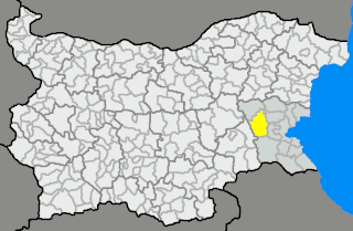
Karnobat Municipality is a municipality in Burgas Province, Bulgaria. It includes the town of Karnobat and a number of villages.
Burgas Province is a province in southeastern Bulgaria, including southern Bulgarian Black Sea Coast. The province is named after its administrative and industrial centre - the city of Burgas - the fourth biggest town in the country. It is the largest province by area, embracing a territory of 7,748.1 km2 (2,991.6 sq mi) that is divided into 13 municipalities with a total population, as of December 2009, of 422,319 inhabitants.
Bulgaria, officially the Republic of Bulgaria, is a country in Southeast Europe. It is bordered by Romania to the north, Serbia and North Macedonia to the west, Greece and Turkey to the south, and the Black Sea to the east. The capital and largest city is Sofia; other major cities are Plovdiv, Varna and Burgas. With a territory of 110,994 square kilometres (42,855 sq mi), Bulgaria is Europe's 16th-largest country.
Ognen Cove on Trinity Peninsula, Antarctica is named after the village.
Ognen Cove is the 2.8 km wide cove indenting for 1.55 km the northwest coast of Trinity Peninsula in Graham Land, Antarctica. It is part of Charcot Bay entered west of Nikyup Point, and formed as a result of the retreat of Andrew Glacier in the second half of 20th century.
Trinity Peninsula is the northernmost part of the Antarctic Peninsula. It extends northeastward for about 130 km (80 mi) to Cape Dubouzet from an imaginary line connecting Cape Kater on the north-west coast and Cape Longing on the south-east coast. Prime Head is the northernmost point of this peninsula. Some 20 kilometers southeast of Prime Head is Hope Bay with the year-round Argentinian Esperanza Base.
Antarctica is Earth's southernmost continent. It contains the geographic South Pole and is situated in the Antarctic region of the Southern Hemisphere, almost entirely south of the Antarctic Circle, and is surrounded by the Southern Ocean. At 14,200,000 square kilometres, it is the fifth-largest continent. For comparison, Antarctica is nearly twice the size of Australia. About 98% of Antarctica is covered by ice that averages 1.9 km in thickness, which extends to all but the northernmost reaches of the Antarctic Peninsula.
Valchedram is a town in northwestern Bulgaria, part of Montana Province. It is the administrative centre of Valchedram Municipality, which lies in the northeastern part of Montana Province. As of December 2009, the town has a population of 3,817 inhabitants.
Baktüttös is a village in Zala County, Hungary.
Sini Rid is a village in Ruen Municipality, in Burgas Province, in southeastern Bulgaria.
Malusha is a village in Gabrovo Municipality, in Gabrovo Province, in northern central Bulgaria.
Ruychovtsi is a village in Gabrovo Municipality, in Gabrovo Province, in northern central Bulgaria.
Dolni Radkovtsi is a village in Tryavna Municipality, in Gabrovo Province, in northern central Bulgaria.
Enchovtsi is a village in Tryavna Municipality, in Gabrovo Province, in northern central Bulgaria.
Gorni Damyanovtsi is a village in Tryavna Municipality, in Gabrovo Province, in northern central Bulgaria.
Gorni Radkovtsi is a village in Tryavna Municipality, in Gabrovo Province, in northern central Bulgaria.
Irinetsi is a village in Tryavna Municipality, in Gabrovo Province, in northern central Bulgaria.
Kolyu Ganev is a village in Tryavna Municipality, in Gabrovo Province, in northern central Bulgaria.
Konarskoto is a village in Tryavna Municipality, in Gabrovo Province, in northern central Bulgaria.
Marutsekovtsi is a village in Tryavna Municipality, in Gabrovo Province, in northern central Bulgaria.
Nozherite is a village in Tryavna Municipality, in Gabrovo Province, in northern central Bulgaria.
Noseite is a village in Tryavna Municipality, in Gabrovo Province, in northern central Bulgaria.
Radino is a village in Tryavna Municipality, in Gabrovo Province, in northern central Bulgaria.
Svirtsi is a village in Tryavna Municipality, in Gabrovo Province, in northern central Bulgaria.
Vlasatili is a village in Tryavna Municipality, in Gabrovo Province, in northern central Bulgaria.
Navalgatti is a village in Belgaum district of Karnataka, India.
Chernitsa is a village in Sungurlare Municipality, in Burgas Province, in southeastern Bulgaria.
Coordinates: 42°42′N26°49′E / 42.700°N 26.817°E
A geographic coordinate system is a coordinate system that enables every location on Earth to be specified by a set of numbers, letters or symbols. The coordinates are often chosen such that one of the numbers represents a vertical position and two or three of the numbers represent a horizontal position; alternatively, a geographic position may be expressed in a combined three-dimensional Cartesian vector. A common choice of coordinates is latitude, longitude and elevation. To specify a location on a plane requires a map projection.
This Burgas Province, Bulgaria location article is a stub. You can help Wikipedia by expanding it. |