State Route 335 is a north–south state highway in the southern portion of the U.S. state of Ohio. Its southern terminus is at US 52 in Sciotoville, a neighborhood within the city of Portsmouth, and its northern terminus is at SR 220 in Waverly where it has a wrong-way concurrency with US 23 and SR 104 for 0.35 miles (0.56 km).

State Route 348 (SR 348) is an east–west state highway in the south central portion of the U.S. state of Ohio. Its western terminus is at State Route 125 approximately 6 miles (9.7 km) east of West Union, and its eastern terminus is at U.S. Route 23 just north of Lucasville – this is also the western terminus of State Route 728.

State Route 243 is an east–west state highway in the southern portion of the U.S. state of Ohio. The western terminus of SR 243 is at a diamond interchange with the U.S. Route 52 (US 52) in Coal Grove. The eastern terminus of the state highway is at its signalized junction with State Route 7 approximately 1.25 miles (2.01 km) west of Proctorville near the northern banks of the Ohio River.

State Route 31 (SR 31) is a 32.12-mile-long (51.69 km) Ohio State Route that runs between Marysville and Kenton in the US state of Ohio. The southern terminus of SR 31 is at an intersection with SR 38 in downtown Marysville and the northern terminus is at an intersection with U.S. Route 68 (US 69), in downtown Kenton. None of the highway is listed on the National Highway System. Most of the route is a rural two-lane highway and passes through both farmland and residential properties.

State Route 167 is a 14.08-mile-long (22.66 km) east–west state highway in the northeastern portion of the U.S. state of Ohio. Its western terminus is at the northern end of the SR 46 and SR 307 concurrency in Jefferson, and its eastern terminus is at the Pennsylvania state line about 13 miles (21 km) south of Conneaut, where Pennsylvania Route 198 continues east. The route was designated in 1923, and has been rerouted three times since.

State Route 39 is a primarily east–west running state highway in north-central and northeastern portion of the U.S. state of Ohio. The route runs through seven counties on its approximately 155-mile (249 km) trip through the region. Its western terminus is at State Route 103 near New Washington, and its eastern terminus is at PA 68 near East Liverpool.
State Route 54 (SR 54) is a north–south state highway that serves west-central Ohio. It extends from Urbana in the north, to southeast of Springfield.

State Route 97 (SR 97) is a 34.57-mile (55.64 km) state route that runs between Galion and south of Loudonville in the US state of Ohio. Most of the route is a rural two-lane highway and passes through woodland, farmland and residential properties. For some of its path, SR 97 runs near the Clear Fork Mohican River.

State Route 603 (SR 603) is a north–south state highway in the northern portion of the U.S. state of Ohio. Its southern terminus is at State Route 95 near Perrysville, and its northern terminus is at State Routes 61 and 98 in Plymouth along the Baseline Road that separates Huron County and Richland County, and subsequently the southern boundary of the Firelands and Connecticut Western Reserve.

State Route 132 (SR 132) is a north–south state highway in the southwestern portion of the U.S. state of Ohio. Its southern terminus is at its interchange with U.S. Route 52 in New Richmond and its northern terminus is at its intersection with SR 350 and SR 133 in Clarksville.
U.S. Route 50 runs east–west across the southern part of the U.S. state of Ohio, passing through Cincinnati, Chillicothe, and Athens. It is mainly a two-lane road except for the easternmost and westernmost parts. Near Athens it becomes part of State Route 32, a four-lane divided highway known as Corridor D, and from Reedsville to the Ohio/West Virginia border it also overlaps State Route 7 before crossing into Parkersburg, West Virginia.

State Route 165 is a 32-mile (51 km) long, primarily east–west running state route located in Mahoning and Columbiana counties in northeast Ohio. The route runs through generally rural sections of southern Mahoning County, and serves East Palestine in extreme northeast Columbiana County. The route connects quite a few unincorporated villages in southern Mahoning County as it passes through. The western terminus is at U.S. Route 62 and State Route 173 just south of Beloit, and the eastern terminus is at the Pennsylvania state line just to the east of East Palestine, where it becomes Taggart Road and heads toward Pennsylvania Route 51.

State Route 164 (SR 164) is a state highway passing through four counties in east-central Ohio. The route runs in a general southwest to northeast fashion, and is signed north–south accordingly. The southern terminus is at an intersection with State Route 212 1-mile (1.6 km) south of Leesville, and the northern terminus is at Interstate 680 and Western Reserve Road on the Beaver and Boardman township boundary between North Lima and Boardman. The southern part of the route serves more rural areas while it makes its way through larger villages and cities toward its northern end.

State Route 133 (SR 133) is a north–south state highway in the southwestern portion of the U.S. state of Ohio. Its southern terminus is at its interchange with U.S. Route 52 near Felicity and its northern terminus is at its interchange with SR 350 in Clarksville.

State Route 134 (SR 134) is a north–south state highway in the southwestern portion of the U.S. state of Ohio. Its southern terminus is at its intersection with SR 32 in Sardinia and its northern terminus is at its intersection with Main Street in Port William.

State Route 147 is an east-west state highway in the eastern portion of the U.S. state of Ohio. Its eastern terminus is at State Route 7 near Bellaire, with its western terminus at SR 78 in Noble County, Ohio. The highway passes near Senecaville Lake near Batesville.

State Route 236 is a two-lane north–south state highway in the northeastern portion of the U.S. state of Ohio. Its southern terminus is at a signalized intersection with State Route 21 in the northern end of Massillon. The northern terminus of the route is at a Y-intersection with State Route 93 in New Franklin. The route follows part of the Ohio & Erie Canal Towpath.
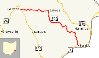
State Route 255 (SR 255) is an east–west state route located in southeast Ohio. Nestled entirely inside the southeast quadrant of Monroe County, the western terminus of State Route 255 is at a T-intersection with State Route 800 approximately 3 miles (4.8 km) south of Woodsfield. Its eastern terminus is at State Route 7 in the hamlet of Sardis, which is situated along the banks of the Ohio River.
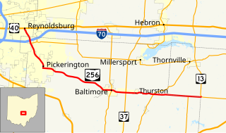
State Route 256 (SR 256) is a 25.99-mile (41.83 km) east–west state highway in the central portion of the U.S. state of Ohio. The western terminus of SR 256 is at a T-intersection with U.S. Route 40 (US 40) in Reynoldsburg. Its eastern terminus is at a T-intersection with SR 13 approximately 5.50 miles (8.85 km) west-northwest of Somerset.

State Route 219 is an east–west state highway in the western portion of the U.S. state of Ohio. State Route 219's western terminus is at the Indiana State Line approximately 5.5 miles (8.9 km) northwest of Fort Recovery, with the roadway continuing west into the Hoosier State being County Road 300N. The eastern terminus of State Route 219 is at a diamond interchange with Interstate 75 at its Exit 104 in Botkins.