Ohio State Route 288

Last updated

OH-288.svg

State Route 288
OH 288 map.svg
Route information
Maintained by ODOT
Length 6.82 mi [1] (10.98 km)
Existed 1953 – present
Major junctions
West endOH-309.svg SR 309 near Galion
East endOH-97.svg SR 97 near Lexington
Location
Counties Morrow
Highway system
OH-287.svg SR 287 SR 289 OH-289.svg

State Route 288 (SR 288) is a 6.82-mile (10.98 km) long eastwest state highway in the northern portion of the U.S. state of Ohio. The western terminus of SR 288 is at a T-intersection with SR 309 about 3 miles (4.8 km) southwest of Galion. Its eastern terminus is also at a T-intersection, this time with SR 97 approximately 5.50 miles (8.85 km) northwest of Lexington.

A state highway, state road, or state route is usually a road that is either numbered or maintained by a sub-national state or province. A road numbered by a state or province falls below numbered national highways in the hierarchy. Roads maintained by a state or province include both nationally numbered highways and un-numbered state highways. Depending on the state, "state highway" may be used for one meaning and "state road" or "state route" for the other.

U.S. state constituent political entity of the United States

In the United States, a state is a constituent political entity, of which there are currently 50. Bound together in a political union, each state holds governmental jurisdiction over a separate and defined geographic territory and shares its sovereignty with the federal government. Due to this shared sovereignty, Americans are citizens both of the federal republic and of the state in which they reside. State citizenship and residency are flexible, and no government approval is required to move between states, except for persons restricted by certain types of court orders. Four states use the term commonwealth rather than state in their full official names.

Ohio State of the United States of America

Ohio is a Midwestern state in the Great Lakes region of the United States. Of the fifty states, it is the 34th largest by area, the seventh most populous, and the tenth most densely populated. The state's capital and largest city is Columbus.

Contents

Route description

SR 288 just west of SR 97 in North Bloomfield Township SR 288 through North Bloomfield Township.jpg
SR 288 just west of SR 97 in North Bloomfield Township

SR 288 runs exclusively through the rural northern portion of Morrow County. The route begins at a T-intersection with SR 309 in Washington Township. It heads a short distance east and immediately intersects SR 61. SR 288 curves to the east-northeast just past this junction, bounded by farmland on the south side and woods on the north side. A few homes soon begin to appear alongside the roadway, as the land on the north side opens up prior to SR 288's crossing of the CSX railway. The highway soon crosses into North Bloomfield Township, where the rural setting features occasional patches of woods and a few homes amidst the predominant farmlands. SR 288 passes through successive intersections with Atkinson Road (County Road 38, CR 38) and West PointGalion Road (CR 40) prior to its junction with SR 19. Continuing to the east-northeast, SR 288 crosses Clase Road (Township Road 236, TR 236), WilliamsportCrestline Road (CR 46), North Bloomfield Road (TR 48), WilliamsportWilliamsburg Road (CR 20) and Meadowcreek Place (TR 249). SR 288 comes to an end as it arrives as the T-intersection it has with SR 97. [2]

Morrow County, Ohio County in the United States

Morrow County is a county located in the U.S. state of Ohio. As of the 2010 census, the population was 34,827. Its county seat is Mount Gilead. The county was organized in 1848 from parts of four neighboring counties and named for Jeremiah Morrow who was the Governor of Ohio from 1822 to 1826. Shawnee people used the area for hunting purposes before white settlers arrived in the early 19th century.

Washington Township, Morrow County, Ohio Township in Ohio, United States

Washington Township is one of the sixteen townships of Morrow County, Ohio, United States. The 2010 census found 1,300 people in the township.

Ohio State Route 61 highway in Ohio

State Route 61 is a north–south state highway in the northern portion of the U.S. state of Ohio. Its southern terminus is at the U.S. Route 36/State Route 3 concurrency in Sunbury, and its northern terminus is at U.S. Route 6 east of Huron, at the southernmost point of Lake Erie. State Route 61 is routed through the communities of Mount Gilead, Galion, Crestline, Shelby, Plymouth, Norwalk, and Berlin Heights.

No part of this highway is included within the National Highway System. [3]

National Highway System (United States) highway system in the United States

The National Highway System (NHS) is a network of strategic highways within the United States, including the Interstate Highway System and other roads serving major airports, ports, rail or truck terminals, railway stations, pipeline terminals and other strategic transport facilities. Altogether, it constitutes the largest highway system in the world.

History

The SR 288 designation was applied in 1953. This route has utilized the same alignment through northern Morrow County since it was first established. [4] [5]

An earlier SR 288 designation became SR 640 in 1941. [6] [7]

Ohio State Route 640 highway in Ohio

State Route 640 is an east–west state highway in the northeastern portion of the U.S. state of Ohio. SR 640 has its western terminus is at a signalized intersection with SR 283 in Willowick. Its eastern terminus is in downtown Willoughby at a signalized intersection where it meets US 20 and SR 174, the latter of which has its northern terminus at this same intersection.

Major intersections

The entire route is in Morrow County.

Locationmi [1] kmDestinationsNotes
Washington Township 0.000.00OH-309.svg SR 309  Marion, Galion
0.100.16OH-61.svg SR 61  Mount Gilead
North Bloomfield Township 3.064.92OH-19.svg SR 19
6.8210.98OH-97.svg SR 97  Galion, Lexington
1.000 mi = 1.609 km; 1.000 km = 0.621 mi

Related Research Articles

Ohio State Route 330 highway in Ohio

State Route 330 is a north–south state highway in the northwestern portion of the U.S. state of Ohio. The southern terminus of SR 330 is at a diamond interchange with the SR 15 expressway just south of the village limits of Vanlue. Its northern terminus is at SR 568 nearly 1.75 miles (2.82 km) north of Vanlue.

Ohio State Route 300 highway in Ohio

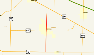
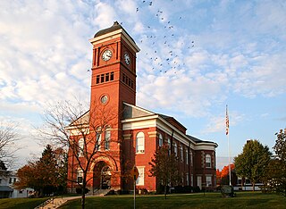
State Route 300 is a 6.33-mile (10.19 km) long north–south state highway in northwestern Ohio, a U.S. state. The southern terminus of SR 300 is at a T-intersection with U.S. Route 6 (US 6) approximately 1.50 miles (2.41 km) west of the village of Helena. Its northern terminus is at US 20 just over 2.50 miles (4.02 km) southeast of Woodville.

Ohio State Route 701 highway in Ohio

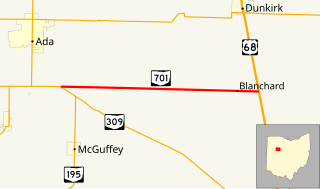
State Route 701 is a 8.96-mile (14.42 km) east–west state highway in western Ohio, a U.S. state. The state highway's western terminus is at a T-intersection with SR 309 nearly 3 miles (4.8 km) southeast of Ada. The eastern terminus of State Route 701 is at U.S. Route 68 (US 68) approximately 3.50 miles (5.63 km) southeast of Dunkirk.

Ohio State Route 368 highway in Ohio

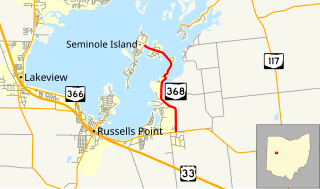
State Route 368 is a short north–south state highway in western Ohio, a U.S. state. SR 368 travels from its southern terminus at SR 366 approximately 1.75 miles (2.82 km) east of Russells Point to its northern terminus on Seminole Island in the eastern half of Indian Lake, at an intersection where it meets Logan County Road 272 (CR 272) and CR 286. Having made its debut in the late 1930s, SR 368 is a two-lane spur route that serves both Indian Lake State Park and communities of cottages that are on two eastern Indian Lake islands: Shawnee and Seminole.

Ohio State Route 287 highway in Ohio

State Route 287 (SR 287) is a 13.69-mile-long (22.03 km) east–west state highway in the western portion of the U.S. state of Ohio. The western terminus of SR 287 is at SR 245 nearly 1.75 miles (2.82 km) east of West Liberty. Its eastern terminus is at an interchange with U.S. Route 33 (US 33) about 5.25 miles (8.45 km) northeast of North Lewisburg that dually serves as the southern terminus of SR 739.

Ohio State Route 797 highway in Ohio

State Route 797 was a very short, unsigned north–south state highway in the eastern portion of the U.S. state of Ohio. At the time of its deletion of the route from the state highway system, SR 797 ran from its southern terminus at the U.S. Route 22/U.S. Route 40 concurrency about 4.75 miles (7.64 km) northeast of Zanesville to its northern terminus less than 0.40 miles (0.64 km) to the northwest at Interstate 70 at its exit 160, a diamond interchange. North of the interchange, the road continues to Sonora on Muskingum County Road 52, Sonora Road.

Ohio State Route 609 highway in Ohio

State Route 609 (SR 609) is a 2.65-mile (4.26 km) long east–west state highway in the northeastern portion of the U.S. state of Ohio. The highway runs from its western terminus at a T-intersection SR 7 approximately 2 miles (3.2 km) west of the village of Orangeville to its eastern terminus at the Pennsylvania State line in Orangeville, where SR 609 meets a county-maintained road that straddles the border, Brockway–Sharon Road, at a T-intersection.

Ohio State Route 621 highway in Ohio

State Route 621 is a north–south state highway in the central part of the U.S. state of Ohio. The southern terminus of SR 621 is at U.S. Route 36 approximately two and a half miles (4.0 km) northeast of Coshocton, and its northern terminus is adjacent to the North Appalachian Experimental Watershed Station, just north of its intersection with White Eyes Township Road 188, about 5 miles (8.0 km) northwest of the hamlet of Fresno. Continuing north after SR 621 ends is County Road 190.

Ohio State Route 500 highway in Ohio

State Route 500 (SR 500) is a 13.32-mile-long (21.44 km) Ohio State Route that runs between the Indiana state line and Paulding in the US state of Ohio. None of the highway is listed on the National Highway System. Most of the route is a rural two-lane highway and passes through both farmland and residential properties. For much of its path, SR 500 runs generally parallel to the north of Flatrock Creek.

Ohio State Route 383 highway in Ohio

State Route 383 (SR 383) is a 1.50-mile-long (2.41 km) north south state highway in the central portion of the U.S. state of Ohio. The highway is a spur route whose southern terminus is at the entrance to Ohio's oldest Catholic Church, Saint Joseph's, nearly two miles (3.2 km) southeast of Somerset. County Road 60 picks up where SR 383 leaves off heading southeast from the church entrance. The northern terminus of SR 383 is at a T-intersection with SR 13 just 0.50 miles (0.80 km) east of the village limits of Somerset.

Ohio State Route 314 highway in Ohio

State Route 314 (SR 314) is a north–south state highway in the northern portion of the U.S. state of Ohio. The southern terminus of SR 314 is at a T-intersection with the duplex of U.S. Route 36 (US 36) and SR 3 in Centerburg. Its northern terminus is at a T-intersection with State Route 61 less than 1 mile (1.6 km) south of the city limits of Shelby.

Ohio State Route 152 highway in Ohio

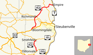
State Route 152 is the designation for two segments of a state highway in Jefferson County, Ohio. The southern segment, which is 6.18 miles (9.95 km) long, runs from SR 150 in Dillonvale to SR 151 in Smithfield. The northern segment, which is 20.20 miles (32.51 km) long, runs from an interchange with U.S. Route 22 (US 22) in Bloomingdale to SR 7 in Empire.

Ohio State Route 746 highway in Ohio

State Route 746 is a north–south thirteen-mile-long (21 km) state highway located in central Ohio, a U.S. state. Its southern terminus is at U.S. Route 42 (US 42) approximately three miles (4.8 km) north of Ashley, and its northern terminus is at SR 309 in Caledonia.

Ohio State Route 799 highway in Ohio

State Route 799 is an east–west state highway located in the eastern portion of the U.S. state of Ohio. The highway runs from its western terminus at a T-intersection with SR 800 approximately 1.25 miles (2.01 km) northeast of Freeport to its eastern terminus at its intersection with Redeye Road about three miles (4.8 km) south of Deersville. Continuing north from SR 799's eastern terminus is Mallarnee Road (CR 21).

Ohio State Route 320 highway in Ohio

State Route 320 (SR 320) is a short north–south state highway in western Ohio, a U.S. state. The southern terminus of SR 320 is at U.S. Route 35 (US 35) approximately three miles (4.8 km) southeast of New Paris, 34 mile (1.2 km) south of US 35's eastern junction with Interstate 70 (I-70). The northern terminus of the state highway is located in New Paris at a signalized intersection with SR 121.

Ohio State Route 138 highway in Ohio

State Route 138 is an east–west state highway in the southwestern portion of the U.S. state of Ohio. Its west terminus is at its intersection with SR 134 in Buford and its eastern terminus is at its intersection with US 22 east of Williamsport.

Ohio State Route 557 highway in Ohio

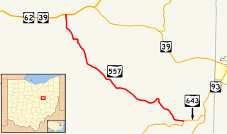
State Route 557 is a two-lane north–south state highway in the central portion of Ohio, a U.S. state. The highway's southern terminus is at a T-intersection with State Route 643 approximately 2 miles (3.2 km) north of Baltic. Its northern terminus is at a T-intersection with the concurrency of U.S. Route 62 and State Route 39 nearly 1.5 miles (2.4 km) west of the unincorporated community of Berlin.

Ohio State Route 565 highway in Ohio

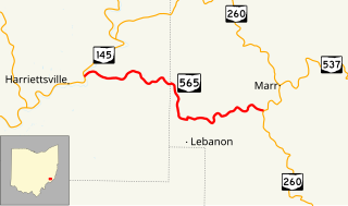
State Route 565 (SR 565) is a 6.98-mile-long (11.23 km) east–west state highway in the southeastern portion of the U.S. state of Ohio. The western terminus of SR 565 is at a T-intersection with SR 145 nearly 8 miles (13 km) northeast of the village of Lower Salem. Its eastern terminus is also at a T-intersection, this time at SR 260 approximately 7.25 miles (11.67 km) southwest of Graysville.

Ohio State Route 316

State Route 316 is a 14.05-mile (22.61 km) long state highway located in Pickaway County, Ohio. The east–west route runs from SR 56 in the Five Points section of Monroe Township to SR 752 in Ashville.

Ohio State Route 771

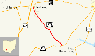
State Route 771 is a 7.11-mile-long (11.44 km) state highway located entirely in Highland County, Ohio. The north–south route connects SR 138 in Paint Township and SR 28 in Leesburg.

References

  1. 1 2 "DESTAPE - Morrow County" (PDF). Ohio Department of Transportation. June 24, 2015. Retrieved November 14, 2015.
  2. Google (November 14, 2015). "Overview Map of State Route 288" (Map). Google Maps . Google. Retrieved November 14, 2015.
  3. National Highway System: Ohio (PDF) (Map). Federal Highway Administration. December 2003. Retrieved 2010-11-26.
  4. Ohio Highway Map (MrSID) (Map). Cartography by ODOH. Ohio Department of Highways. 1951. Retrieved 2010-12-02.
  5. Ohio Highway Map (MrSID) (Map). Cartography by ODOH. Ohio Department of Highways. 1953. Retrieved 2010-12-02.
  6. Ohio State Map (Map). Ohio Department of Transportation. 1940.
  7. Ohio State Map (Map). Ohio Department of Transportation. 1941.

Route map: Google

KML file (edithelp)
KML is from Wikidata