State Route 532 is a north–south state highway in the northeastern portion of the U.S. state of Ohio. The highway runs from its southern terminus at a signalized intersection with U.S. Route 224 (US 224) on the Summit–Portage county line approximately 0.75 miles (1.21 km) south of Mogadore on the border of Springfield Township and Suffield Township to its northern terminus at a diamond interchange with Interstate 76 (I-76), at its exit 29 within the Tallmadge city limits.

State Route 633 is a short north–south state highway in the northeastern portion of the U.S. state of Ohio. Occupying a portion of Lloyd Road, SR 633 has its southern terminus at a signalized intersection with U.S. Route 20 (US 20) in Wickliffe. Its northern terminus is also in Wickliffe, but at a signalized intersection with Lakeland Boulevard, which provides access to current SR 2 freeway by way of a trumpet interchange just to the east.

State Route 708 (SR 708) is a short two-lane north–south state route that runs exclusively within Logan County, Ohio. The southern terminus of SR 708 approximately two miles (3.2 km) south of Russells Point at SR 235, near the Russells Point Honda manufacturing facility, and its northern terminus is just north of Russells Point at Indian Lake State Park, where the highway becomes Township Road 253 on Orchard Island.
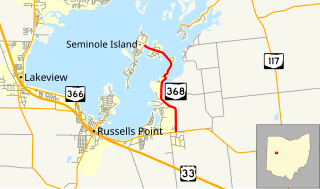
State Route 368 is a short north–south state highway in western Ohio, a U.S. state. SR 368 travels from its southern terminus at SR 366 approximately 1.75 miles (2.82 km) east of Russells Point to its northern terminus on Seminole Island in the eastern half of Indian Lake, at an intersection where it meets Logan County Road 272 (CR 272) and CR 286. Having made its debut in the late 1930s, SR 368 is a two-lane spur route that serves both Indian Lake State Park and communities of cottages that are on two eastern Indian Lake islands: Shawnee and Seminole.

State Route 373 is north–south state highway in the southern portion of Ohio. Its southern terminus is just over eleven miles (18 km) north of Ironton at SR 93 at the hamlet of Bartles, and its northern terminus is at about three miles (4.8 km) to the north of its southern terminus, also at SR 93.
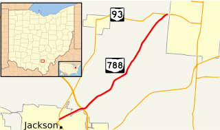
State Route 788 is a north–south state highway in the southern portion of the U.S. state of Ohio. The western terminus is at State Route 93 in Jackson. Its eastern terminus is also at State Route 93, this time less than 2 miles (3.2 km) west of Wellston.
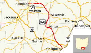
State Route 160 is a north–south state highway in the southeastern portion of the U.S. state of Ohio. Its southern terminus is at SR 7 in Gallipolis, and the route heads north. It meets U.S. Route 35 at an interchange with various collector and distributor ramps. SR 160 southbound bypasses the interchange on a 0.739-mile-long (1.189 km) road officially designated SR 160-A. From there, the route passes through Vinton in northern Gallia County. Following an intersection with SR 32, the route heads in a more westerly direction until it meets and its northern terminus is at State Route 93 in Hamden.

State Route 324 (SR 324) is a north–south state highway in the southern portion of the U.S. state of Ohio. The southern terminus of SR 324 is at a T-intersection with SR 160 about 4.50 miles (7.24 km) east of Hamden. Its northern terminus is at SR 93 nearly 4 miles (6.4 km) northeast of Hamden.
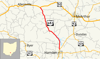
State Route 683 is a north–south state highway in the southern portion of the U.S. state of Ohio. The southern terminus of State Route 683 is at a T-intersection with State Route 93 about 0.50 miles (0.80 km) north of Hamden. Its northern terminus is also at a T-intersection, this time with U.S. Route 50 nearly 6 miles (9.7 km) west of McArthur.

State Route 671 is an east-west state highway in the southern portion of Ohio. Existing entirely within Vinton County, the western terminus of this short connector route is at SR 327 three miles (4.8 km) northeast of the hamlet of Londonderry. Its eastern terminus is at U.S. Route 50 (US 50) in the unincorporated community of Ratcliffburg.

State Route 601 is a north–south state highway in North Central Ohio. A two-lane eastern bypass of Norwalk, SR 601 has its southern terminus at SR 18 southeast of Norwalk, adjacent to Summit Motorsports Park. The northern terminus of SR 601 is at SR 113 in downtown Milan, less than one-quarter mile (0.40 km) east of the junction of SR 113 and the U.S. Route 250 (US 250)/SR 13 concurrency.
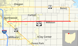
State Route 579 is an east–west state highway in northwestern Ohio, a U.S. state. The western terminus of SR 579 is at SR 51 just south of the city limits of Northwood. Its eastern terminus is at a T-intersection with SR 2 approximately four miles (6.4 km) to the east of Williston.
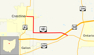
State Route 181 (SR 181) is a 4.46-mile (7.18 km) long east–west state highway in the northern portion of the U.S. state of Ohio. The western terminus of SR 181 is at a signalized intersection with SR 61 in downtown Crestline, and its eastern terminus is at a T-intersection with SR 309 approximately one mile (1.6 km) west of Ontario.
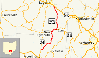
State Route 328 (SR 328) is a north–south state highway in the southeastern quadrant of the U.S. state of Ohio. The southern terminus of SR 328 is at SR 93 approximately 2.75 miles (4.43 km) north of McArthur. Its northern terminus is at a diamond interchange with U.S. Route 33 (US 33) in the extreme southeastern portion of Logan, immediately northeast of where it crosses over the Hocking River.

State Route 278 is a north–south state highway located in the southeastern part of the U.S. state of Ohio. The southern terminus of SR 278 is at US 50 approximately 4.75 miles (7.64 km) east of McArthur. The highway's northern terminus is at the T-intersection it has with SR 595 nearly 5.50 miles (8.85 km) northwest of Nelsonville.

State Route 282 is a north–south state highway in northeastern Ohio, a U.S. state. The southern terminus of SR 282 is at a T-intersection with SR 305 near the hamlet of Nelson. Its northern terminus is also at a T-intersection, this time with the four-lane divided U.S. Route 422 (US 422) approximately two miles (3.2 km) southeast of Parkman. SR 282 primarily serves as an access route for Nelson Kennedy Ledges State Park. For its duration, the highway is also known as Nelson Ledge Road.

State Route 191 is a north–south state highway in northwestern Ohio, a U.S. state. SR 191's southern terminus is at U.S. Route 6 (US 6) approximately four miles (6.4 km) south of Stryker. Its northern terminus is at the concurrency of US 20A and US 127 in downtown West Unity. Between its southern terminus and Stryker, SR 191 runs parallel to, and to the east of, the Tiffin River.

State Route 363 is a short north–south state highway located in west-central Ohio. The southern terminus of this spur route is along the shores of Lake Loramie approximately two and a half miles (4.0 km) southeast of Minster, where the roadway becomes known as Lotus Road. The northern terminus of SR 363 is at a T-intersection with SR 119 about one mile (1.6 km) east of Minster.
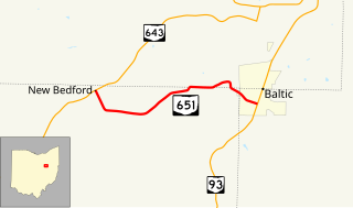
State Route 651 is a short state highway located in the vicinity of the tripoint of Coshocton, Holmes, and Tuscarawas Counties in Ohio. The route is 3.98 miles (6.41 km) long and is signed east–west. Its western terminus is at SR 643 in the unincorporated community of New Bedford and its eastern terminus is at SR 93 in the village of Baltic.