
State Route 330 is a north–south state highway in the northwestern portion of the U.S. state of Ohio. The southern terminus of SR 330 is at a diamond interchange with the SR 15 expressway just south of the village limits of Vanlue. Its northern terminus is at SR 568 nearly 1.75 miles (2.82 km) north of Vanlue.
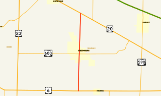
State Route 300 is a 6.33-mile (10.19 km) long north–south state highway in northwestern Ohio, a U.S. state. The southern terminus of SR 300 is at a T-intersection with U.S. Route 6 (US 6) approximately 1.50 miles (2.41 km) west of the village of Helena. Its northern terminus is at US 20 just over 2.50 miles (4.02 km) southeast of Woodville.
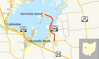
State Route 368 is a short north–south state highway in western Ohio, a U.S. state. SR 368 travels from its southern terminus at SR 366 approximately 1.75 miles (2.82 km) east of Russells Point to its northern terminus on Seminole Island in the eastern half of Indian Lake, at an intersection where it meets Logan County Road 272 (CR 272) and CR 286. Having made its debut in the late 1930s, SR 368 is a two-lane spur route that serves both Indian Lake State Park and communities of cottages that are on two eastern Indian Lake islands: Shawnee and Seminole.

State Route 540 (SR 540) is an east–west state highway in the western portion of the U.S. state of Ohio. SR 540 has its western terminus in downtown Bellefontaine at a signalized intersection with U.S. Route 68 (US 68) and SR 47. Its eastern terminus is at a T-intersection with SR 292 approximately 3.50 miles (5.63 km) southwest of West Mansfield.

State Route 797 was a very short, unsigned north–south state highway in the eastern portion of the U.S. state of Ohio. At the time of its deletion of the route from the state highway system, SR 797 ran from its southern terminus at the U.S. Route 22/U.S. Route 40 concurrency about 4.75 miles (7.64 km) northeast of Zanesville to its northern terminus less than 0.40 miles (0.64 km) to the northwest at Interstate 70 at its exit 160, a diamond interchange. North of the interchange, the road continues to Sonora on Muskingum County Road 52, Sonora Road.

State Route 372 (SR 372) is a very short, two-lane east–west state highway in the southern part of the U.S. state of Ohio. The western terminus of this spur route is at a T-intersection with the concurrency of U.S. Route 23 (US 23) and SR 104 about six and a half miles (10.5 km) north of Waverly. Its eastern terminus is just 0.68 miles (1.09 km) to the east of that point at the boundary of Scioto Trail State Forest. Continuing east of that point is Stoney Creek Road, which traverses through the state forest in the direction of the Scioto River. From its inception in the middle of the 1930s, the primary function of SR 372 has been to provide access to the state forest from the state highway system.

State Route 621 is a north–south state highway in the central part of the U.S. state of Ohio. The southern terminus of SR 621 is at U.S. Route 36 approximately two and a half miles (4.0 km) northeast of Coshocton, and its northern terminus is adjacent to the North Appalachian Experimental Watershed Station, just north of its intersection with White Eyes Township Road 188, about 5 miles (8.0 km) northwest of the hamlet of Fresno. Continuing north after SR 621 ends is County Road 190.

State Route 370 (SR 370) is 1.21-mile (1.95 km) long north–south state highway in the western part of the U.S. state of Ohio. The highway runs from its southern terminus at the main entrance to John Bryan State Park nearly two miles (3.2 km) southeast of Yellow Springs to its northern terminus at SR 343 about 0.75 miles (1.21 km) east of Yellow Springs.
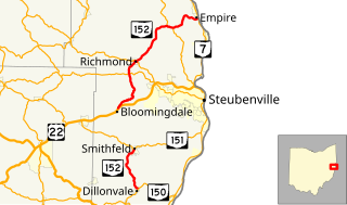
State Route 152 is the designation for two segments of a state highway in Jefferson County, Ohio. The southern segment, which is 6.18 miles (9.95 km) long, runs from SR 150 in Dillonvale to SR 151 in Smithfield. The northern segment, which is 20.20 miles (32.51 km) long, runs from an interchange with U.S. Route 22 (US 22) in Bloomingdale to SR 7 in Empire.
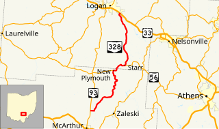
State Route 328 (SR 328) is a north–south state highway in the southeastern quadrant of the U.S. state of Ohio. The southern terminus of SR 328 is at SR 93 approximately 2.75 miles (4.43 km) north of McArthur. Its northern terminus is at a diamond interchange with U.S. Route 33 (US 33) in the extreme southeastern portion of Logan, immediately northeast of where it crosses over the Hocking River.
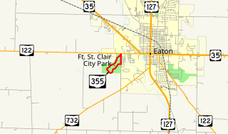
State Route 355 was a short 1.37-mile-long (2.20 km) state highway in southwestern Ohio. The route served the former Fort St. Clair State Memorial in Eaton, Preble County. The route began at SR 122 in western Eaton, traveled south along Camden Road for about 0.3 miles (0.48 km) before turning into the memorial, looping through the entire site, and ending at itself just south of the route's start at SR 122. The route was removed from the state highway system shortly after the park's jurisdiction was transferred from the state to the City of Eaton.

State Route 339 (SR 339) is a north–south state highway in southeastern Ohio, a U.S. state. The southern terminus of SR 339 is at SR 618 approximately 2 miles (3.2 km) west of Belpre, and less than 0.50 miles (0.80 km) south of the U.S. Route 50 (US 50)/SR 7/SR 32 expressway. The highway's northern terminus is a T-intersection with SR 821 about 0.75 miles (1.21 km) south of Dexter City.

State Route 799 is an east–west state highway located in the eastern portion of the U.S. state of Ohio. The highway runs from its western terminus at a T-intersection with SR 800 approximately 1.25 miles (2.01 km) northeast of Freeport to its eastern terminus at its intersection with Redeye Road about three miles (4.8 km) south of Deersville. Continuing north from SR 799's eastern terminus is Mallarnee Road (CR 21).

State Route 676 (SR 676) is a 26.53-mile (42.70 km) long east–west state highway in the southeastern portion of the U.S. state of Ohio. The western terminus of SR 676 is at a T-intersection with SR 555 approximately 3 miles (4.8 km) southeast of the village of Chesterhill. Its eastern terminus is at a T-intersection with SR 7 in the southwestern portion of the city of Marietta.

State Route 185 (SR 185) is a 21.70-mile (34.92 km) long east–west state highway in the western part of the U.S. state of Ohio. The western terminus of SR 185 is at U.S. Route 127 (US 127) approximately 3.75 miles (6.04 km) south of North Star. Its eastern terminus is in Piqua. Until 2011, this was at its junction with US 36 and SR 66 in the city's downtown business district, at the intersection of Ash Street and Spring Street. In 2011, SR 185 was re-routed to travel south along Sunset Drive in the western part of Piqua to a new eastern terminus where Sunset Drive meets US 36, which is known as Covington Avenue at that location.

State Route 122 is an Ohio state highway which runs from the Ohio-Indiana state line in Preble County east of Eaton, Ohio to SR 48 near Lebanon, Ohio, a distance of 43.4 miles (69.8 km). When the route was designated in 1923, it ran along its current route from Indiana to Middletown. It was extended to its current eastern terminus in 1937 but was extended further east to U.S. Route 42 in 1946. The route was truncated back to SR 48 by 1985 with the former section being renamed "Old State Route 122" and maintained by Warren County as CR 230. The route also used to continue west of the Indiana state line as Indiana State Road 122 west to its terminus at US 27 east of Abington, Indiana.

State Route 358 (SR 358) is a 0.92-mile-long (1.48 km) north–south state highway in the northern portion of the U.S. state of Ohio. The southern terminus of SR 358 is at a T-intersection with SR 163 nearly 5.75 miles (9.25 km) east of Oak Harbor, just north of the Portage River. Its northern terminus is at SR 2 at an intersection just outside Camp Perry about three and a half miles (5.6 km) west of Port Clinton.
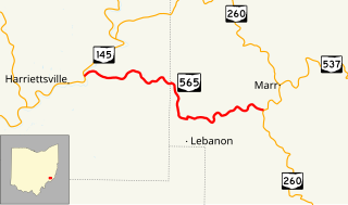
State Route 565 (SR 565) is a 6.98-mile-long (11.23 km) east–west state highway in the southeastern portion of the U.S. state of Ohio. The western terminus of SR 565 is at a T-intersection with SR 145 nearly 8 miles (13 km) northeast of the village of Lower Salem. Its eastern terminus is also at a T-intersection, this time at SR 260 approximately 7.25 miles (11.67 km) southwest of Graysville.

State Route 668 is a north-south state highway in central Ohio. Its southern terminus is at an intersection with SR 93 in the Wayne National Forest, northeast of Logan; its northern terminus is at an intersection with US 40 in the unincorporated community of Brownsville.


