State Route 12 is a generally northeast-southwest route in Ohio. Its western terminus is at SR 115 and SR 189 in Vaughnsville, and its eastern terminus is at SR 53 just south of Fremont.
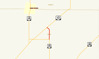
State Route 228 (SR 228) is a short north–south state highway in the U.S. state of Ohio. The southern terminus of the state route is at State Route 19 (SR 19) nearly five and a half miles (8.9 km) north of Republic. Its northern terminus is at SR 101 approximately 5.5 miles (8.9 km) southwest of Clyde.
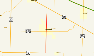
State Route 300 is a 6.33-mile (10.19 km) long north–south state highway in northwestern Ohio, a U.S. state. The southern terminus of SR 300 is at a T-intersection with U.S. Route 6 (US 6) approximately 1.50 miles (2.41 km) west of the village of Helena. Its northern terminus is at US 20 just over 2.50 miles (4.02 km) southeast of Woodville.
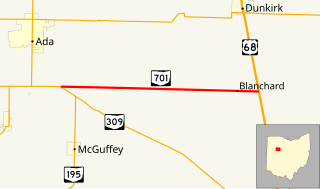
State Route 701 is a 8.96-mile (14.42 km) east–west state highway in western Ohio, a U.S. state. The state highway's western terminus is at a T-intersection with SR 309 nearly 3 miles (4.8 km) southeast of Ada. The eastern terminus of State Route 701 is at U.S. Route 68 (US 68) approximately 3.50 miles (5.63 km) southeast of Dunkirk.
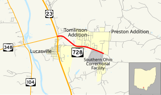
State Route 728 is a short east–west state highway situated in south-central Ohio. At a length of just under 2 miles (3.2 km), the state highway is a spur route that provides access to the Southern Ohio Correctional Facility. The western terminus of SR 728 is at a signalized intersection with U.S. Route 23 (US 23) in Lucasville that doubles as the eastern terminus of SR 348. Its eastern terminus is just east of the Southern Ohio Correctional Facility, at the intersection of Lucasville-Minford Road and Lang Lane (CR 180).

State Route 638 is a two-lane north–south state highway in the west central portion of Ohio, a U.S. state. SR 638 has its southern terminus at an intersection with U.S. Route 68 (US 68) just over six miles (9.7 km) north of the city of Bellefontaine. The northern terminus of the route is at SR 273 at the extreme southeastern corner of the village of Belle Center.

State Route 708 (SR 708) is a short two-lane north–south state route that runs exclusively within Logan County, Ohio. The southern terminus of SR 708 approximately two miles (3.2 km) south of Russells Point at SR 235, near the Russells Point Honda manufacturing facility, and its northern terminus is just north of Russells Point at Indian Lake State Park, where the highway becomes Township Road 253 on Orchard Island.
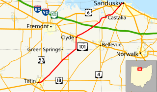
State Route 101 (SR 101) is a southwest-northeast state highway in the north central portion of the U.S. state of Ohio. Its western terminus is at the junction of SR 18 and SR 53 in Tiffin; it runs concurrently with SR 18 for about one mile (1.6 km). Its eastern terminus is at the junction of U.S. Route 6 (US 6) and SR 4 in Sandusky; it runs concurrently with US 6 for just over one and a half miles (2.4 km) to its western terminus.

State Route 293 (SR 293) is a 6.277-mile-long (10.102 km) north–south state highway in the northwestern portion of the U.S. state of Ohio. The southern terminus of SR 293 is at SR 53 nearly one-half mile (0.80 km) south of the village limits of Kirby. Its northern terminus is at the intersection of Sandusky Street and Cass Street in Wharton. The route was designated in 1932, and was extended south in 1997.

State Route 621 is a north–south state highway in the central part of the U.S. state of Ohio. The southern terminus of SR 621 is at U.S. Route 36 approximately two and a half miles (4.0 km) northeast of Coshocton, and its northern terminus is adjacent to the North Appalachian Experimental Watershed Station, just north of its intersection with White Eyes Township Road 188, about 5 miles (8.0 km) northwest of the hamlet of Fresno. Continuing north after SR 621 ends is County Road 190.

State Route 745 (SR 745) is a state route in central Ohio that runs in a north-northwesterly direction along the west bank of the Scioto River. Its southern terminus is at the concurrency of U.S. Route 33 (US 33) and SR 161 in Dublin, and it runs for approximately ten miles (16 km) to Concord Township in Delaware County, where it arrives at its northern terminus at the concurrency of US 42 and SR 257. SR 745 was designated in 1937, and its routing has not changed since.

State Route 768 is a 1.7-mile (2.7 km) long north–south state highway in the central portion of the U.S. state of Ohio. The highway runs from its southern terminus at a signalized intersection with U.S. Route 36 (US 36) in the eastern portion of the city of Mount Vernon to its northern terminus at SR 3 approximately 1.25 miles (2.01 km) north of the Mount Vernon city limits.

State Route 506 (SR 506) is an east–west state route in southern Ohio. Existing entirely in eastern Highland County, SR 506 has its western terminus at SR 124 in the hamlet of Marshall. Its eastern terminus is at SR 753 in another unincorporated community, Carmel.
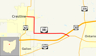
State Route 181 (SR 181) is a 4.46-mile (7.18 km) long east–west state highway in the northern portion of the U.S. state of Ohio. The western terminus of SR 181 is at a signalized intersection with SR 61 in downtown Crestline, and its eastern terminus is at a T-intersection with SR 309 approximately one mile (1.6 km) west of Ontario.

State Route 521 is an east–west state highway in central Ohio. Existing entirely within Delaware County, the western terminus of SR 521 is at SR 37 in Delaware. Its eastern terminus is at SR 656 in the hamlet of Olive Green, located approximately five miles (8.0 km) north of Sunbury.

State Route 746 is a north–south thirteen-mile-long (21 km) state highway located in central Ohio, a U.S. state. Its southern terminus is at U.S. Route 42 (US 42) approximately three miles (4.8 km) north of Ashley, and its northern terminus is at SR 309 in Caledonia.
State Route 136 (SR 136) is a 6.151-mile (9.899 km) state highway in Monroe County in the southwestern part of the U.S. state of Alabama. The western terminus of the highway is at an intersection with SR 21 south of Monroeville. The eastern terminus of the route is at an intersection with U.S. Route 84 and SR 41 near the Monroe–Conecuh county line, at a point east of Excel.
State Route 104 (SR 104) is a 10.769-mile-long (17.331 km) state highway completely within Baldwin County in the southwestern part of the U.S. state of Alabama. The western terminus of the highway is at an intersection with U.S. Route 98 (US 98) in Fairhope. The eastern terminus of the highway is at an intersection with SR 59 in Robertsdale.

State Route 135 (SR 135) is a short north–south state highway in the southwestern portion of the U.S. state of Ohio. SR 135 travels from its southern terminus at a T-intersection with U.S. Route 50 (US 50) approximately two miles (3.2 km) south of the village of Lynchburg to its northern terminus in Lynchburg at a T-intersection with SR 134.

State Route 644 is a north–south state highway running through Columbiana and Carroll counties in northeast Ohio. Its southern terminus is at SR 39 in downtown Salineville, and its northern terminus is at its junction with U.S. Route 30(US 30) and SR 9 in the center of Kensington. The route connects mainly rural and a few unincorporated parts of southeastern Columbiana County. SR 644 only briefly passes into a corner of Carroll County for a 0.41-mile (0.66 km) journey.