State Route 532 is a north–south state highway in the northeastern portion of the U.S. state of Ohio. The highway runs from its southern terminus at a signalized intersection with U.S. Route 224 (US 224) on the Summit–Portage county line approximately 0.75 miles (1.21 km) south of Mogadore on the border of Springfield Township and Suffield Township to its northern terminus at a diamond interchange with Interstate 76 (I-76), at its exit 29 within the Tallmadge city limits.

State Route 253 is a very short east–west state highway in the southern part of the U.S. state of Ohio. With an overall length of just 0.56 miles (0.90 km), the majority of SR 253 is a part of the Jesse Stuart Memorial Bridge, which crosses over the Ohio River near Franklin Furnace, Ohio. The western terminus of SR 253 is at about the midspan of the bridge, where it crosses the Kentucky State Line and becomes Kentucky Route 10 (KY 10). The eastern terminus of the highway is at a diamond interchange with U.S. Route 52 (US 52) near the eastern landing of the Ohio River crossing. The current SR 253 was established in the late 1980s. However, an earlier version of the highway existed in the Medina vicinity from the early 1920s until the late 1950s.
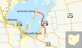
State Route 368 is a short north–south state highway in western Ohio, a U.S. state. SR 368 travels from its southern terminus at SR 366 approximately 1.75 miles (2.82 km) east of Russells Point to its northern terminus on Seminole Island in the eastern half of Indian Lake, at an intersection where it meets Logan County Road 272 (CR 272) and CR 286. Having made its debut in the late 1930s, SR 368 is a two-lane spur route that serves both Indian Lake State Park and communities of cottages that are on two eastern Indian Lake islands: Shawnee and Seminole.

State Route 287 (SR 287) is a 13.69-mile-long (22.03 km) east–west state highway in the western portion of the U.S. state of Ohio. The western terminus of SR 287 is at SR 245 nearly 1.75 miles (2.82 km) east of West Liberty. Its eastern terminus is at an interchange with U.S. Route 33 (US 33) about 5.25 miles (8.45 km) northeast of North Lewisburg that dually serves as the southern terminus of SR 739.

State Route 609 (SR 609) is a 2.65-mile (4.26 km) long east–west state highway in the northeastern portion of the U.S. state of Ohio. The highway runs from its western terminus at a T-intersection SR 7 approximately 2 miles (3.2 km) west of the village of Orangeville to its eastern terminus at the Pennsylvania State line in Orangeville, where SR 609 meets a county-maintained road that straddles the border, Brockway–Sharon Road, at a T-intersection.

State Route 621 is a north–south state highway in the central part of the U.S. state of Ohio. The southern terminus of SR 621 is at U.S. Route 36 approximately two and a half miles (4.0 km) northeast of Coshocton, and its northern terminus is adjacent to the North Appalachian Experimental Watershed Station, just north of its intersection with White Eyes Township Road 188, about 5 miles (8.0 km) northwest of the hamlet of Fresno. Continuing north after SR 621 ends is County Road 190.
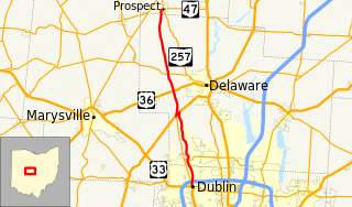
State Route 257 is a 26.19-mile (42.15 km) north - south state highway in the central portion of the U.S. state of Ohio. The highway's southern terminus is in the northwestern Columbus suburb of Dublin at a roundabout intersection with U.S. Route 33 and SR 161. This mainly two-lane highway follows the eastern side of the Scioto River from Dublin to its junction with US 42. After crossing over the river with the U.S. highway, SR 257 parallels the river's western bank. SR 257 has its northern terminus at a T-intersection with SR 47 on the western village limits of Prospect. SR 257 was created in 1926, and extended in 1935 and 1937.

State Route 500 (SR 500) is a 13.32-mile-long (21.44 km) Ohio State Route that runs between the Indiana state line and Paulding in the US state of Ohio. None of the highway is listed on the National Highway System. Most of the route is a rural two-lane highway and passes through both farmland and residential properties. For much of its path, SR 500 runs generally parallel to the north of Flatrock Creek.

State Route 383 (SR 383) is a 1.50-mile-long (2.41 km) north south state highway in the central portion of the U.S. state of Ohio. The highway is a spur route whose southern terminus is at the entrance to Ohio's oldest Catholic Church, Saint Joseph's, nearly two miles (3.2 km) southeast of Somerset. County Road 60 picks up where SR 383 leaves off heading southeast from the church entrance. The northern terminus of SR 383 is at a T-intersection with SR 13 just 0.50 miles (0.80 km) east of the village limits of Somerset.

State Route 305 is a 33.99-mile (54.70 km) long east–west state highway in the northeastern portion of the U.S. state of Ohio. The western terminus of SR 305 is at a signalized intersection with the duplex of SR 82 and SR 700 in the village of Hiram. Its eastern terminus is at a five-way stop intersection on the Pennsylvania state line nearly 1.75 miles (2.82 km) south of Orangeville. Picking up where SR 305 leaves off heading southeast into Pennsylvania from this intersection is PA 718.
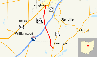
State Route 546 is a north–south state highway in the northern portion of the U.S. state of Ohio. The southern terminus of SR 546 is at a T-intersection with SR 13 nearly two and a half miles (4.0 km) north of Fredericktown. Its northern terminus is at a signalized intersection with the U.S. Route 42 (US 42)/SR 97 concurrency in Lexington.

State Route 288 (SR 288) is a 6.82-mile (10.98 km) long east–west state highway in the northern portion of the U.S. state of Ohio. The western terminus of SR 288 is at a T-intersection with SR 309 about 3 miles (4.8 km) southwest of Galion. Its eastern terminus is also at a T-intersection, this time with SR 97 approximately 5.50 miles (8.85 km) northwest of Lexington.

State Route 202 (SR 202) is a 20-mile (32 km) north–south state highway in the western part of the U.S. state of Ohio. The highway runs from its southern terminus at an intersection with SR 201 in Dayton to its northern terminus at a T-intersection with SR 55 in the eastern end of Troy.

State Route 215 is an east–west state highway in the southeastern portion of the U.S. state of Ohio. The western terminus of SR 215 is at a T-intersection with SR 821 just one-half mile (0.80 km) southeast of the village of Belle Valley and SR 821's junction with Interstate 77. Its eastern terminus is at another T-intersection, this time with SR 285 just outside the village of Sarahsville.

State Route 727 is a north–south state highway located in the southwestern portion of the U.S. state of Ohio. SR 727 has its southern terminus at a T-intersection with SR 131 approximately 1.50 miles (2.41 km) west of Newtonsville. The highway's northern terminus is at a T-intersection with SR 133 nearly 5.25 miles (8.45 km) southwest of Blanchester in the unincorporated community of Edenton. The route provides access to Stonelick State Park.
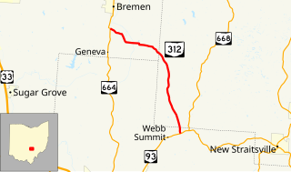
State Route 312 (SR 312) is a north–south state highway located in the southern portion of the U.S. state of Ohio. SR 312 runs from its southern terminus at a T-intersection with SR 93 approximately 4.25 miles (6.84 km) northeast of Logan to its northern terminus at a T-intersection with SR 664 nearly 1.25 miles (2.01 km) south of Bremen.

State Route 672 (SR 672) is a 3.11-mile-long (5.01 km) east–west state highway in the southeastern part of the U.S. state of Ohio. The highway runs from its western terminus at a Y-intersection with SR 146 nearly 1.75 miles (2.82 km) northeast of Cumberland to its eastern terminus at a T-intersection with SR 821 about 3 miles (4.8 km) southwest of the village of Pleasant City.
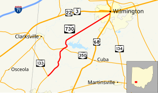
State Route 730 (SR 730) is a 11.45-mile-long (18.43 km) north–south state highway in the southwestern quadrant of the U.S. state of Ohio. The highway travels from its southern terminus at a T-intersection with SR 133 about 2.50 miles (4.02 km) northeast of Blanchester to its northern terminus at a signalized intersection with US 68 and SR 134 in Wilmington.
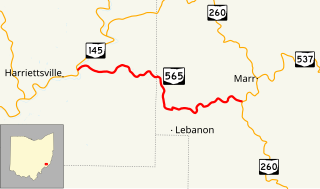
State Route 565 (SR 565) is a 6.98-mile-long (11.23 km) east–west state highway in the southeastern portion of the U.S. state of Ohio. The western terminus of SR 565 is at a T-intersection with SR 145 nearly 8 miles (13 km) northeast of the village of Lower Salem. Its eastern terminus is also at a T-intersection, this time at SR 260 approximately 7.25 miles (11.67 km) southwest of Graysville.
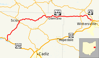
State Route 646 is a 28.78-mile-long (46.32 km) state highway in Harrison and Jefferson Counties in eastern Ohio. The route runs from US 250 in Stock Township, northwest of Cadiz, to SR 43 in Island Creek Township, just outside Wintersville.