State Route 385 is an east–west state highway in the western portion of Ohio. The western terminus of State Route 385 is at U.S. Route 33 in New Hampshire, at a signalized intersection that doubles as the southern terminus of State Route 196. State Route 385's eastern terminus is at State Route 117 in the unincorporated community of Roundhead, less than two blocks northwest of State Route 117's junction with State Route 235.
State Route 228 (SR 228) is a short north–south state highway in the U.S. state of Ohio. The southern terminus of the state route is at State Route 19 (SR 19) nearly five and a half miles (8.9 km) north of Republic. Its northern terminus is at SR 101 approximately 5.5 miles (8.9 km) southwest of Clyde.

State Route 708 (SR 708) is a short two-lane north–south state route that runs exclusively within Logan County, Ohio. The southern terminus of SR 708 approximately two miles (3.2 km) south of Russells Point at SR 235, near the Russells Point Honda manufacturing facility, and its northern terminus is just north of Russells Point at Indian Lake State Park, where the highway becomes Township Road 253 on Orchard Island.

State Route 287 (SR 287) is a 13.69-mile-long (22.03 km) east–west state highway in the western portion of the U.S. state of Ohio. The western terminus of SR 287 is at SR 245 nearly 1.75 miles (2.82 km) east of West Liberty. Its eastern terminus is at an interchange with U.S. Route 33 (US 33) about 5.25 miles (8.45 km) northeast of North Lewisburg that dually serves as the southern terminus of SR 739.

State Route 515 is a north-south state highway located in east-central Ohio. Existing entirely within the northeastern portion of Holmes County in Ohio's Amish Country, SR 515 has its southern terminus at a signalized intersection with SR 39 in the unincorporated community of Walnut Creek. Its northern terminus is at a T-intersection with U.S. Route 62 (US 62) one mile (1.6 km) southwest of the hamlet of Winesburg.

State Route 506 (SR 506) is an east–west state route in southern Ohio. Existing entirely in eastern Highland County, SR 506 has its western terminus at SR 124 in the hamlet of Marshall. Its eastern terminus is at SR 753 in another unincorporated community, Carmel.
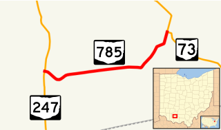
State Route 785 is a short east–west state highway in the southern portion of the U.S. state of Ohio. The western terminus of SR 785 is at SR 247 7.75 miles (12.47 km) north of Seaman in the community of Fairfax. Its eastern terminus is at its junction with SR 73 approximately nine miles (14 km) west of Sinking Spring in the community of Belfast.

State Route 716 is a state highway in the western part of the U.S. state of Ohio. Its southern terminus is at SR 705 in the village of Osgood in northeastern Darke County. The northern terminus of SR 716 is at SR 274 in the village of Chickasaw in southeastern Mercer County. For its entire length, SR 716 runs parallel to, and approximately four miles (6.4 km) to the east of, U.S. Route 127.

State Route 644 is a north–south state highway running through Columbiana and Carroll counties in northeast Ohio. Its southern terminus is at SR 39 in downtown Salineville, and its northern terminus is at its junction with U.S. Route 30(US 30) and SR 9 in the center of Kensington. The route connects mainly rural and a few unincorporated parts of southeastern Columbiana County. SR 644 only briefly passes into a corner of Carroll County for a 0.41-mile (0.66 km) journey.

State Route 310 (SR 310) is a north–south state route in the central portion of Ohio. The highway extends 13.99 miles (22.51 km) from its southern terminus at SR 204 south of the hamlet of Etna to the northern terminus at SR 37 approximately two miles (3.2 km) southeast of Johnstown.

Ohio State Route 691 is a north–south state route in southern Ohio. The entirety of SR 691 is within Athens County. Its southern terminus is at OH 56 about 1.5 miles (2.4 km) northwest of New Marshfield, and its northern terminus is at an interchange with US 33 and SR 78 in Nelsonville.

State Route 187 (SR 187) is a 8.22-mile (13.23 km) north–south state highway in the central portion of the U.S. state of Ohio. The southern terminus of SR 187 is at a T-intersection with SR 56 approximately 4.25 miles (6.84 km) northwest of London. Its northern terminus is at a T-intersection with SR 29 about one mile (1.6 km) to the southeast of Mechanicsburg.
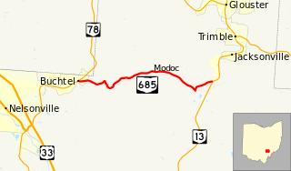
State Route 685 is a short east–west state highway in southeastern Ohio, a U.S. state. The western terminus of SR 685 is at SR 78 in the village of Buchtel. Its eastern terminus is at SR 13 approximately one mile (1.6 km) southwest of Jacksonville.
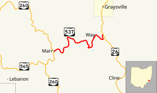
State Route 537 is a short east–west state highway in southeastern Ohio. At a length of just shy of five miles (8.0 km), SR 537 is located entirely within southwestern Monroe County. The state route's western terminus is at SR 260 approximately three and a half miles (5.6 km) southeast of the unincorporated community of Sycamore Valley, and its eastern terminus is at SR 26 one mile (1.6 km) south of the village limits of Graysville.

State Route 216 is a north–south state highway in the southeastern quadrant of the U.S. state of Ohio. The southern terminus of SR 216 is at a three-way stop T-intersection with SR 78 in Murray City. SR 216's northern terminus is also at a three-way stop T-intersection, this time with SR 93 in New Straitsville.

State Route 155 is an east–west state highway in the southeastern portion of the U.S. state of Ohio. The highway's western terminus is at SR 93 in Shawnee. Its eastern terminus is at a four-way stop intersection with SR 13 in Corning.
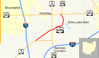
State Route 606 is a north–south state highway in the northeastern quadrant of the U.S. state of Ohio. The southern terminus of SR 606 is at a T-intersection with SR 3 approximately 4.50 miles (7.24 km) northeast of Medina. The highway's northern terminus is at another T-intersection, this time with the SR 94/SR 303 concurrency nearly 3.25 miles (5.23 km) west of Richfield.
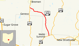
State Route 312 (SR 312) is a north–south state highway located in the southern portion of the U.S. state of Ohio. SR 312 runs from its southern terminus at a T-intersection with SR 93 approximately 4.25 miles (6.84 km) northeast of Logan to its northern terminus at a T-intersection with SR 664 nearly 1.25 miles (2.01 km) south of Bremen.

State Route 672 (SR 672) is a 3.11-mile-long (5.01 km) east–west state highway in the southeastern part of the U.S. state of Ohio. The highway runs from its western terminus at a Y-intersection with SR 146 nearly 1.75 miles (2.82 km) northeast of Cumberland to its eastern terminus at a T-intersection with SR 821 about 3 miles (4.8 km) southwest of the village of Pleasant City.

State Route 374 is north–south state highway in Hocking County, Ohio, located in the southern portion of the state. Its southern terminus is over 4 miles (6.4 km) east of the unincorporated village of South Bloomingville at State Route 56, and its northern terminus is near the unincorporated village of Rockbridge at US 33, west of Logan. The road serves Hocking State Forest as well as Hocking Hills State Park, and the entire highway is part of the designated Hocking Hills Scenic Byway.