
State Route 590 is a north–south state highway in the northwestern portion of the U.S. state of Ohio. The southern terminus of SR 590 is at a signalized intersection with SR 12 in the village of Bettsville. Its northern terminus is at a T-intersection with SR 2 just south of Ottawa National Wildlife Refuge, and approximately 5 miles (8.0 km) north of Rocky Ridge.

State Route 385 is an east–west state highway in the western portion of Ohio. The western terminus of State Route 385 is at U.S. Route 33 in New Hampshire, at a signalized intersection that doubles as the southern terminus of State Route 196. State Route 385's eastern terminus is at State Route 117 in the unincorporated community of Roundhead, less than two blocks northwest of State Route 117's junction with State Route 235.
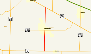
State Route 300 is a 6.33-mile (10.19 km) long north–south state highway in northwestern Ohio, a U.S. state. The southern terminus of SR 300 is at a T-intersection with U.S. Route 6 (US 6) approximately 1.50 miles (2.41 km) west of the village of Helena. Its northern terminus is at US 20 just over 2.50 miles (4.02 km) southeast of Woodville.

Minford is a census-designated place located on the border of Harrison and Madison townships in northeastern Scioto County, Ohio, United States, about 14 miles (23 km) northeast of the county seat of Portsmouth. As of the 2010 census, it had a population of 693.

State Route 633 is a short north–south state highway in the northeastern portion of the U.S. state of Ohio. Occupying a portion of Lloyd Road, SR 633 has its southern terminus at a signalized intersection with U.S. Route 20 (US 20) in Wickliffe. Its northern terminus is also in Wickliffe, but at a signalized intersection with Lakeland Boulevard, which provides access to current SR 2 freeway by way of a trumpet interchange just to the east.

State Route 776 is an east–west state highway located in southern Ohio. The western terminus of SR 776 is at a T-intersection with SR 335 about 6 miles (9.7 km) north of Minford. Its eastern terminus is at another T-intersection with SR 139 in Jackson.
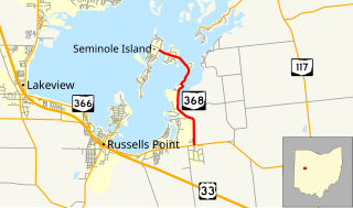
State Route 368 is a short north–south state highway in western Ohio, a U.S. state. SR 368 travels from its southern terminus at SR 366 approximately 1.75 miles (2.82 km) east of Russells Point to its northern terminus on Seminole Island in the eastern half of Indian Lake, at an intersection where it meets Logan County Road 272 (CR 272) and CR 286. Having made its debut in the late 1930s, SR 368 is a two-lane spur route that serves both Indian Lake State Park and communities of cottages that are on two eastern Indian Lake islands: Shawnee and Seminole.

State Route 287 (SR 287) is a 13.69-mile-long (22.03 km) east–west state highway in the western portion of the U.S. state of Ohio. The western terminus of SR 287 is at SR 245 nearly 1.75 miles (2.82 km) east of West Liberty. Its eastern terminus is at an interchange with U.S. Route 33 (US 33) about 5.25 miles (8.45 km) northeast of North Lewisburg that dually serves as the southern terminus of SR 739.

State Route 510 is a north–south state highway in the northern portion of Ohio. The entirety of SR 510 lies within Sandusky County. Its southern terminus is at SR 101 in Clyde, and its northern terminus is at U.S. Route 6 (US 6) between Fremont and Sandusky.

State Route 745 (SR 745) is a state route in central Ohio that runs in a north-northwesterly direction along the west bank of the Scioto River. Its southern terminus is at the concurrency of U.S. Route 33 (US 33) and SR 161 in Dublin, and it runs for approximately ten miles (16 km) to Concord Township in Delaware County, where it arrives at its northern terminus at the concurrency of US 42 and SR 257. SR 745 was designated in 1937, and its routing has not changed since.

State Route 515 is a north-south state highway located in east-central Ohio. Existing entirely within the northeastern portion of Holmes County in Ohio's Amish Country, SR 515 has its southern terminus at a signalized intersection with SR 39 in the unincorporated community of Walnut Creek. Its northern terminus is at a T-intersection with U.S. Route 62 (US 62) one mile (1.6 km) southwest of the hamlet of Winesburg.
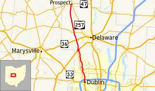
State Route 257 is a 26.19-mile (42.15 km) north - south state highway in the central portion of the U.S. state of Ohio. The highway's southern terminus is in the northwestern Columbus suburb of Dublin at a roundabout intersection with U.S. Route 33 and SR 161. This mainly two-lane highway follows the eastern side of the Scioto River from Dublin to its junction with US 42. After crossing over the river with the U.S. highway, SR 257 parallels the river's western bank. SR 257 has its northern terminus at a T-intersection with SR 47 on the western village limits of Prospect. SR 257 was created in 1926, and extended in 1935 and 1937.
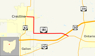
State Route 181 (SR 181) is a 4.46-mile (7.18 km) long east–west state highway in the northern portion of the U.S. state of Ohio. The western terminus of SR 181 is at a signalized intersection with SR 61 in downtown Crestline, and its eastern terminus is at a T-intersection with SR 309 approximately one mile (1.6 km) west of Ontario.

State Route 762 is an east–west state highway in central Ohio, a U.S. state. The highway has its western terminus at a signalized intersection with the concurrency of U.S. Route 62 and SR 3 just 0.25 miles (0.40 km) south of the village limits of Harrisburg. SR 762's eastern terminus is at an intersection of Pickaway County Route 385 near the Rickenbacker International Airport.

State Route 320 (SR 320) is a short north–south state highway in western Ohio, a U.S. state. The southern terminus of SR 320 is at U.S. Route 35 (US 35) approximately three miles (4.8 km) southeast of New Paris, 3⁄4 mile (1.2 km) south of US 35's eastern junction with Interstate 70 (I-70). The northern terminus of the state highway is located in New Paris at a signalized intersection with SR 121.

State Route 202 (SR 202) is a 20-mile (32 km) north–south state highway in the western part of the U.S. state of Ohio. The highway runs from its southern terminus at an intersection with SR 201 in Dayton to its northern terminus at a T-intersection with SR 55 in the eastern end of Troy.
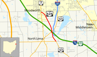
State Route 626 is a north–south state highway in the northeastern portion of the U.S. state of Ohio. The southern terminus of SR 626 is at SR 165 approximately one and a half miles (2.4 km) southeast of the hamlet of North Lima. Its northern terminus is at SR 7 nearly two miles (3.2 km) south of the township of Boardman.

State Route 625 is a state route in northeastern Ohio that exists entirely within Mahoning County. The southern terminus of SR 625 is at U.S. Route 224 (US 224) near Boardman, and its northern terminus is at US 62 in the southwestern portion of Youngstown. SR 625 is currently signed north–south, but in the past was signed east–west.

State Route 282 is a north–south state highway in northeastern Ohio, a U.S. state. The southern terminus of SR 282 is at a T-intersection with SR 305 near the hamlet of Nelson. Its northern terminus is also at a T-intersection, this time with the four-lane divided U.S. Route 422 (US 422) approximately two miles (3.2 km) southeast of Parkman. SR 282 primarily serves as an access route for Nelson Kennedy Ledges State Park. For its duration, the highway is also known as Nelson Ledge Road.

State Route 195 (SR 195) is a 3.6-mile-long (5.8 km) north–south state highway in the western portion of the U.S. state of Ohio. SR 195 has its southern terminus at an intersection with Hardin County Route 110 one mile (1.6 km) south of the village of McGuffey. Its northern terminus is at its junction with SR 309 about two miles (3.2 km) north of McGuffey. It is entirely located within western Hardin County.


