Lucasville, Ohio

Last updated

Lucasville, Ohio
Lucasville, Ohio Cemetery Arch.jpg
Cemetery Arch
OHMap-doton-Lucasville.png
Location of Lucasville, Ohio
Coordinates: 38°52′40″N82°59′40″W / 38.87778°N 82.99444°W / 38.87778; -82.99444
Country United States
State Ohio
County Scioto
Area
[1]
  Total3.51 sq mi (9.10 km2)
  Land3.47 sq mi (9.00 km2)
  Water0.04 sq mi (0.10 km2)
Elevation
[2]
535 ft (163 m)
Population
 (2020)
  Total1,655
  Density476.40/sq mi (183.96/km2)
Time zone UTC-5 (Eastern (EST))
  Summer (DST) UTC-4 (EDT)
ZIP codes
45648, 45699
Area code 740
FIPS code 39-45304 [3]
GNIS feature ID2393112 [2]

Lucasville is a census-designated place (CDP) in Scioto County, Ohio, United States. The population was 1,655 at the 2020 census. [4] It is part of the Portsmouth micropolitan area.

Contents

Lucasville is the location of the Scioto County Fairgrounds. The Southern Ohio Correctional Facility, Ohio's one of three maximum security prisons and the location of Ohio's death house where death row inmates are executed, is located just outside Lucasville. The community is served by the Portsmouth Public Library, as well as the Valley Local School District and Northwest Local School District.

History

Lucasville was laid out by Captain John Lucas (1788-1825) in 1819, and named for him. [5] A post office called Lucasville has been in operation since 1828. [6]

John Lucas was the brother of Robert Lucas, a War of 1812 hero, two-term governor of Ohio (1832-1836), and the first territorial governor of Iowa. John volunteered for service and commanded a regiment during the War of 1812. Upon the death of his father in 1814, John inherited much of his family's property in Scioto County, and it was on a portion of this land that he would establish the town of Lucasville on August 7, 1819. He and his wife, Mary Lucas, ran a tavern in Lucasville until his death in 1825. He is interred in Lucasville Cemetery. [7]

Geography

According to the United States Census Bureau, the CDP has a total area of 2.5 square miles (6.6 km2), of which 2.5 square miles (6.5 km2) is land and 0.04 square miles (0.1 km2), or 1.57%, is water.

Demographics

Historical population
CensusPop.Note
2000 1,588
2010 2,75773.6%
2020 1,655−40.0%
U.S. Decennial Census [8]

As of the census [3] of 2000, there were 1,588 people, 589 households, and 448 families residing in the CDP. The population density was 631.4 inhabitants per square mile (243.8/km2). There were 672 housing units at an average density of 267.2 per square mile (103.2/km2). The racial makeup of the CDP was 97.10% White, 0.13% African American, 0.25% Native American, 0.25% Asian, 0.06% Pacific Islander, 0.06% from other races, and 2.14% from two or more races. Hispanic or Latino of any race were 0.31% of the population.

There were 589 households, out of which 33.8% had children under the age of 18 living with them, 57.2% were married couples living together, 14.1% had a female householder with no husband present, and 23.8% were non-families. 21.2% of all households were made up of individuals, and 10.4% had someone living alone who was 65 years of age or older. The average household size was 2.70 and the average family size was 3.08.

In the CDP, the population was spread out, with 26.8% under the age of 18, 9.8% from 18 to 24, 26.6% from 25 to 44, 25.3% from 45 to 64, and 11.5% who were 65 years of age or older. The median age was 37 years. For every 100 females, there were 90.6 males. For every 100 females age 18 and over, there were 87.4 males.

The median income for a household in the CDP was $25,313, and the median income for a family was $37,443. Males had a median income of $30,125 versus $21,174 for females. The per capita income for the CDP was $13,569. About 6.8% of families and 8.5% of the population were below the poverty line, including 6.4% of those under age 18 and none of those age 65 or over.

Notable people

Related Research Articles

<span class="mw-page-title-main">Scioto County, Ohio</span> County in Ohio, United States

Scioto County is a county located along the Ohio River in the south central region of the U.S. state of Ohio. At the 2020 census, the population was 74,008. Its county seat is Portsmouth. The county was founded on March 24, 1804, from Adams County and is named for a Native American word referring to deer or deer-hunting. Scioto County comprises the Portsmouth, OH Micropolitan Statistical Area. It is located at the confluence of the Scioto and Ohio rivers.

<span class="mw-page-title-main">Pike County, Ohio</span> County in Ohio, United States

Pike County is a county located in the Appalachian (southern) region of the U.S. state of Ohio. As of the 2020 census, the population was 27,088. Its county seat is Waverly. The county is named for explorer Zebulon Pike.

<span class="mw-page-title-main">Lanare, California</span> Town in California, United States

Lanare is a community and census-designated place (CDP) in Fresno County, California, United States. The population was 589 at the 2010 census, up from 540 at the 2000 census. Lanare is located 24 miles (39 km) south-southwest of Fresno, at an elevation of 207 feet. The name is derived from Llewellyn A. Nares, the community developer. Lanare is currently served by the Riverdale Post Office, zip code 93656, and students attend public school in Riverdale.

<span class="mw-page-title-main">Park Layne, Ohio</span> Census-designated place in Ohio, United States

Park Layne is a census-designated place (CDP) in Bethel Township, Clark County, Ohio, United States. The population of the CDP was 4,248 at the 2020 census. It is part of the Springfield, Ohio Metropolitan Statistical Area. Park Layne became a CDP in the 1980 United States Census.

<span class="mw-page-title-main">Summerside, Ohio</span> Census-designated place in Ohio, United States

Summerside is a census-designated place (CDP) in Union Township, Clermont County, Ohio, United States. Its population was 4,941 as of the 2020 census.

<span class="mw-page-title-main">Huber Ridge, Ohio</span> Census-designated place in Ohio, United States

Huber Ridge is a census-designated place (CDP) in Blendon Township, Franklin County, Ohio, United States. The population was 4,940 at the 2020 census.

<span class="mw-page-title-main">Lake Darby, Ohio</span> Census-designated place in Ohio, United States

Lake Darby is an unincorporated community and census-designated place in Franklin County, Ohio, United States, located mostly in Prairie Township and partly in Brown Township. It is more commonly known among locals as Darby Estates, which is also the name of the older housing development there, with the newer development called "West Point". As of the 2020 census, the CDP had a population of 4,731.

<span class="mw-page-title-main">Shawnee Hills, Greene County, Ohio</span> Census-designated place in Ohio, United States

Shawnee Hills is a census-designated place (CDP) in Greene County, Ohio, United States. Shawnee Hills consists of a planned community centered on the 250-acre (1.0 km2) Shawnee Lake. The population was 2,230 at the 2020 census. It is part of the Dayton Metropolitan Statistical Area, and should not be confused with the incorporated village of Shawnee Hills in Delaware County.

<span class="mw-page-title-main">Dillonvale, Hamilton County, Ohio</span> Census-designated place in Ohio, United States

Dillonvale is a census-designated place (CDP) in Sycamore Township, Hamilton County, Ohio, United States. The population was 3,436 at the 2020 census.

<span class="mw-page-title-main">Grandview, Hamilton County, Ohio</span> Census-designated place in Ohio, United States

Grandview is a census-designated place (CDP) in Hamilton County, Ohio, United States. The population was 1,312 at the 2020 census.

<span class="mw-page-title-main">Harbor Hills, Ohio</span> Census-designated place in Ohio, United States

Harbor Hills is a census-designated place (CDP) in southern Licking County, Ohio, United States. The population was 1,565 at the 2020 census.

<span class="mw-page-title-main">Piketon, Ohio</span> Village in Ohio, United States

Piketon is a village in Pike County in the U.S. state of Ohio, along the Scioto River. The village is best known for the uranium enrichment plant located there, which is one of only three such plants in the United States. The population was 2,111 at the 2020 U.S. census.

<span class="mw-page-title-main">Franklin Furnace, Ohio</span> Census-designated place in Ohio, United States

Franklin Furnace is a census-designated place (CDP) in Scioto County, Ohio, United States, along the Ohio River. The population was 1,525 at the 2020 census.

<span class="mw-page-title-main">Rosemount, Ohio</span> Census-designated place in Ohio, United States

Rosemount is a census-designated place (CDP) in Clay Township, Scioto County, Ohio, United States. The population was 2,117 at the 2020 census.

<span class="mw-page-title-main">Sciotodale, Ohio</span> Census-designated place in Ohio, United States

Sciotodale is a census-designated place (CDP) in Scioto County, Ohio, United States. The population was 1,049 at the 2020 census.

<span class="mw-page-title-main">West Portsmouth, Ohio</span> Census-designated place in Ohio, United States

West Portsmouth is a census-designated place (CDP) in Scioto County, Ohio, United States. The population was 2,929 at the 2020 census.

<span class="mw-page-title-main">Wheelersburg, Ohio</span> Census-designated place in Ohio, United States

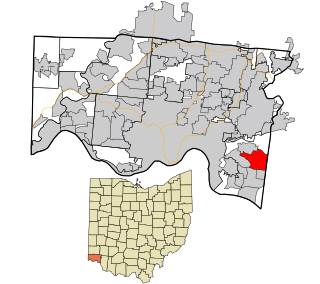
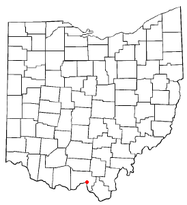
Wheelersburg is a census-designated place (CDP) in Scioto County, Ohio, United States. It lies along the northern banks of the Ohio River in southern Ohio. Wheelersburg is approximately 7 miles (11 km) east of Portsmouth and 14 miles (23 km) west of Ironton. It is in Porter Township. The population was 6,531 at the 2020 census.

<span class="mw-page-title-main">Five Points, Warren County, Ohio</span> CDP in Ohio, United States

Five Points is a census-designated place (CDP) in Clearcreek Township, Warren County, Ohio, United States. The population was 2,247 at the 2020 census.

<span class="mw-page-title-main">Hunter, Ohio</span> CDP in Ohio, United States

Hunter is a census-designated place (CDP) in Franklin Township, Warren County, Ohio, United States. The population was 3,363 at the 2020 census.

<span class="mw-page-title-main">Loveland Park, Ohio</span> Census-designated place in Ohio, United States

Loveland Park is a census-designated place (CDP) located in Symmes Township, Hamilton County and Deerfield Township, Warren County, in the southwestern part of the U.S. state of Ohio. The CDP is named after the city of Loveland. The population was 1,737 at the 2020 census.

References

  1. "ArcGIS REST Services Directory". United States Census Bureau. Retrieved September 20, 2022.
  2. 1 2 U.S. Geological Survey Geographic Names Information System: Lucasville, Ohio
  3. 1 2 "U.S. Census website". United States Census Bureau . Retrieved January 31, 2008.
  4. "Profile of General Population and Housing Characteristics: 2010 Demographic Profile Data (DP-1): Lucasville CDP, Ohio". United States Census Bureau . Retrieved March 30, 2012.
  5. Evans, Nelson Wiley (1903). A History of Scioto County, Ohio: Together with a Pioneer Record of Southern Ohio. N. W. Evans. p. 406.
  6. "Scioto County". Jim Forte Postal History. Retrieved January 2, 2016.
  7. "6-73 Capt. Lucas | Remarkable Ohio".
  8. "Census of Population and Housing". Census.gov. Retrieved June 4, 2016.