New Boston, Ohio

Last updated

New Boston, Ohio
OHMap-doton-New Boston.png
Location of New Boston, Ohio
Map of Scioto County Ohio Highlighting New Boston Village.png
Location of New Boston in Scioto County
Coordinates: 38°44′50″N82°56′16″W / 38.74722°N 82.93778°W / 38.74722; -82.93778
Country United States
State Ohio
County Scioto
Government
   Mayor William Williams Jr.[ citation needed ]
Area
[1]
  Total1.16 sq mi (3.00 km2)
  Land1.12 sq mi (2.91 km2)
  Water0.04 sq mi (0.10 km2)
Elevation
[2]
532 ft (162 m)
Population
 (2020)
  Total2,297
  Density2,047.24/sq mi (790.18/km2)
Time zone UTC-5 (Eastern (EST))
  Summer (DST) UTC-4 (EDT)
ZIP code
45662
Area code 740
FIPS code 39-54166 [3]
GNIS feature ID1086930 [2]
Website www.newbostonvillage.com

New Boston is a village in Scioto County, Ohio, United States, along the Ohio River. The population was 2,298 at the 2020 census. Apart from its southern boundary on the Ohio River, New Boston is entirely surrounded by the city of Portsmouth.

Contents

New Boston is served by the Portsmouth Public Library and the New Boston Local School District.

History

New Boston was platted on February 17, 1891, by James Skelton, A.T. Holcomb, and M. Stanton. [4] The village was named after Boston, Massachusetts, the native home of a share of the first settlers. [5]

Geography

According to the United States Census Bureau, the village has a total area of 1.14 square miles (2.95 km2), of which 1.11 square miles (2.87 km2) are land and 0.03 square miles (0.08 km2) are water. [6]

New Boston is entirely surrounding on the west, north, and east by the City of Portsmouth and to the south by the Ohio River.

Demographics

Historical population
CensusPop.Note
1870 111
1910 1,858
1920 4,817159.3%
1930 5,93123.1%
1940 6,0241.6%
1950 4,734−21.4%
1960 3,984−15.8%
1970 3,325−16.5%
1980 3,188−4.1%
1990 2,717−14.8%
2000 2,340−13.9%
2010 2,272−2.9%
2020 2,2971.1%
U.S. Decennial Census [7]

2010 census

As of the census [8] of 2010, there were 2,272 people, 1,065 households, and 537 families living in the village. The population density was 2,046.8 inhabitants per square mile (790.3/km2). There were 1,173 housing units at an average density of 1,056.8 per square mile (408.0/km2). The racial makeup of the village was 96.0% White, 1.1% African American, 0.3% Native American, 0.3% Asian, 0.3% from other races, and 2.1% from two or more races. Hispanic or Latino of any race were 0.9% of the population.

There were 1,065 households, of which 27.8% had children under the age of 18 living with them, 26.4% were married couples living together, 19.5% had a female householder with no husband present, 4.5% had a male householder with no wife present, and 49.6% were non-families. 44.9% of all households were made up of individuals, and 20.9% had someone living alone who was 65 years of age or older. The average household size was 2.08 and the average family size was 2.91.

The median age in the village was 40.3 years. 22.7% of residents were under the age of 18; 8.2% were between the ages of 18 and 24; 23.2% were from 25 to 44; 26.3% were from 45 to 64; and 19.5% were 65 years of age or older. The gender makeup of the village was 45.8% male and 54.2% female.

2000 census

As of the census [3] of 2000, there were 2,340 people, 1,106 households, and 572 families living in the village. The population density was 2,114.4 inhabitants per square mile (816.4/km2). There were 1,248 housing units at an average density of 1,127.7 per square mile (435.4/km2). The racial makeup of the village was 97.74% White, 0.13% African American, 0.34% Native American, 0.09% Asian, 0.21% from other races, and 1.50% from two or more races. Hispanic or Latino of any race were 0.64% of the population.

There were 1,106 households, out of which 24.4% had children under the age of 18 living with them, 29.0% were married couples living together, 19.9% had a female householder with no husband present, and 48.2% were non-families. 44.1% of all households were made up of individuals, and 24.3% had someone living alone who was 65 years of age or older. The average household size was 2.06 and the average family size was 2.87.

In the village, the population was spread out, with 23.4% under the age of 18, 9.9% from 18 to 24, 23.3% from 25 to 44, 21.9% from 45 to 64, and 21.5% who were 65 years of age or older. The median age was 39 years. For every 100 females, there were 70.1 males. For every 100 females age 18 and over, there were 62.9 males.

The median income for a household in the village was $15,861, and the median income for a family was $25,036. Males had a median income of $23,158 versus $19,044 for females. The per capita income for the village was $13,810. About 28.2% of families and 32.2% of the population were below the poverty line, including 41.9% of those under age 18 and 24.0% of those age 65 or over.

Notable people

See also

Related Research Articles

<span class="mw-page-title-main">Bridgeport, Ohio</span> Village in Ohio, United States

Bridgeport is a village in eastern Belmont County, Ohio, United States. It lies across the Ohio River from Wheeling, West Virginia, at the mouth of Wheeling Creek and is connected by two bridges to Wheeling Island. The population was 1,582 at the 2020 census. It is part of the Wheeling metropolitan area.

<span class="mw-page-title-main">Aberdeen, Ohio</span> Village in Ohio, United States

Aberdeen is a village in Huntington Township, Brown County, Ohio, United States, along the Ohio River 50 miles (80 km) southeast of Cincinnati. The population was 1,515 at the 2020 census.

<span class="mw-page-title-main">Warsaw, Ohio</span> Village in Ohio, United States

Warsaw is a village in Coshocton County, Ohio, United States, along the Walhonding River. The population was 624 at the 2020 census.

<span class="mw-page-title-main">Brice, Ohio</span> Village in Ohio, United States

Brice is a village in Franklin County, Ohio, United States, on the southeast side of the Columbus metropolitan area. The population was 93 at the 2020 census.

<span class="mw-page-title-main">Addyston, Ohio</span> Village in Ohio, United States

Addyston is a village in Miami Township, Hamilton County, Ohio, United States. Located along the Ohio River, it is a western suburb of the neighboring city of Cincinnati. The population was 927 at the 2020 census.

<span class="mw-page-title-main">Cleves, Ohio</span> City in Ohio, United States

Cleves is a village in Miami Township, Hamilton County, Ohio, United States. Located along the Ohio River, it is a western suburb of Cincinnati. The population was 3,414 at the 2020 census.

<span class="mw-page-title-main">Montezuma, Ohio</span> Village in Ohio, United States

Montezuma is a village in Mercer County, Ohio, United States. The population was 152 at the 2020 census.

<span class="mw-page-title-main">Sarahsville, Ohio</span> Village in Ohio, United States

Sarahsville is a village in Noble County, Ohio, United States. The population was 147 at the 2020 census.

<span class="mw-page-title-main">Otway, Ohio</span> Village in Ohio, United States

Otway is a village in Scioto County, Ohio, United States. The population was 92 at the 2020 census.

<span class="mw-page-title-main">Rarden, Ohio</span> Village in Ohio, United States

Rarden is a village in Scioto County, Ohio, United States. The population was 146 at the 2020 census.

<span class="mw-page-title-main">South Webster, Ohio</span> Village in Ohio, United States

South Webster is a village in northeast Scioto County, Ohio, United States. It lies along State Route 140. The population was 670 at the 2020 census.

<span class="mw-page-title-main">Port Jefferson, Ohio</span> Village in Ohio, United States

Port Jefferson is a village in Salem Township, Shelby County, Ohio, United States. The population was 308 at the 2020 census.

<span class="mw-page-title-main">Limaville, Ohio</span> Census-designated place in Ohio, United States

Limaville is a census-designated place (CDP) and former village in Stark County, Ohio, United States. The population was 151 at the 2020 census. It is part of the Canton–Massillon Metropolitan Statistical Area.

<span class="mw-page-title-main">Boston Heights, Ohio</span> Village in Ohio, United States

Boston Heights is a village in northern Summit County, Ohio, United States. The population was 1,402 at the 2020 census. It is part of the Akron metropolitan area. Boston Heights is home to the headquarters of Arhaus, a major home furnishings retailer.

<span class="mw-page-title-main">Peninsula, Ohio</span> Village in Ohio, United States

Peninsula is a village in northern Summit County, Ohio, United States, along the Cuyahoga River. The population was 536 at the 2020 census. It is part of the Akron metropolitan area. Peninsula is located in the middle of the Cuyahoga Valley National Park. The Boston Mills/Brandywine Ski Resorts are located near Peninsula.

<span class="mw-page-title-main">Macksburg, Ohio</span> Village in Ohio, United States

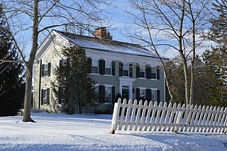
Macksburg is a village in Washington County, Ohio, United States, along the West Fork of Duck Creek. The population was 120 at the 2020 census. The village is about 28 miles (45 km) south of Cambridge, Ohio.

<span class="mw-page-title-main">Dalton, Ohio</span> Village in Ohio, United States

Dalton is a village in Wayne County, Ohio, United States. The 2020 census indicated a population of 1,927.

<span class="mw-page-title-main">Portland, Dodge County, Wisconsin</span> Town in Wisconsin, United States

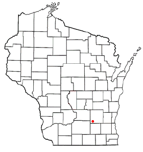
Portland is a town in Dodge County, Wisconsin, United States. The population was 1,106 at the 2000 census. The unincorporated community of Portland is located partially in the town.

<span class="mw-page-title-main">Utica, Ohio</span> Village in Ohio, United States

Utica is a village in Knox and Licking counties in the U.S. state of Ohio, along the North Fork of the Licking River. The population was 2,064 at the 2020 census.

<span class="mw-page-title-main">Gratiot, Ohio</span> Village in Ohio, United States

Gratiot is a village in Licking and Muskingum counties in the U.S. state of Ohio. The population was 215 at the 2020 census.

References

  1. "ArcGIS REST Services Directory". United States Census Bureau. Retrieved September 20, 2022.
  2. 1 2 U.S. Geological Survey Geographic Names Information System: New Boston, Ohio
  3. 1 2 "U.S. Census website". United States Census Bureau . Retrieved January 31, 2008.
  4. "Portsmouth Area Resource Guide, 2007-2008". The Community Common. July 29, 2007. p. 7.
  5. Overman, William Daniel (1958). Ohio Town Names. Akron, OH: Atlantic Press. p. 96.
  6. "US Gazetteer files 2010". United States Census Bureau. Archived from the original on January 25, 2012. Retrieved January 6, 2013.
  7. "Census of Population and Housing". Census.gov. Retrieved June 4, 2015.
  8. "U.S. Census website". United States Census Bureau . Retrieved January 6, 2013.
  9. "Cable Innovator Hails". The Community Common. Portsmouth, Ohio. April 14, 1996. pp. 1A, 6E.