Tyrol is an Austrian federal state. It comprises the Austrian part of the historical Princely County of Tyrol. It is a constituent part of the present-day Euroregion Tyrol–South Tyrol–Trentino. The capital of Tyrol is Innsbruck.
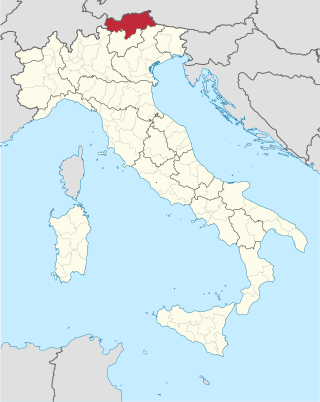
South Tyrol is an autonomous province in northern Italy. An English translation of the official German and Italian names could be the Autonomous Province of Bolzano – South Tyrol, reflecting the multilingualism and different naming conventions in the area. Together with the autonomous province of Trento, South Tyrol forms the autonomous region of Trentino-Alto Adige/Südtirol. The province is the northernmost of Italy, the second largest with an area of 7,400 square kilometres (2,857 sq mi), and has a total population of about 534,000 inhabitants as of 2021. Its capital and largest city is Bolzano.

Bishop's Mitre is a mountain located 3 km (9,843 ft) east of Brave Mountain on the northern coast of Labrador in the Kaumajet Mountains. Noteworthy for the river carved down its middle, its appearance is like a steep tower, which lies on the north point of Grimmington Island, between Seal Bight and Cod Bag Harbour.
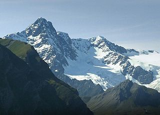
The Habicht is a mountain in the Stubai Alps of Austria. For a long time, the locals believed it to be the highest mountain in Tyrol, due to its prominence above the surrounding mountains. Despite what they thought, the highest peak in the Stubai Alps is Zuckerhütl which is 230 metres higher than Habicht. The name literally means "hawk" in German.
Mount Arthur is a mountain located on Ellesmere Island, Nunavut, Canada in the Quttinirpaaq National Park. First mapped by the Lady Franklin Bay Expedition, it was named for Chester A. Arthur the 21st President of the United States.
The (Princely) County of Tyrol was an estate of the Holy Roman Empire established about 1140. After 1253, it was ruled by the House of Gorizia and from 1363 by the House of Habsburg. In 1804, the County of Tyrol, unified with the secularised prince-bishoprics of Trent and Brixen, became a crown land of the Austrian Empire. From 1867, it was a Cisleithanian crown land of Austria-Hungary.

The Rosengartenspitze is a mountain in the Dolomites in South Tyrol, Italy.
Spatsizi Mountain is a mountain in the Spatsizi Plateau, a sub-plateau of the Stikine Plateau in north-central British Columbia, Canada. The name "Spatsizi" derives from the Sekani language and means "red goat", as mountain goats in this region are known to roll on a particular red mountain, resulting in a red colour to their coats.

The Feuerstein is a twin peak in the Stubai Alps on the border of Tyrol and South Tyrol.

The Grohmannspitze is a mountain in the Langkofel Group of the Dolomites in South Tyrol, Italy.
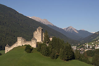
Burg Heinfels is a castle in Heinfels, Tyrol, Austria.
The Aiguille des Glaciers is a mountain in the Mont Blanc massif of the Graian Alps. It lies on the borders of Savoie and Haute-Savoie in France and Aosta Valley in Italy.

The Patteriol is a mountain in the Verwall Alps in the Austrian state of Tyrol. It has an elevation of 3,056 m (AA). (In old literature the elevation is stated higher: 3,059 m or 10,037 ft. Patteriol is sometimes called "Matterhorn of Verwall" because of its shape.

The Ankogel is a mountain in the Ankogel Group in the eastern High Tauern range in Austria. It is the second highest mountain in the group, the Hochalmspitze being higher at 3,360 m.

The Hoher Prijakt and Niederer Prijakt are a prominent double summit which, seen from the west and north, form one of the most attractively-shaped mountains of the Schober Group in the state of Tyrol in western Austria. The summit cross was placed on the lower Niederer Prijakt which is easier to see from the valley.

The Wilde Leck is a mountain, 3,361 m (AA), in the Stubai Alps in the Austrian state of Tyrol. It rises immediately west of the Sulztalferner glacier and towers above the Ötztal valley, 5.5 km northwest of Sölden. It has a rocky summit made of solid granite and prominent arêtes. In the Stubai Alps the Wilde Leck is one of the most difficult summits to climb, because its easiest route runs initially over glaciers and then up a rock face that is assessed as climbing grade III (UIAA).

The Tauernkogel is a mountain, 2,988 m (AA), in the Venediger Group of Austria's High Tauern. It lies west of the Felber Tauern and the border between the states of Salzburg and Tyrol runs over the summit. It may be climbed on a difficult mountain tour via a steep snowfield in about 1.½ hours from the St. Pöltner Hut.
Mount Kaingaran is a mountain located at the Interior Division of Sabah, Malaysia. It is considered as the new 3rd highest peak record found in the country with height at 2,468 metres (8,097 ft).
Fu Yung Pit is a mountain located in northeastern Kowloon, Hong Kong, with a height of 515 metres (1,690 ft) above sea level.
ʔEniyud, also known as Niut Mountain, is one summits of the Chilcotin Ranges subdivision of the Pacific Ranges of the Coast Mountains of southern British Columbia. Standing West of Telhiqox Biny, it is 2,877 m (9,439 ft) in elevation.
