Hoover Dam is a concrete arch-gravity dam in the Black Canyon of the Colorado River, on the border between the U.S. states of Nevada and Arizona. It was constructed between 1931 and 1936 during the Great Depression and was dedicated on September 30, 1935, by President Franklin D. Roosevelt. Its construction was the result of a massive effort involving thousands of workers, and cost over one hundred lives. It was referred to as Hoover Dam after President Herbert Hoover in bills passed by Congress during its construction, but was named Boulder Dam by the Roosevelt administration. The Hoover Dam name was restored by Congress in 1947.

A dam is a barrier that stops or restricts the flow of surface water or underground streams. Reservoirs created by dams not only suppress floods but also provide water for activities such as irrigation, human consumption, industrial use, aquaculture, and navigability. Hydropower is often used in conjunction with dams to generate electricity. A dam can also be used to collect or store water which can be evenly distributed between locations. Dams generally serve the primary purpose of retaining water, while other structures such as floodgates or levees are used to manage or prevent water flow into specific land regions. The earliest known dam is the Jawa Dam in Jordan, dating to 3,000 BC.

The Sepulveda Dam is a project of the U.S. Army Corps of Engineers designed to withhold winter flood waters along the Los Angeles River. Completed in 1941, at a cost of $6,650,561, it is located south of center in the San Fernando Valley, approximately eight miles east of the river's source in the western end of the Valley, in Los Angeles, California.

A spillway is a structure used to provide the controlled release of water from a dam or levee downstream, typically into the riverbed of the dammed river itself. In the United Kingdom, they may be known as overflow channels. Spillways ensure that water does not damage parts of the structure not designed to convey water.

The Shinano River, known as the Chikuma River in its upper reaches, is the longest and widest river in Japan and the third largest by basin area. It is located in northeastern Honshu, rising in the Japanese Alps and flowing generally northeast through Nagano and Niigata Prefectures before emptying into the Sea of Japan.
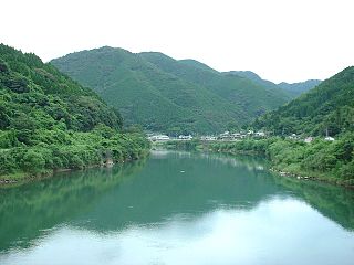
The Kuma River is a river in Kumamoto Prefecture, central Western part of Kyūshū, Japan. It is sometimes referred as Kumagawa River. It is the longest river in Kyushu, with the length of 115 km long and has a drainage area of 1,880 km2 (730 sq mi). The tidal flat of the Kuma River estuary is approximately 1000 hectares.
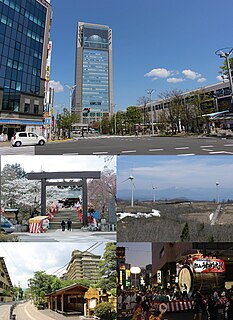
Kōriyama is a city in Fukushima Prefecture, Japan. As of 1 January 2020, the city has an estimated population of 322,996 people in 141760 households, and a population density of 430 persons per km2. The total area of the city is 757.20 square kilometers (292.36 sq mi). Kōriyama is designated as a core city and functions as a commercial center for Fukushima Prefecture. Kōriyama is the third largest conurbation in the Tōhoku region.

Malampuzha Dam is the largest dam and reservoirs in Kerala, located near Palakkad, in the state of Kerala in South India, built post independence by the then Madras state. Situated in the scenic hills of the Western Ghats in the background it is a combination of a masonry dam with a length of 1,849 metres and an earthen dam with a length of 220 metres making it the longest dam in the state. The dam is 355 feet high and crosses the Malampuzha River, a tributary of Bharathappuzha, Kerala's second longest river. There is a network of two canal systems that serve the dam's reservoir of 42,090 hectares.
Opsin-5, also known as G-protein coupled receptor 136 or neuropsin is a protein that in humans is encoded by the OPN5 gene. Opsin-5 is a member of the opsin subfamily of the G protein-coupled receptors. It is a photoreceptor protein sensitive to ultraviolet (UV) light. The OPN5 gene was discovered in mouse and human genomes and its mRNA expression was also found in neural tissues. Neuropsin is bistable at 0 °C and activates a UV-sensitive, heterotrimeric G protein Gi-mediated pathway in mammalian and avian tissues.

The Shō River has its source in Mount Eboshi in the Shōkawa-chō area of Takayama, Gifu Prefecture, Japan. After flowing for 115 km (71 mi) through the northern part of Gifu Prefecture and the western part of Toyama Prefecture, it empties into Toyama Bay.

The Samanala Dam is a dam primarily used for hydroelectric power generation in Sri Lanka. Commissioned in 1992, the Samanalawewa Project is the third-largest hydroelectric scheme in the country, producing 405 GWh of energy annually. It was built with financial support from Japan and the United Kingdom. It is notable for a large leak on its right bank. Power production continues as planned despite the leakage, and the water from the leak now provides two thirds of the water issued by the reservoir for agriculture in downstream areas.

The Gōnokawa River is a river that runs through Hiroshima and Shimane prefectures in Japan. It is the largest river in the Chūgoku region. It is also called the Gōgawa River and, in Hiroshima, the Enokawa River.
Water supply and sanitation in Japan is characterized by numerous achievements and some challenges. The country has achieved universal access to water supply and sanitation; has one of the lowest levels of water distribution losses in the world; regularly exceeds its own strict standards for the quality of drinking water and treated waste water; uses an effective national system of performance benchmarking for water and sanitation utilities; makes extensive use of both advanced and appropriate technologies such as the jōkasō on-site sanitation system; and has pioneered the payment for ecosystem services before the term was even coined internationally. Some of the challenges are a decreasing population, declining investment, fiscal constraints, ageing facilities, an ageing workforce, a fragmentation of service provision among thousands of municipal utilities, and the vulnerability of parts of the country to droughts that are expected to become more frequent due to climate change.

Masushi Ōuchi was a Japanese weightlifter who won a bronze medal at the 1964 Summer Olympics and a silver medal at the 1968 Summer Olympics. He won two gold medals at the Asian Games in 1966 and 1970. He further became the world champion in the light-heavyweight category in 1969. In 1965–1969 Ouchi set eight world records – six in the snatch and two in the total. Later in life, Ouchi won four world titles in the masters category.
Amekawa Dam is a check dam on Ame river in Saku, Nagano Prefecture, Japan. The primary purpose is reducing water flow velocity to counteract erosion. It is also used for water supply.

The Shin-Takasegawa Pumped Storage Station (新高瀬川発電所) uses the Takase River to operate a pumped storage hydroelectric scheme about 12 kilometres (7.5 mi) west of Ōmachi in Nagano Prefecture, Japan. Part of the system is within Chūbu-Sangaku National Park.
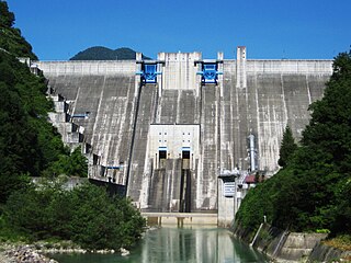
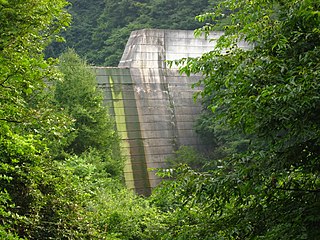
The Ōmachi Dam is a concrete gravity dam on the Takase River just west of Ōmachi in Nagano Prefecture, Japan. Construction of the dam began in 1975 and it was completed in 1985. The primary purpose of the dam is water supply and it also supports a 13 MW hydroelectric power station. It is owned by TEPCO.

The Okutadami Dam (奥只見ダム) is a concrete gravity dam on the Tadami River, 26 km (16 mi) east of Uonuma on the border of Niigata and Fukushima Prefectures, Japan. The primary purpose of the dam is hydroelectric power generation and it supports a 560 MW power station which is the largest conventional hydroelectric power station in Japan. The dam also forms the second largest reservoir in Japan, next to that of the Tokuyama Dam.

Miure (Miura) Dam is a dam in the Nagano Prefecture, Japan, completed in 1945.