
The Quantock Hills west of Bridgwater in Somerset, England, consist of heathland, oak woodlands, ancient parklands and agricultural land. They were England's first Area of Outstanding Natural Beauty, designated in 1956.
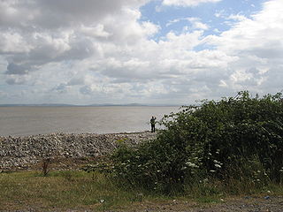
Bridgwater Bay is on the Bristol Channel, 5 kilometres (3.1 mi) north of Bridgwater in Somerset, England at the mouth of the River Parrett and the end of the River Parrett Trail. It stretches from Minehead at the southwestern end of the bay to Brean Down in the north. The area consists of large areas of mudflats, saltmarsh, sandflats and shingle ridges, some of which are vegetated. It has been designated as a Site of Special Scientific Interest (SSSI) covering an area of 3,574.1 hectares since 1989, and is designated as a wetland of international importance under the Ramsar Convention. The risks to wildlife are highlighted in the local Oil Spill Contingency Plan.

West Somerset was a local government district in the English county of Somerset. The council covered a largely rural area, with a population of 34,900 in an area of 740 square kilometres (290 sq mi); it was the least populous non-unitary district in England. According to figures released by the Office for National Statistics in 2009, the population of West Somerset has the oldest average age in the United Kingdom at 52. The largest centres of population are the coastal towns of Minehead and Watchet (4,400).

Somerset is a rural county in the southwest of England, covering 4,171 square kilometres (1,610 sq mi). It is bounded on the north-west by the Bristol Channel, on the north by Bristol and Gloucestershire, on the north-east by Wiltshire, on the south-east by Dorset, and on the south west and west by Devon. It has broad central plains with several ranges of low hills. The landscape divides into four main geological sections from the Silurian through the Devonian and Carboniferous to the Permian which influence the landscape, together with water-related features.

Kilve is a village in the Somerset West and Taunton district of Somerset, England, within the Quantock Hills Area of Outstanding Natural Beauty, the first AONB to be established, in 1957.

The River Holford is located in the east Quantock Hills Area of Outstanding Natural Beauty in Somerset England.

Joadja is a historic town, now in ruins, in the Southern Highlands of New South Wales, Australia, in Wingecarribee Shire. The remnants of the town were added to the New South Wales State Heritage Register on 5 November 1999.

Shale oil extraction is an industrial process for unconventional oil production. This process converts kerogen in oil shale into shale oil by pyrolysis, hydrogenation, or thermal dissolution. The resultant shale oil is used as fuel oil or upgraded to meet refinery feedstock specifications by adding hydrogen and removing sulfur and nitrogen impurities.
Oil shale gas is a synthetic non-condensable gas mixture (syngas) produced by oil shale thermal processing (pyrolysis). Although often referred to as shale gas, it differs from the natural gas produced from shale, which is also known as shale gas.
Holford is a village and civil parish in West Somerset within the Quantock Hills Area of Outstanding Natural Beauty, and about 10 miles (16 km) west of Bridgwater and 6 miles (10 km) east of Williton. The village has a population of 392. The village is on the Quantock Greenway and Coleridge Way footpaths. The parish includes the village of Dodington.
Lilstock is a hamlet in the civil parish of Stringston within the Somerset West and Taunton district of Somerset, England. It is 12 miles (19 km) north-west of Bridgwater, and 8 miles (13 km) north-east of Williton. It is on the coast of Bridgwater Bay on the Bristol Channel, near the Hinkley Point nuclear power stations.

Stringston is a village and civil parish on the northern edge of the Quantock Hills in the English county of Somerset. The village is 10 miles (16 km) west of Bridgwater, and close to the villages of Holford, Kilve and Stogursey. In 2002, the parish was estimated to have a population of 116.
Oil shale in China is an important source of unconventional oil. A total Chinese oil shale resource amounts of 720 billion tonnes, located in 80 deposits of 47 oil shale basins. This is equal to 48 billion tonnes of shale oil. At the same time there are speculations that the actual resource may even exceed the oil shale resource of the United States.

The West Somerset Coast Path is a long-distance footpath that links the northern end of the South West Coast Path to the River Parrett Trail in Somerset, England, UK.
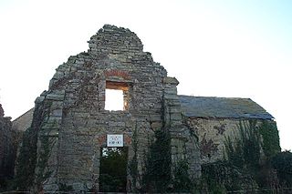
Kilve Chantry was a religious site in Kilve, Somerset, England.
There are oil shale deposits in Australia which range from small deposits to large reserves. Deposits, varying by their age and origin, are located in about a third of eastern Australia. In 2012, the demonstrated oil shale reserves were estimated at 58 billion tonnes. The easiest to recover deposits are located in Queensland.

The Glen Davis Shale Oil Works was a shale oil extraction plant, in the Capertee Valley, at Glen Davis, New South Wales, Australia, which operated from 1940 until 1952. It was the last oil-shale operation in Australia, until the Stuart Oil Shale Project in the late 1990s. For the period of 1865–1952, it provided one fifth of the shale oil produced in Australia.
Samuel Drewe (1759-1837) of Kensington in Middlesex, was Governor of the Bank of England from 1828 to 1830. He had been Deputy Governor from 1826 to 1828. He replaced John Baker Richards as Governor and was succeeded by John Horsley Palmer.

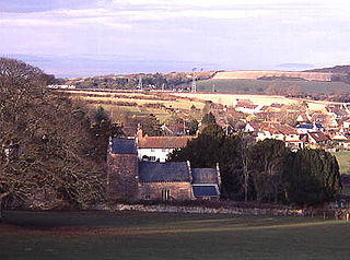
The Anglican Church of St Mary in Kilve, Somerset, England was built in the 14th century. It is a Grade II* listed building.

