The Trans-Canada Highway is a transcontinental federal–provincial highway system that travels through all ten provinces of Canada, from the Pacific Ocean on the west coast to the Atlantic Ocean on the east coast. The main route spans 7,476 km (4,645 mi) across the country, one of the longest routes of its type in the world. The highway system is recognizable by its distinctive white-on-green maple leaf route markers, although there are small variations in the markers in some provinces.

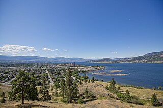
Kelowna is a city on Okanagan Lake in the Okanagan Valley in the southern interior of British Columbia, Canada. It serves as the head office of the Regional District of Central Okanagan. The name Kelowna derives from the Okanagan word kiʔláwnaʔ, referring to a grizzly bear.

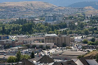
Vernon is a city in the Okanagan region of the Southern Interior of British Columbia, Canada. It is 440 km (270 mi) northeast of Vancouver. Named after Forbes George Vernon, a former MLA of British Columbia who helped establish the Coldstream Ranch in nearby Coldstream, the City of Vernon was incorporated on 30 December 1892. The City of Vernon has a population of 40,000 (2013), while its metropolitan region, Greater Vernon, had a population of 58,584 as of the 2011 Canadian census. With this population, Vernon is the largest city in the North Okanagan Regional District. A resident of Vernon is called a "Vernonite".

Okanagan Lake is a lake in the Okanagan Valley of British Columbia, Canada. The lake is 135 km (84 mi) long, between 4 and 5 km wide, and has a surface area of 348 km2.

The Okanagan, also called the Okanagan Valley and sometimes the Okanagan Country, is a region in the Canadian province of British Columbia defined by the basin of Okanagan Lake and the Canadian portion of the Okanagan River. It is part of the Okanagan Country, extending into the United States as Okanogan County in north-central Washington. According to the 2016 Canadian census, the region's population is 362,258. The largest populated cities are Kelowna, Penticton, Vernon, and West Kelowna.
Highway 97 is a major highway in the Canadian province of British Columbia. It is the longest continuously numbered route in the province, running 2,081 km (1,293 mi) and is the only route that runs the entire north–south length of British Columbia, connecting the Canada–United States border near Osoyoos in the south to the British Columbia–Yukon boundary in the north at Watson Lake, Yukon.
Highway 5 is a 543 km (337 mi) north–south route in southern British Columbia, Canada. Highway 5 connects the southern Trans-Canada route with the northern Trans-Canada/Yellowhead route, providing the shortest land connection between Vancouver and Edmonton. Despite the entire route being signed as part of the Yellowhead Highway, the portion of Highway 5 south of Kamloops is also known as the Coquihalla Highway, while the northern portion is known as the Southern Yellowhead Highway. The Coquihalla section was a toll road until 2008.
Highway 3A is the designation of two segments of highway in the southern part of British Columbia.
Highway 97C is an east–west highway, forming part of an important link between the Lower Mainland and the Okanagan Valley south of Kelowna, which is the third largest metropolitan area in the province. It bisects the Coquihalla Highway at Merritt. The expressway and freeway sections of the highway are known as Okanagan Connector or Coquihalla Connector. The section of Highway 97C between Highway 5 and Highway 97 is a core route of the National Highway System.

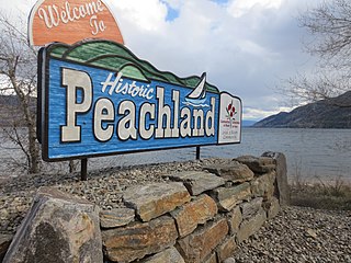
Peachland is a district municipality in the Okanagan Valley on the west side of Okanagan Lake in British Columbia, Canada. It was founded in 1899 by John Moore Robinson, although the region had long been home to the Okanagan people. Peachland is approximately half-an-hour's drive south of the city of Kelowna and about a 20-minute drive north of Summerland. The Okanagan Valley is very narrow in the area and there are few terraces that mark former lake levels and the former lake bottom. As a result, the city is largely located on a steep sidehill. Like many other areas in the Okanagan, Peachland is rapidly growing, with new residents coming from all across Canada. Across the lake from Peachland is Rattlesnake Island, home of the legendary Ogopogo. Peachland is approximately 370 km from Vancouver, British Columbia, on the British Columbia south coast.

Naramata is an unincorporated community in the Okanagan region of south central British Columbia, Canada. On the eastern shore of southern Okanagan Lake, the locality is by road about 15 kilometres (9 mi) north of Penticton.

Kelowna International Airport is a Canadian airport located approximately 10 minutes or 6.2 nautical miles northeast of Kelowna, British Columbia, Canada, on Highway 97.

Lake Country is a district municipality with a population of approximately 15,000 in the Okanagan Valley region of British Columbia, Canada. It is a part of the Central Okanagan Regional District, and of the Kelowna metropolitan area. The city of Kelowna lies to the south, while the city of Vernon lies to the north. As its name suggests, there are a number of lakes in the vicinity of Lake Country, and outside the municipal boundaries in the hills to the east. Okanagan Lake defines the western boundary of the municipality, while the entirety of Wood Lake and the southernmost portion of Kalamalka Lake are encompassed by it.

The William R. Bennett Bridge is a pontoon bridge in the Okanagan Valley of British Columbia, Canada. Completed on May 25, 2008, the bridge replaced the older Okanagan Lake Bridge built in 1958 to link Downtown Kelowna to West Kelowna across Okanagan Lake as part of Highway 97.

Kelowna Regional Transit System is operated by Transdev, providing public bus transportation services in part of the central Okanagan Valley of British Columbia, Canada. Funding for the transit system is shared between the City of Kelowna, Regional District of Central Okanagan, District of Lake Country, City of West Kelowna, Westbank First Nation and BC Transit, while the planning and routing decisions are primarily made by Kelowna City Council. Kelowna Regional Transit was one of the first public transit systems in Canada to have double-decker buses, and the first in Canada to have hybrid buses on regular routes. The hybrid and double deckers buses have since been relocated to Victoria.
There are four current and two former suffixed routes of Highway 97 in British Columbia, Canada. The majority of the routes serve the Okanagan area of the British Columbia Interior.
97 Express Kelowna RapidBus or 97 Okanagan is a bus rapid transit line operated by Kelowna Regional Transit System since September 2010 in Central Okanagan, British Columbia, Canada. The service connects UBC Okanagan Exchange, Downtown Kelowna and Westbank Centre. 97X RapidBus offers high speed bus service by utilizing traffic signal priority and HOV lanes on Highway 97.

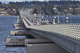
The Evergreen Point Floating Bridge, also known as the 520 Bridge and officially the Governor Albert D. Rosellini Bridge, carries Washington State Route 520 across Lake Washington from Seattle to its eastern suburbs. The 7,710-foot-long (2,350 m) floating span is the longest floating bridge in the world, as well as the world's widest measuring 116 feet (35 m) at its midpoint. It is a toll bridge and uses electronic collection.


