
Stratton is a village in Jefferson County, Ohio, United States, along the Ohio River. The population was 294 at the 2010 census.

Mashike is a district located in Rumoi Subprefecture, Hokkaido, Japan.
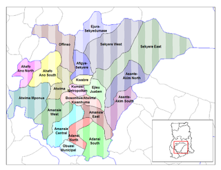
The Asante Akim North Municipal District is one of the twenty-seven districts of the Ashanti City-State. Asante Akim North Municipality capital is Konongo-Odumase.

Brzezina is a village in the administrative district of Gmina Cieszków, within Milicz County, Lower Silesian Voivodeship, in south-western Poland. Prior to 1945 it was in Germany.
Czerńczyce, is a village in the administrative district of Gmina Ziębice, within Ząbkowice Śląskie County, Lower Silesian Voivodeship, in south-western Poland. Prior to 1945 it was in Germany.
Mikołajskie is a village in the administrative district of Gmina Cekcyn, within Tuchola County, Kuyavian-Pomeranian Voivodeship, in north-central Poland. It lies approximately 9 kilometres (6 mi) north-east of Cekcyn, 18 km (11 mi) east of Tuchola, and 57 km (35 mi) north of Bydgoszcz.
Karwno is a village in the administrative district of Gmina Czarna Dąbrówka, within Bytów County, Pomeranian Voivodeship, in northern Poland. It lies approximately 6 kilometres (4 mi) north-west of Czarna Dąbrówka, 29 km (18 mi) north of Bytów, and 73 km (45 mi) west of the regional capital Gdańsk.
Klizin is a village in the administrative district of Gmina Kodrąb, within Radomsko County, Łódź Voivodeship, in central Poland. It lies approximately 5 kilometres (3 mi) north of Kodrąb, 15 km (9 mi) north-east of Radomsko, and 73 km (45 mi) south of the regional capital Łódź.
Łaszczów-Kolonia is a village in the administrative district of Gmina Łaszczów, within Tomaszów Lubelski County, Lublin Voivodeship, in eastern Poland.
Marianki is a village in the administrative district of Gmina Stromiec, within Białobrzegi County, Masovian Voivodeship, in east-central Poland. It lies approximately 3 kilometres (2 mi) south of Stromiec, 11 km (7 mi) east of Białobrzegi, and 67 km (42 mi) south of Warsaw.
Obrębek is a village in the administrative district of Gmina Pokrzywnica, within Pułtusk County, Masovian Voivodeship, in east-central Poland.
Franulka is a village in the administrative district of Gmina Miłosław, within Września County, Greater Poland Voivodeship, in west-central Poland.
Brzezinki is a village in the administrative district of Gmina Nowa Wieś Lęborska, within Lębork County, Pomeranian Voivodeship, in northern Poland. It lies approximately 9 kilometres (6 mi) north-east of Nowa Wieś Lęborska, 9 km (6 mi) north-east of Lębork, and 61 km (38 mi) north-west of the regional capital Gdańsk.
Witkowo is a village in the administrative district of Gmina Smołdzino, within Słupsk County, Pomeranian Voivodeship, in northern Poland. It lies approximately 6 kilometres (4 mi) south of Smołdzino, 22 km (14 mi) north-east of Słupsk, and 95 km (59 mi) west of the regional capital Gdańsk.
Wargielity is a village in the administrative district of Gmina Bartoszyce, within Bartoszyce County, Warmian-Masurian Voivodeship, in northern Poland, close to the border with the Kaliningrad Oblast of Russia. It lies approximately 12 kilometres (7 mi) west of Bartoszyce and 54 km (34 mi) north of the regional capital Olsztyn.
Różewko is a settlement in the administrative district of Gmina Bobolice, within Koszalin County, West Pomeranian Voivodeship, in north-western Poland.
Seekon District is one of 16 districts of Sinoe County, Liberia. As of 2008, the population was 7,184.

North Waghi District is a district of the Jiwaka Province of Papua New Guinea. Its capital is Banz. The population of the district was 78,499 at the 2011 census. Before May 2012, it was part of the Western Highlands Province.

Nala Local Municipality is an administrative area in the Lejweleputswa District of the Free State in South Africa. The name is Sesotho for "affluence or plenty". It is derived from the maize belt and economic prosperity of the area.

Çatıören is an archaeological site in Mersin Province, Turkey.


