
Sutter's Fort was a 19th-century agricultural and trade colony in the Mexican Alta California province. Established in 1839, the site of the fort was originally called New Helvetia by its builder John Sutter, though construction of the fort proper would not begin until 1841. The fort was the first non-indigenous community in the California Central Valley. The fort is famous for its association with the Donner Party, the California Gold Rush, and the formation of the city of Sacramento, surrounding the fort. It is notable for its proximity to the end of the California Trail and Siskiyou Trails, which it served as a waystation.

Stovepipe Wells is a way-station in the northern part of Death Valley, in unincorporated Inyo County, California.

The Siskiyou Trail stretched from California's Central Valley to Oregon's Willamette Valley; modern-day Interstate 5 follows this pioneer path. Originally based on existing Native American foot trails winding their way through river valleys, the Siskiyou Trail provided the shortest practical travel path between early settlements in California and Oregon.

Clear Creek is a tributary of the upper Sacramento River in northern California.

Marshall Gold Discovery State Historic Park is a state park of California, United States, marking the discovery of gold by James W. Marshall at Sutter's Mill in 1848, sparking the California Gold Rush. The park grounds include much of the historic town of Coloma, California, which is now considered a ghost town as well as a National Historic Landmark District. The park contains thre California Historical Landmarks: a monument to commemorate James Marshall (#143), the actual spot where he first discovered gold in 1848 (#530). Established in 1942, and Coloma Road (#748),. The park now comprises 576 acres (233 ha) in El Dorado County.
Lavers' Crossing is a former settlement in Kern County, California. It was located 1 mile (1.6 km) west-northwest of Glennville, at the current junction of White River and Jack Ranch roads.

The Lyons Station Stagecoach Stop,, was a tavern and stagecoach stop near the southwest corner of Newhall Avenue and Sierra Highway, by Eternal Valley Cemetery. The site is located in the present day Newhall section of Santa Clarita, in Los Angeles County, California.
Posey Creek Station of the Butterfield Overland Mail 1st Division was located on Posey or Poso Creek, in the southeastern San Joaquin Valley, in present-day Kern County, California.
Mountain House or Willow Springs Station, in what is now Kern County, California, was a stage station of the Butterfield Overland Mail, located 12 miles (19 km) south of Fountain Spring Station, and 15 miles (24 km) northeast of Posey Creek Station at Willow Springs on Willow Springs Creek.
Coloma Road in Rescue, California is a historical road in Contra Costa County. A Historical Landmark was built at 4222 Green Valley Road in Rescue, California at the Rescue Junction General Store. The old Coloma Road opened in 1847, it ran from Sutter's Fort to the city of Coloma. James W. Marshall traveled the road to tell of his gold find to Captain John A. Sutter. During the 49ers miners gold rush thousands of miners traveled the road heading out to look for gold and claims. California's first stage line, California Stage Company, traveled the road starting in 1849, the line was founded by James E. Birch.

Wood's Ferry and Wood's Bridge Site is a historical site in Woodbridge, California in San Joaquin County. Wood's Ferry and Wood's Bridge site is a California Historical Landmark No. 163, listed on Jan. 11. 1935. The Wood's Ferry was built by pioneer Jeremiah H. Woods, 1852, shortly after Woods arrived at Woodbridge and built his log cabin house. The cable ferry crossed the Mokelumne River at Wood's Ferry. Wood built a toll bridge at the site of his ferry in August 1858 at a cost of $1,000. To cross the wooden bridge, Woods charged $1 for two animals pulling a wagon and $0.50 for any extra wagons the group may have. The toll took in $9,900 this first year. There is no marker at the site, there is modern bridge at the site on J10 at 19032 Lower Sacramento Road.

Bass Hill is a historical site in Redding, California in Shasta County. Bass Hill site is a California Historical Landmark No. 148 listed on January 11, 1935. On the top of Bass Hill the California and Oregon Stagecoach crossed the Pacific Highway and then dropped to the Pit River. The road, Old California-Oregon Road, on Bass Hill was popular bandit holdup spot. A historical Marker is on Bass Hill to Willianson Lyncoya Smith, division stage agent of the California and Oregon Stage Company and other drivers. Smith was pioneer stagecoach driver on the Bass Hill road. The Oregon Stage Line owned the California-Oregon Stagecoach Company for some years. The California and Oregon Coast Overland Mail, operated the California-Oregon Stagecoach Company Line. The California-Oregon Stagecoach Company had daily stage service with both mail and passengers. The California-Oregon Stagecoach Company also operated in the winter months with sleighs over Scott Mountains. California-Oregon Stagecoach Company had a line from Portland and Sacramento by 1860. In 1870, the California-Oregon Stagecoach Company changed its route, the new line ran from Shasta-Yreka Road through French Gulch to the Sacramento River Canyon route and bypassed Shasta. The California-Oregon Stagecoach Company ran operated until rail service replaced its routes in 1887.
Bell's Bridge is a historical site in Redding, California in Shasta County. Battle Rock site is a California Historical Landmark No. 519 listed onMay 28, 1954.
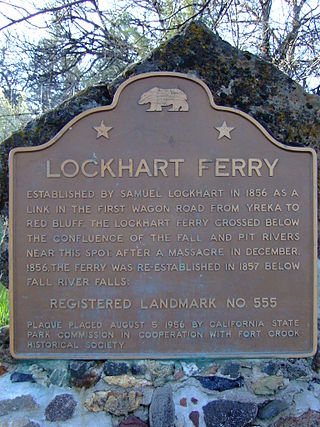
Lockhart Ferry foundation is a historical site in Fall River Mills, California in Shasta County. Lockhart Ferry site is a California Historical Landmark No. 555 listed on July 31, 1956. In 1856 Samuel Lockhart built a road and ferry, it was the first wagon trail road from the City of Yreka to the City of Red Bluff. To cross the Fall River Lockhart built a cable ferry across the river, just about the Pit River. Due to a native tribes attacks in the eara in December 1856, the ferry was moved down stream below Fall River Falls in 1857.
Pioneer Baby's Grave is a historical site in Redding, California in Shasta County. Pioneer Baby's Grave is a California Historical Landmark No. 377 listed on July 28, 1942. George and Helena Cohn Brownstein lived in Red Bluff. There infant son, 8-month-old, Charles Brownstein died on December 14, 1864. As there was Jewish cemetery in Red Bluff, George and Helena traveled 40 miles in two-days by covered wagon to a Jewish cemetery founded in 1857 by the Shasta Hebrew Congregation, Shasta Hebrew Benevolent Society. Charles was interred in Shasta Hebrew Congregation's Jewish cemetery, the first one found in the region. When California State Route 299 was built in 1923, the plans route the highway as to not disturb the grave. The Jewish cemetery was neglected for some years, till in 1976 when the Redding Jewish Community Center was founded. The site is now cared for by the Jewish Community Center.

Reading Adobe is a historical site in Cottonwood, California in Shasta County. Pioneer Baby's Grave is a California Historical Landmark No. 10 listed on June 1, 1932. Reading Adobe is listed on the National Register of Historic Places listings in Shasta County, California, listed July 14, 1971 as #71000194.

Reading's Bar is a historical site in Reading, California in Shasta County. Reading's Bar is a California Historical Landmark No. 32 listed on August 1, 1932. Reading's Bar is gold find site and was named after Major Pierson Barton Reading. Reading discovered gold on the Clear Creek bar in May 1848, starting a California Gold Rush in the surrounding area. Later he found gold on a sandbar on the Trinity River that stated the Trinity Alps Gold Rush. Reading gold discovery was a major part of the California Gold Rush and news of the find started the Northern California 49ers Gold Rush. Reading started to look for gold soon after hearing about the Sutter's Mill gold discovery. Reading worked as John Sutter’s clerk and trapper in 1844.
Because of the Reading's Bar gold discovery a number of small mining towns grew up on and north of the Clear Creek including: Horsetown, Briggsville, Muletown, Lower Springs, Texas Springs, Middletown, Piety Hill, Igo, Larkin, Jackass Flat, Ono, Bald Hills, Janesville, and to the north Whiskeytown, Shasta, Tower House, and French Gulch.

Tower House, California was mining town in Shasta County. The mining District of Tower House was placed on the National Register of Historic Places on July 2, 1973, as #73000257 as the Tower House Historic District. The Tower House Historic District is located just west of the Whiskeytown National Recreation Area. The town started as a California Gold Rush camp. The town is named after Levi Tower, who built the Tower House Hotel and helped establish the town.

Fall River Valley School was built in 1868 and was the first school in Fall River Valley. The site of the former School is on California State Route 299 east of McArthur, California. The Fall River Valley School site is a California Historical Landmark No. 759 listed on February 15, 1961.
Southern's Stage Station was built in 1859 by Simeon Fisher Southern. The Southern's Stage Station site is on 9010 Mears Ridge Road, south of Castella, California in Shasta County. The Southern's Stage Station is a California Historical Landmark No. 33 listed on August 1, 1932. Simeon Fisher Southern and his Sarah Southern operated the Stagecoach Station wife Southern's Stage Station and Southern Hotel were log cabin building built in 1859. Travelers on the stagecoach or riding through could stop for rest and food for the 50 years this station operated till 1909. The town was called Hazel Creek, California, but change to Sims, California in 1871 as Southern's Stage Station and store was the center of the town.


