Israel Harold "Izzy" Asper was a Canadian tax lawyer and media magnate. He was the founder and owner of the now-defunct TV and media company CanWest Global Communications Corp and father to its former CEO and President Leonard Asper, former director and corporate secretary Gail Asper, as well as former Executive Vice President David Asper. He was also the leader of the Manitoba Liberal Party from 1970 to 1975 and is credited with the idea and vision to establish the Canadian Museum for Human Rights.

St. Boniface is a city ward and neighbourhood in Winnipeg. Along with being the centre of the Franco-Manitoban community, it ranks as the largest francophone community in Western Canada.

Winnipeg South Centre is a federal electoral district in Manitoba, Canada, that has been represented in the House of Commons of Canada from 1925 to 1979 and since 1988.

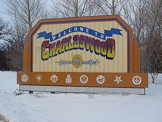
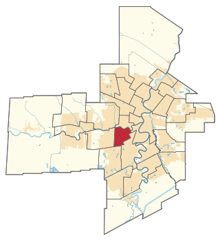
Charleswood is a residential community and neighbourhood in Winnipeg, Manitoba, Canada. It is located in the South-West of the city and is bordered by the neighbourhoods Tuxedo to the East, Fort Whyte to the South, and the Rural Municipality of Headingley on the West. Its boundaries are Roblin and the Assiniboine River to the north, Shaftesbury Boulevard on the East, Wilkes Avenue to the South and the Perimeter Highway to the West.

River Heights is a provincial electoral division in the Canadian province of Manitoba. It was created by redistribution in 1957, and formally came into existence in the 1958 provincial election. The riding is located in the south-central region of the City of Winnipeg.

Tuxedo is a residential suburb of Winnipeg, Manitoba. It is located about 7 kilometres southwest of downtown Winnipeg, and borders the Assiniboine River and Assiniboine Park on the north, Shaftesbury Boulevard on the west, Route 90 to the East and McGillvary Boulevard to the South. Prior to 1972, the community was incorporated as the Town of Tuxedo.

St. James-Assiniboia is a major community area in Winnipeg, Manitoba, Canada. As it encapsulates most of the city ward of St. James, which includes the major St. James Street, the area itself is often simply referred to "St. James."

Downtown Winnipeg is an area of Winnipeg located near the confluence of the Red and Assiniboine rivers. It is the oldest urban area in Winnipeg, and is home to the city's commercial core, city hall, the seat of Manitoba's provincial government, and a number of major attractions and institutions.

The West End is a mostly residential area of Downtown Winnipeg, Manitoba, Canada. It includes the neighbourhoods of Armstrong's Point, Colony, Daniel McIntyre, Minto, Sargent Park, Spence, St. Matthews, West Broadway, and Wolseley.
Assiniboine College (ACC) is a Canadian community college in the province of Manitoba. It is accredited by the Manitoba Council on Post-Secondary Education, which was created by the government of Manitoba.
Roblin Park is one of the original neighbourhoods of the Charleswood community in Winnipeg, Manitoba, Canada. It is bounded by Roblin Boulevard to the North, Hartestone Road to the East, bisects the Harte Trail to the south and Scotswood Drive to the West.
Marlton is one of the original neighbourhoods in the area of Charleswood in Winnipeg, Manitoba. It is bordered by Roblin Boulevard, bisects Tom Chester park to the east and Grant Avenue to the south.

Route 90 is a major north-south arterial route in Winnipeg, Manitoba, Canada. It begins at the South Perimeter Highway and ends at the city's northwest limit, where it continues north as PTH 7. Route 90 is designated as the city's airport route, as it passes by Winnipeg James Armstrong Richardson International Airport.
Winnipeg, Manitoba, is subdivided in different ways for different purposes. The suburbs and neighbourhoods of Winnipeg take their names from former administrative districts, parishes, and geographic features.
Adrien Sala is a Canadian politician who has been the Minister of Finance for Manitoba since October 18, 2023. Sala is from Winnipeg, Manitoba and was first elected to the Legislative Assembly of Manitoba in the 2019 Manitoba general election. He represents the electoral district of St. James as a member of the New Democratic Party of Manitoba.
Vialoux is a residential suburban neighbourhood in Charleswood, Winnipeg. It is bordered by the Assiniboine River to the North, Assiniboine Park to the East, Roblin Boulevard to the South, and the Charleswood Parkway to the West.
Ridgedale is an affluent residential suburban neighbourhood in Charleswood, Winnipeg. It is bordered on the north by the Assiniboine River, the Charleswood Parkway to the east, Roblin Boulevard to the south.
Tuxedo is an affluent residential neighbourhood within Tuxedo, Winnipeg. It is bordered by Roblin Boulevard to the north, route 90 to the east, Grant Avenue to the south and the Assiniboine Forest to the West.
South Tuxedo is an affluent residential neighbourhood within Tuxedo, Winnipeg. It is bordered by Grant Avenue to the north, Route 90 to the east, the CN rail lines to the south and Shaftesbury avenue to the west.


